

I got the idea to hike Vineyard Mountain from Mike_W on HikeArizona.com. Normally, I spend the winter months doing “locals’ hikes” in the Phoenix metro area, but I’d already postponed Vineyard Mountain too many times. Temps were supposed to be reasonable, despite Vineyard Mountain being squeezed between the Mazatzal Mountains and Supersition Mountains.
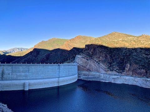
Vineyard Mountain is a 3,458 ft. peak, rising 1,500 ft. above the Salt River and Roosevelt Dam. As you stand at the dam overlook on AZ-88 Apache Trail, Vineyard Mountain is the fourth point, right-to-left. The first point is a no name knoll, the second is Inspiration Point, and the third is the site of the microwave relay (not visible from the overlook). Today, Vineyard Mountain was covered in green grass.
On the drive up from Phoenix, it was 33℉ in the little town of Tonto Basin at 7:45 a.m. Brrr! I would have hiked Vineyard Mountain anyway, but was not relishing the thought. Fifteen minutes later, at the still shady Hotel Point Trailhead, it was 43℉. Not a meteorologist, but thankful for whatever oddity caused that. Still, I waited an hour to head out, so I’d have half decent light for taking photos. 📸
Vineyard Trail #131 is co-located with Arizona Trail Passage 20, which traverses the Mazazatzal Mountains nineteen miles to Four Peaks. Vineyard Trail #131 is merely six miles to the Mills Ridge Trailhead at FR 429. A round trip to Mills Ridge Trailhead would be 2,700 ft. AEG (accumulated elevation gain). If you can do a Four Peaks round trip, God bless: I was sore enough as it was the next two days.
Vineyard Mountain is a tale of five short segments: In the first, you cross AZ-188 — traffic’s steady and there is a blind curve, so do it fast! — then follow Vineyard Trail #131 around the edge of the wash to the O’Rourke’s Camp history sign. The camp housed workers from 1905-1911, while Roosevelt Dam was built. The camp was later converted to the since-deceased hotel which gave Hotel Point it’s name.
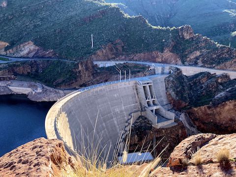
Vineyard Trail #131’s second segment climbs 500 switchbacked, often rocky, feet in a half mile. Halfway up that climb, at a right-hand switchback, there is a line of rocks to the left. If you go left, it is about 200 easy off trail yards to the best view of Roosevelt Dam. Pipes are embedded in the rocky promontory, and sections of cement wall are dotted about it.
Vineyard Mountain’s third segment gains a more moderate 100 ft. in the next third of a mile, around the east and north side of Inspiration Point. There’s even a welcome twenty foot dip. In shade at 10:00 a.m., that dip is where I found the first non-brittlebush flowers of my hike, tuber anemone (Anemone tuberosa) and desert paintbrush (Castilleja angustifolia). A helicopter made a run not far above. 🚁
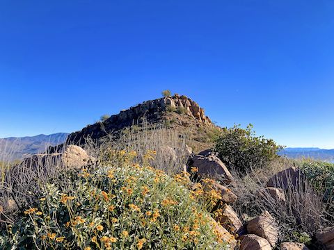
Vineyard Mountain Trail #131’s fourth segment climbs 500 more direct feet in the next half mile. 250 yds. after the dip, the trail crosses a saddle. From the saddle, it is only fifty feet up to the summit of Inspiration Point. I should have done it, but didn’t. The climb ends 100 yds. north of the microwave relay. At least that is what it looks like: Check out my hike video (below), to see if you can identify it.
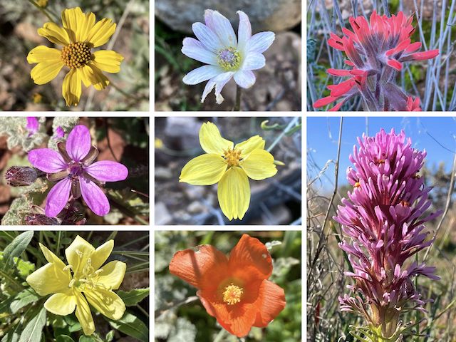
Top Row: brittlebush, tuber anemone, desert paintbrush.
Middle Row: redstem stork’s bill, whitestem paperflower, owl clover.
Bottom Row: desert evening primrose, desert globemallow.
Vineyard Mountain’s fifth & final segment is basically level the first 200 yds. Where Mike_W turned off to the summit, I built a cairn. It is only 150 grassy off trail feet up to the summit. Some of the grass was 12″ high. I didn’t think to look for the reference marks that are on Vineyard Mountain, but I had no problem finding the summit log. 📝
The first entry in Vineyard Mountain’s summit log was Bob Martin. Of course. Only surprise is it wasn’t the other Arizona peak bagging legend Bob Packard. Now I — a non-legend — am also in the summit log. Though calling Vineyard Mountain a “peak bag” is stretching it a wee bit: From Hotel Point, the hike is 1.8 miles, 1,260 ft. AEG, one way.
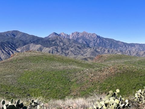
Vineyard Mountain’s summit had great 360° views of Roosevelt Lake (but not the dam or bridge), the Superstition Mountains, the Salt River downstream to Apache Lake, Buckhorn Ridge, Four Peaks, Three Bar State Wildlife Area, Dutchwoman Butte, and the Sierra Ancha. After thirty minutes taking photos, and perusing the summit log, I started back down.
Once back on Vineyard Trail #131, I made it back to Hotel Point in only forty minutes. (Not counting stops for the flowers that were beginning to appear in now 60℉ direct sunlight.) I was surprised to encounter two other hikers on what I thought was an obscure trail, and there were a half dozen vehicles at the Hotel Point Trailhead when I returned. No idea where they went. 🤷🏻♂️
Hotel Point Directions: From Phoenix, exit Loop 101 at Shea. Go east on Shea to the Beeline Highway (AZ-87). Go north on the Beeline Highway for 46 miles to AZ-188. Go east on AZ-188 for 31 miles. Just before the Roosevelt Lake Bridge, park in the pullout on the lakeside of the highway.
GPS File: Vineyard_Mountain_Trail_131
Distance: 4.61 mi.
AEG: 1,396 ft.
Time: 2h 28m
Rumble Video
Vimeo Video
Hiking Vineyard Mountain, Mazatzal Mountains from Preston McMurry on Vimeo.