
")
Any given Old West trail, rather than being a singular track — like, say, Interstate 40 — was a web of routes heading in the same general direction. The routes would diverge, wander, merge, and hopefully end up in the same place. (Unless you were the Donner Party, or Oatman Family.)
As a result, a given trail might be known by many names: San Antonio–San Diego Mail Line, Jackass Mail, Southern Emigrant Trail, Gila Trail, Kearny Trail, Mormon Battalion Trail, Southern Trail, and Butterfield Stage Trail all referred to the same general route. Overland Mail Company only operated from 1858-1861, but stages continued to follow the route until the railroad was completed in 1880. 🚂
Maricopa Wells, a famous stop on the Butterfield Stage Trail, now on the Gila River Indian Reservation, is about a day’s travel from Chistmas Camp, at North Tank, on West Prong Waterman Wash. So, I started today’s bike ride at the nearest possible point, Enid, ¼ mile from the Rez, nine miles west of Maricopa.
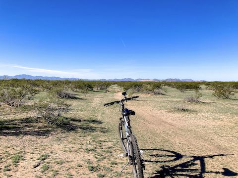
Most of the washes in the Sonoran Desert National Monument run south to north, from Mobile Valley, into Rainbow Valley, and eventually the Gila River at Buckeye, via Waterman Wash. If you see a wash going east-west for more than 100 yds., as Butterfield Stage Trail does, it is likely old trail bed.
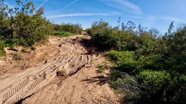
With the wear & tear of thousands of coaches, rain, and the passage of time, much of what was the Butterfield Stage Trail has turned into narrow, shallow, and densely-brushed washes. Where that was the case, I biked cross-country, closely paralleling the wash. In the attached GPS file, I’ve included the dashed topo map route (amended to satellite view ground wear patterns) and my actual biked route.
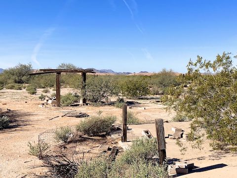
2.5 mi.: Riding cross-country on the south side of the “trail wash”, I found an old ranch / way station / corral / shooting range / garbage dump where Butterfield Stage Trail crosses “79th Ave.” (Serious! It’s dirt.) The area is a couple of acres. The dump’s big brother, Waste Management Company’s Butterfield Station Landfill, is the sandy-colored hill ahead. Riding cross-country, I aimed at the hill’s south tip.
3.5 mi.: Butterfield Stage Trail crosses Waterman Wash. Had to walk that one, but I rode others. My MTB is not a fat tire, so the key to avoid dabbing seems to be keeping the wheel straight. Other than washes, Rainbow Valley is hardpack desert. I could feel a little bit of sink — Maricopa County had record rain November — but the drag was minimal. Cross-country was easy, even for this fat man.
5.1 mi.: I arrived at the intersection of 91st Ave. and 99th Ave., at the base of the landfill. Steady truck traffic uses 91st Ave. for access. If you need, a car could pick you up here, or down 99th Ave. at Mobile School. Check out the ruins of the old brick building. (See video thumbnail, below.) The trail heads to the southwest corner but, again, it has decayed to wash. Make your way as best you can to Gas Pipeline Rd.
6.0 mi.: I rejoined the Butterfield Stage Trail at the fiberglass post indicating an old forest road. The road number is gone / faded, but the road is known as BLM 8005 or BLM 8005C. Follow the road west.
7.2 mi.: The Butterfield Stage Trail enters the Sonoran Desert National Monument. Motorized vehicles are not allowed in the Monument area. (Presumably including lazy people on “eBikes”.) Pedalling, despite not being a strong mountain biker, I felt good. When I stopped for lunch, near Espanto Mountain, I had 2-3 bar Verizon reception on my iPhone SE.

9.8 mi.: The Butterfield Stage Trail bends north. At the fiberglass post, turn southwest, onto another dirt road. The new road was okay riding for a half mile. But, on the edge of the Christmas Camp oasis, the road became very sandy. Unrideable without a fat tire MTB. Christmas Camp is on the east bank of West Prong Waterman Wash.
10.3 mi.: After 200 yds. of sand is an intersection: Right to begin the next Butterfield Stage Trail segment, or access North Tank; left on also very sandy BLM 8003 back to AZ-238. Christmas Camp is where the Mormon Battalion dry-camped in 1846, and the Overland Mail Company built Desert Station of adobe in early 1859.
My biking video (below) ends at Christmas Camp. After checking out North Tank, I tried to ride south on BLM 8003. Initially, due to dense brush, I hike-a-biked. Once clear of the oasis, I rode south on the west side of BLM 8003. If the road ever gets rideable, I didn’t bother to find out. I’ll try it next segment.
12.4 mi.: AZ-238, just west of MP 26, where my always helpful, shuttle-driving, wife was waiting.
It was 48℉, with a light breeze, when I started at 10:30 a.m. I wore mountain biking shorts, and layered a t-shirt under the hiking shirt I wear on my rides. (For the extra storage.) I never felt uncomfortable, not even though it had warmed to upper-60s when I finished at 2:00 p.m. I had two bottles of water, plus a small Camelbak; I drank maybe half my three liters of water.
Enid Directions: From Phoenix, head south on I-10. Take exit 164 onto AZ-347. In 14.7 miles, just after entering Maricopa, turn right on AZ-238. Just past the BMX track, at milepost 35, turn right onto the powerline road (Enid). Park there.
Mobile School Directions: Continuing on AZ-238, just west of milepost 31, turn right on 99th Ave. Park on the side of 99th Ave.
BLM 8003 Directions: Continuing on AZ-238, just past milepost 26, turn right on BLM 8003. Park by the wilderness sign.
GPS File: Butterfield_Stage_Enid_to_Xmas_Camp
Distance: 14.34 mi.
AEG: 234 ft.
Time: 2h 43m
Rumble Video
Vimeo Video
Butterfield Stage Trail: Enid to Christmas Camp from Preston McMurry on Vimeo.