

Munds Mountain Trail #77 is one of those hikes I’ve had on my list years, yet never quite got around to. If I do an established hike — e.g. Sunset Trail #90 — I rarely do any prep beyond a map & satellite recon, and downloading a route. I like to go into an established hike fresh, so I can discover things for myself, with no preconceived notions. Today was an exception. Good thing too.
The main tidbit of info I gleaned about Munds Mountain Trail #77 is that the drive in on FR 801 was very rocky, requiring at least extra clearance, and possibly 4WD. So, as part of my pre-hike planning, I laid out an alternate access route via FR 153A and FR 9494F.
Munds Mountain Trail #77 is only three miles, one way, from Committee Tank. But every mile out I had to park would add two miles, and an hour, to my day. The closer I could get, the shorter my day would be. At least to Oak Tank, or the microwave relay overlooking Bear Wallow Canyon. If I couldn’t drive that far, I’d start at Schnebly Hill Vista, explore the hill itself, then double back on Schnebly Hill Trail #158.
Schnebly Hill Rd. was bumpy, though car drivable. Not bad. Maybe a little bumpier than Rim Road. FR 801 is on the left at the 3½ mile mark. I walked down a hundred yards. It was as advertised. That ruled out starting at Committee Tank. I continued west on Schnebly Hill Rd. FR 153A (east) is at the 4-mile mark. I walked down 200 yds. It was as bad as FR 801. No starting at the microwave relay either.
Unable to drive near enough to Committee Tank to hike Munds Mountain Trail #77, I parked at Schnebly Hill Vista and went with Plan B: explore, then return on Schnebly Hill Trail #158.
From Schnebly Hill Vista, I hiked cross-country, north for ¼ mile along the canyon rim to the head of Casner Canyon. I then turned east, following Casner’s feeder wash for ½ mile to a collapsed gate at Schnebly Hill Rd. I followed the road south for ¾ mile. Where Schnebly Hill Rd. turns east, I kept heading south, cross-country towards what is marked on the topo as Schnebly Tank #2. There was nothing that looked like a cattle tank, or like it ever held water.
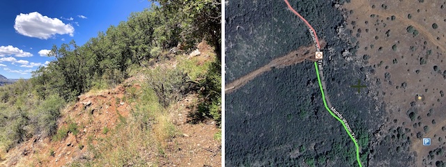
At the two mile mark, I reached FR 153A (east). I should mention, here, that FR 153A is a loop anchored at both ends by Schnebly Hill Rd. The west end of FR 153A is what looks like a campground just across Schnebly Hill Rd. from the vista.
Just past a small wash, the road splits: left is the start of FR 9494F; right is FR 153A. I followed FR 153A southwest for ¼ mile to the microwave relay. Though not officially designated, the road continues 200 yds., down to Schnebly Hill Trail #158. That is where I would have started up Munds Mountain had I not already been hiking a couple of miles. I doubled back, then started south on FR 9494F.
The Munds Park area has had some rain this monsoon, so I was expecting better flower coverage than I found. It was poor. Sulphur buckwheat were most common, with scraggly clusters. Toadflax penstemon were next most common; they were tiny and hard to photograph. (As evidenced by the blur.) So, most of Schnebly Hill’s color was provided by the red rocks of Sedona. Fair trade. 😁
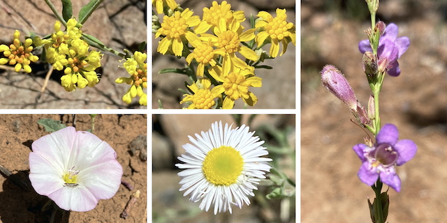
Top Row: sulphur buckwheat, Richardson’s bitterweed, toadflax penstemon.
Bottom Row: field bindweed, spreading fleabane.
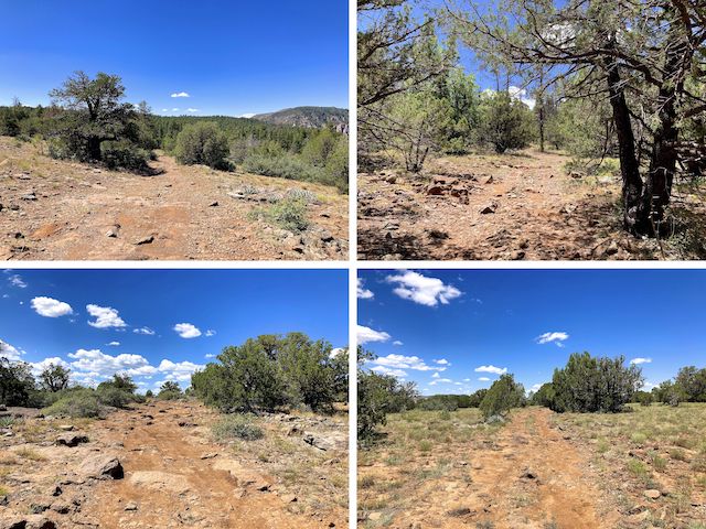
Like other Schnebly Hill roads, FR 9494F was rough. But hiking was no problem. All across Schnebly Hill, the sitting shade was high quality. So was reception on my iPhone, which was 3-4 bars, even when not line-of-sight to Sedona. After a mile on FR 9494F, I reached the junction near Oak Tank. A sign said east was FR 9495F, so I turned west on what I believe was still FR 9494F. Munds Mountain appears.
There was no shade on the next rough mile to Committee Tank. If you can get your vehicle in, Committee Tank is where you should park to hike Munds Mountain Trail #77. Follow the tank’s fence south for ¼ mile to the Hot Loop Trail sign. Follow the gabions down, west for 250 yds. At the saddle, Munds Mountain Trail #77 is left; I turned right on Schnebly Hill Trail #158.
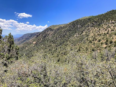
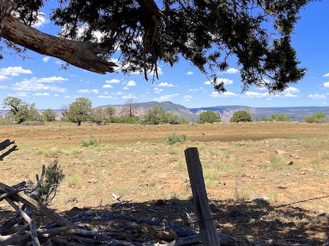
Schnebly Hill Trail #158 climbs a steep 100 ft. from the saddle, then steadily drops as it heads north. There is frequent moving shade. Red rock views regularly appear, particularly Mitten Ridge along Bear Wallow Canyon. In a mile, Trail #158 reaches the path up to the microwave relay. 350 yds. past the path, a 75 ft. wide landslide severed the trail. Even butt scootching around it didn’t look safe. I doubled back.
My earlier scouting paid off, as I easily found my way up to the microwave relay. I then turned north on FR 153A (west), following it 1⅓ miles back to where I started at Schnebly Hill Vista. My wife reported that several vehicles had stopped by, but no Pink Jeeps had driven up from Sedona. Bummer. Still, my non-hiking wife got to see lots of pretty red rocks first hand — a good reward for all of her support. 👩🏻❤️👨🏻
Directions: From I-17, take exit 320 onto Schnebly Hill Rd. If you are driving north, it is the third exit after cresting the climb from Verde Valley. From I-40, it is 20 miles south of Flagstaff. FR 801 is on the left 3.5 miles from I-17. (It is 3.6 miles more on FR 801 to Committee Tank.) FR 153A (east) is on the left 4.0 miles from I-17. (It is 1.3 miles more on FR 153A to the microwave relay.) Schnebly Hill Vista is 5.6 miles from I-17.
GPS File: Schnebly_Hill_Exploration
Distance: 9.34 miles
AEG: 1,073 ft.
Time: 4h 13m
Rumble Video
Vimeo Video
Hiking Schnebly Hill, Coconino National Forest from Preston McMurry on Vimeo.