

The second in my summer series of Prescott area hikes. I’ll be gradually working my west and south. Temps at the 6,800 foot elevation trailhead were nice at 8:00 a.m., but it got toasty as the day progressed, and Trail #284 is a bit exposed. Trail #285 definitely had more shade.
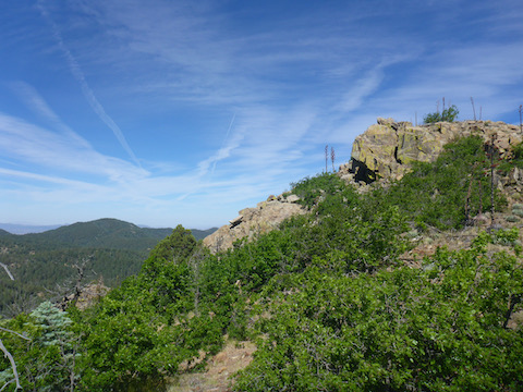
Passed a birder on my way up #285, which was fairly rocky and steep. I did okay, despite being overweight and not acclimated to the altitude. At the saddle, I heeded Yeti’s advice to follow the orange ribbons up Mount Davis. About halfway up, there is a barbwire fence. There is a easy-stepping low-point about 10 yards to the right of the ribbons. The top of Davis is realtively flat, and would make a nice camp spot. There was an old fire ring there. I searched the summit for 20 minutes, but did not find a summit log. I then headed a short distance north to the knoll, where I’d read there were great 360° views — which indeed there were. There was also a geicache & summit log, hidden in a crevice, beneath some rocks, next to a two stone cairn. I ate my first snack: One cinnamon Pop Tart.
I headed back the way I came, down to the saddle, then west up #284 towards Mount Union. When I got near the summit, the breeze on the trail was slight, but I could hear the wind howling 200 feet above as it struck the supports of the signal towers.
I went past the summit, following the access road down a bit, before crossing a gate and descending a steep rocky jeep trail. There were three whazzits — “What is it?” — down there that I has scouted on satellite view. First whazzit turned out to be a old kiddie-sized picnic table. ![]() I went a bit further down, spotting a stop sign between me and whazzit #2, so I continued to whazzit #3, which turned out to be a small platform and trailer. (Probably for mining equipment.) Back up to the second whazzit, I called out several times. No response, so I went by the stop sign to see what was there.
I went a bit further down, spotting a stop sign between me and whazzit #2, so I continued to whazzit #3, which turned out to be a small platform and trailer. (Probably for mining equipment.) Back up to the second whazzit, I called out several times. No response, so I went by the stop sign to see what was there. ![]() I saw a tripod over what looked like shaft, but on approaching turned out to be a fire ring. There was a storage shed, behind which was a smaller building with a plastic container on top. My first though was “chemical toilet”, second was “meth lab”.
I saw a tripod over what looked like shaft, but on approaching turned out to be a fire ring. There was a storage shed, behind which was a smaller building with a plastic container on top. My first though was “chemical toilet”, second was “meth lab”.
Back up the steep, rocky jeep trail. I stopped every couple hundred yards for a few seconds breather / coronary avoidance. When I got to the access road, I sat down for a few minutes and some more Pop Tart.
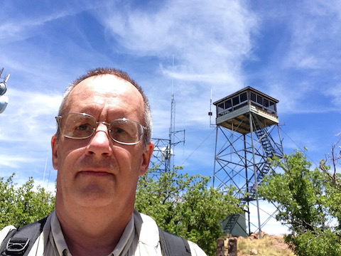
I got up to the Mount Union summit, waved at the tower, then checked out a wooden platform. (I found out later it is a helipad, which I would have never suspected due to a) not having an (H) and b) being really freaking small.) I then went back towards the towers and the lookout waved down to me and invited me up. (I never would have been so forward as to ask.) The wind was continuing to howl as I climbed up the three flights of stairs, which caused some concern, but the tower did not wiggle, and there was no chance of taking a dry dive.
John the Lookout was a really nice guy, and we chatted for about 30 minutes. I mentioned not finding a summit log on the actual summit of Mount Davis, to which he commented that an Indian guru — I heard “Navajo” or “Apache” guru ![]() — had a saying that “When in a mango grove, do not count the leaves: Eat the mango.” That made me think. John the Lookout has travelled all over southeast Asia, many times, causing me to ask “Is that a relative?” about a picture of an Asian man on his desk. It’s actually his guru. I told him my wife is Indonesian and that her father had been a slave laborer on the “Bridge on The River Kwai”, which was a vastly worse experience than the entirely fictional movie classic.
— had a saying that “When in a mango grove, do not count the leaves: Eat the mango.” That made me think. John the Lookout has travelled all over southeast Asia, many times, causing me to ask “Is that a relative?” about a picture of an Asian man on his desk. It’s actually his guru. I told him my wife is Indonesian and that her father had been a slave laborer on the “Bridge on The River Kwai”, which was a vastly worse experience than the entirely fictional movie classic.
I was so engaged in our chat, and John showing me his lookout gear, and enjoying the 100+ mile views — Bill Williams Mountain, the San Francisco Peaks, Four Peaks and the Superstitions were visible — that I forgot to take any pictures. Then I forgot to sign the Mount Union summit log. ![]()
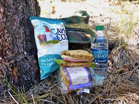
Halfway down #284 to the saddle, I stopped to eat lunch. (The summit picnic area no longer exists.) Then booked as fast as rocky #285 would allow back to the trailhead, passing only three people (one the same birder).
GPS File: Mount_Davis_Mount_Union
Distance: 7.74 mi.
AEG: 2,172 ft.
Time: 3h 24m
Hike Video
Hiking Mount Union & Mount Davis from Preston McMurry on Vimeo.