

When the path of the Loop 202 South Mountain Freeway was finalized back in 2015, I decided I would document the changes at the west end of South Mountain Park, between Pecos Rd. and the Dusty Lane community, adjacent to the Vee Quiva Casino. The freeway will be much longer than the four miles or so I have been recording, 22 in all, first replacing Pecos Rd., then angling along the east side of the power lines next to the Gila River Indian Community, then heading north along the former path of 59th Ave. to I-10.
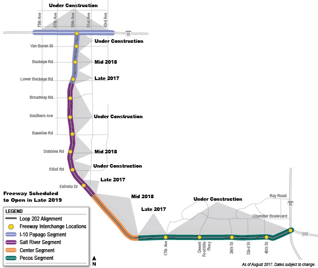
As of August, 2017, ADOT’s Loop 202 Freeway site indicates that the Center Segment, the part I survey, will be complete begin construction by the middle of 2018. See the orange bit below:
Today was my sixth survey hike, the first being in April, 2015. If ADOT’s contractors stick to schedule, I would expect next April’s hike to be the last where I can follow any portion of the intended road bed, as I have so far done. After following the road bed becomes unsafe / illegal, I will instead parallel it. 😇
Once the freeway opens to the public in late 2019, I will drive it, filming with my dashcam, so that what the west end of South Mountain became can be compared to what it once was. 🚙
If you scan through the hike video at the bottom of each of my Loop 202 South Mountain Freeway blogs, you will see that there have already been changes, the two biggest being most of the Dusty Lane community being disappeared, and the other being the construction of a new luxury community adjacent to Center Segment, between Main Ridge South and Main Ridge North. Yes, you read that right: After plowing Dusty Lane and the houses along Pecos Rd., a new community is being put in. 🙄
I figured not much had changed along my survey route, on construction sections 8 and 9 (the Center Segment), between Dusty Lane and Pecos Road, so rather than photograph the unchanged state of each of 28 waypoints, I decided instead to document all the decrepit ranches, and other features, in the valley between Main Ridge South and Main Ridge North.
That turned out to be a wise decision because, indeed, nothing had changed freeway-wise in the Center Segment. Not one pebble had been moved.
As I said earlier, Center Segment construction is due to begin in mid-2018, but as my video shows, I was hiking under the mistaken impression the Center Segment was supposed to be done by mid-2018. Meaning, it should have been well under way. It was good I was skeptical.
At one time, there were at least four ranches / mining camps, comprising at least a dozen buildings, in the valley.
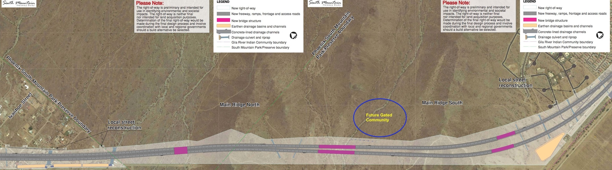
There’s a third ridge between Main Ridge South and Main Ridge North. It is unnamed by ADOT because the Loop 202 South Mountain freeway will not cross it. The new development is on the south side of the unnamed ridge; the R.A. Steele ruins at its tip, and the other ranches between it and Main Ridge North.
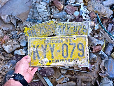
I shot some high vantage point video of the ranches from the unnamed ridge, before checking out a miners’ dump / plain ol’ garbage dump. No new garbage in the dump, but I spotted three 1969 Arizona license plates. Sweet score!
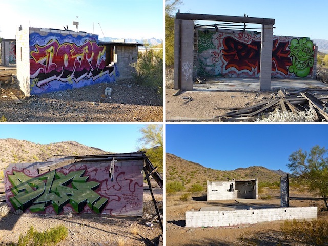
The “Graffiti Ranch” was occupied at least as recently as 1973. (According to initials & dates etched into then wet cement.) In 2015, there were some very nice graffiti pieces on the walls. Six months ago, some throwies & tags had been added, with the same tags over at the “Rock Wall Ranch”. There has always been a lot of garbage & nails strewn about the “Graffiti Ranch” area, which included a decaying wood trailer.
Today, the wood trailer was gone, all the garbage & nails removed, the graffiti on the standing building painted over and the wall knocked down. Also, there are now some folding chairs inside the building. Seems odd that someone would go to the trouble of cleaning the area up, not simply clear it.
A number of ranches, including one across the wash from “Graffiti Ranch”, had indoor plumbing. I’ve found PVC pipe leading from cement foundation into washes, as well as porcelain bathroom fixtures in the washes and along the jeep trails. It looks like the “Graffiti Ranch”, though, had an outhouse, as evidenced by a slit trench.
The “Rock Wall Ranch” had not changed any. It was still burned out, with a solid foundation, the remains of natural stone walls, a stone planter / grill, and much garbage & nails strewn about. The “Rock Wall Ranch” is closer to the Loop 202 South Mountain Freeway than “Graffiti Ranch”, but should be unaffected by construction, as it is still about 100 yds. from the north bound lanes.
On the other hand, the R.A. Steele ruins, which date back to the 1940s, and were occupied as recently as 1982, will go bye-bye, disappearing under those north bound lanes.
The Loop 202 South Mountain Freeway will be on the east side of the power lines which are adjacent to the Gila River Indian Community. Between the rez fence and the power lines, is a power line road. It’s chopped up by uncrossable washes and, where it scales the south slope of Main Ridge North and north slope of Main Ridge South, is very rocky and would require great 4×4 skill. The jeep trail will be there after the freeway is completed, but it still made me wonder how APS would ever maintain the towers on the ridges. 🤔
Once I got to the top of Main Ridge South, I followed the jeep trail east a hundred yards to the luxury development access road. The rugged jeep trail down the south slope of Main Ridge South is still there, but no longer accessible from the top of the ridge due to the development’s entrance, roundabout and decorative walls bisecting it. I suppose APS maintenance could always helo in. 🚁
Six months ago, the development’s access road was dirt. Now it is paved, and has sidewalks its entire length. Heck, I actually saw two women jogging on it. Pending gate installation, a security guard prevents unwanted entry. Even the hot women joggers had to turn around. 🏃🏻♀️
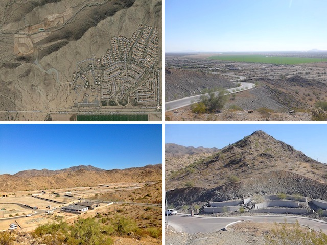
It appears the roads in the development have also all been paved & sidewalked. Perimeter and property dividing walls have all been erected. Construction on three buildings has begun. I hope the prospective homeowners enjoy a freeway serenade, as the devlopment is within a hundred yards of the Loop 202 South Mountain Freeway’s north bound lanes.
Looking south, from my vantage towards Pecos Rd., I confirmed that no work had begun there either. So, rather than descend to Pecos Rd., only to turn around and climb back up Main Ridge South, I headed back across the Valley to Main Ridge North, where I took my customary final, shady, break. (The only shade on the hike other than in the one remaining “Graffiti Ranch” building.)
Hopefully ADOT gets their Tonka Toys out before I do my next survey hike in April! 🚜
GPS File: Loop_202_South_Mountain_Freeway
Distance: 6.32 mi.
AEG: 681 ft.
Time: 2h 48m
Hike Video
Loop 202 Survey Hike #6 (11/8/17) from Preston McMurry on Vimeo.