

Yeager Canyon is a 14-mile long canyon, located on the Mogollon Rim between Dane Ridge and Buck Springs Ridge. Yeager Canyon starts on Rim Rd. at about MP 20, draining north — as do all Rim top canyons. But, unlike most other Mogollon Rim canyons, no other major drainages feed into it. Yeager Canyon’s walls get deeper & steeper as it heads north. 🏞
Buck Springs Canyon is on the other (east) side of Buck Springs Ridge, starting 1½ miles north on FR 137. Buck Springs Canyon drains into West Leonard Canyon, at the tip of Hospital Ridge, after 7 miles. Unlike Yeager Canyon, Buck Springs Canyon never gets deep or rugged, and has parallel decommissioned forest roads for much of its length.
My plan was to hike from the head of Yeager Canyon, north for three miles, then climb out, via Barbershop Trail #91. (If I could find it.) After checking out the old fire guard station at Buck Springs, I planned to loop back to my trailhead via decommissioned FR 9714Z and FR 9714D.
Northern Arizona had storm & flash flood warnings the day before (and after) my hike. On the drive in, Rim Rd. / FR 300 was muddy, even sloppy, the four miles around Baker Butte. Though it got better as we drove east, we creeped the final mile, from FR 321 to FR 137, across the head of Yeager Canyon, as I was checking Rim Road for General Crook Trail marker V51. Third attempt to find it was not a charm.
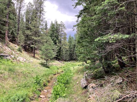
The head of Yeager Canyon resembles a nerve cell. I started down the mild eastern “dendrite” at 9:45 a.m. It was uncluttered, with a mild grade. No flowers. Only mylar balloon of the day. I found two capped segments of 1″ PVC sticking out of the ground. No indication as to their purpose. At the second one, I made a 90° left turn, hiked 50 yds., then made a 90° right, to get back on the low line. 🧭
I reached the bottom of Yeager Canyon at ¾ mile mark, without having to negotiate any final cliff or pour (e.g. Lower Miller Canyon). In the next 2½ miles, I may have ducked one log. I never had to low crawl. No real ankle breaker rocks. No large boulders to scramble. Plenty of bracken fern and corn lily, but no grab & stabs or tripper vines. I wouldn’t say it was smooth sailing, but it was relatively mild.
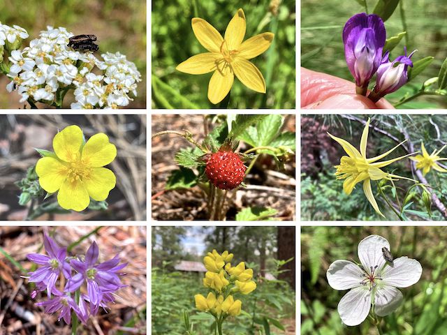
Top Row: Can we get some privacy here!? (western yarrow), timberland blue-eyed grass, Aspen pea.
Middle Row: woolly cinquefoil, Virginia strawberry, yellow columbine.
Bottom Row: ???, goldenbanner, Richardson’s geranium.
Pygmy bluet were the most common flower in both Yeager Canyon and Buck Spring Canyon. I also saw blooming New Mexico locust — one each — in both canyons. (New Mexico locust are a shrub / small tree.) There were scattered maple. No oaks. I did find a cluster of quaking aspen, which I don’t recall in a narrow Mogollon Rim like Yeager Canyon. Given the rain, fungi were surprisingly rare.
I was unsure exactly where — if at all — Cabin Loop / Barbershop Trail #91 crossed Yeager Canyon. I had heard it was indistinct, overgrown. All I knew is that it should be around 3¼ miles into my hike. Accordingly, at the three mile mark, I began scanning for bail points. I saw two animal tracks and several numbered metal tags — 70, 83, 84 — nailed into trees. (No idea …) 🤔
I needn’t have worried: Cabin Loop was obvious, signed, foot trail. (Some of the signs, are modern, others are the old, lowercase, i-shaped blaze gouged out a tree’s bark. The first switchbacked segment climbs 100 ft. in 200 yds. I then headed north on a level, decommissioned, jeep trail. In 350 ft., a tree blocked the road. Cabin Loop continues on the right, heading up 50 ft. in 200 yds. to FR 137.
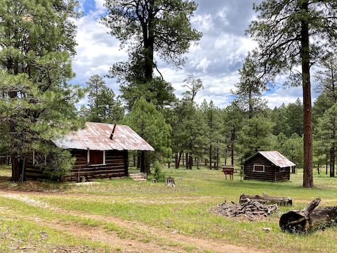
There was a Barbershop Trail #91 sign on the other side of FR 137. I didn’t see where the trail continued, so I followed a ditch down. Buck Springs Cabin is 100 yds down the ditch. It’s actually two cabins. I was hoping they’d be open, but no such luck. Maybe being locked is why they are in such good condition? The larger cabin had gas grill on its porch. No idea if it worked. 🌭
I crossed the creek near the check dam, which had a large pool above, and good flow below. Lower Buck Spring was at the 4-mile mark. The Lower Buck Spring wetland was surrounded by a critter-proof unbarbed mesh fence. For “aspen protection”. Unfortunately, the v-gate was also wired shut. Oh well.
From the Lower Buck Spring v-gate, I spun 180° to pick up FR 9714Z, on the south side of FR 161. FR 9714Z is blocked for vehicle use by boulders. I walked right through. I could have easily enough hiked along the edge of the Buck Springs Canyon prairie, but I was enjoying the shade 50 yds. inside the treeline. Having been thwarted at Buck Springs Cabin, I took advantage of the shade to have lunch.
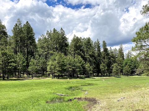
The Buck Springs Canyon prairie wetlands are protected by two fenced enclosures. I skipped by the first on FR 9714Z, which edged up to the prairie at the 4½ mile mark. At the 4¾ mile mark, FR 9714Z entered the second enclosure. The gate was unlocked, so in I went. I was nonplussed to find the gate at the south end was wired shut. I worked my way along the fenceline to a collapsed section, stepped across, then rejoined FR 9714Z.
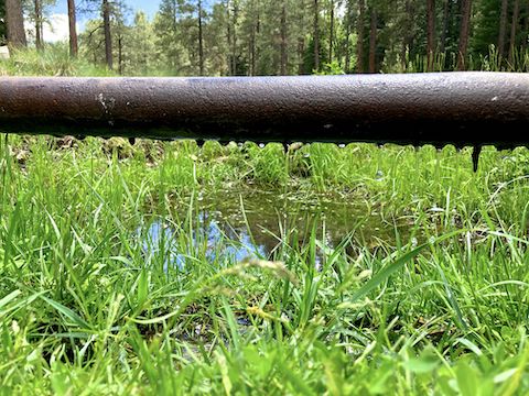
I found Upper Buck Spring at the 5⅓ mile mark. The spring pipe was dripping fast enough to feed the Buck Springs Canyon creek. Just past Upper Buck Spring, FR 9714Z switched to the west side of prairie. I lost the anyways faint road soon thereafter. No problem, it was a mild bushwhack up to FR 137, just past the six mile mark. It was mid-afternoon, so I skipped my planned diversion to the Holder Cabin site.
I completed my Yeager Canyon – Buck Springs Canyon hike after nearly 7½ miles (nine by my count, due to wandering). If you want an introduction to Mogollon Rim canyon crawling, it would not be a bad choice. 👍
Directions: From Phoenix, head north on I-17 to Camp Verde. Take exit 287, east onto AZ-260. In 33.7 miles, turn left on AZ-87. In 2.6 miles, turn right onto Rim Rd. / FR 300. Just past MP 20, turn left on FR 137. In 0.3 miles, park in the pullout formed by FR 9714C.
GPS File: Yeager_Canyon_Buck_Springs_Canyon_Loop
Distance: 8.91 mi.
AEG: 652 ft.
Time: 3h 59m
Rumble Video
Vimeo Video
Hiking Yeager Canyon & Buck Springs Canyon from Preston McMurry on Vimeo.