

Quien Sabe Draw is a small canyon on the Mogollon Rim, between Turkey Pen Ridge and Fred Haught Ridge. Only 2½ miles long, Quien Sabe Draw has two upper branches that both start off FR 719. The branches join after 1¼ miles. Quien Sabe Draw continues for another 1¼ miles, emptying into Bear Canyon. (One of at least five Bear Canyons in Arizona: The nearest being only thirteen miles southeast in the Apache-Sitgreaves National Forest.)
The last five years, I’ve averaged seven or eight Mogollon Rim hikes. In 2025, before today, I had only done two. I was expecting it to be sunny in the morning, partly cloudy midday. (Making for nice contrast photos.) Instead, it was totally overcast, and 60°. My wife commented on how cool it was.
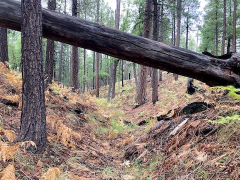
I meant to park a couple hundred yards down FR 719, at the head of the east branch of Quien Sabe Draw. Instead, I parked right at FR 95. As a result, I walked past the east branch. I was halfway down the west branch before I realized what I had done. I thought about turning back, but ah, what the heck. It counts. The west branch, at least, would be a good “Intro To Canyon Crawling”.
Today did not have a large quantity of flowers, but there was good quality & variety. There were mullein and Wheeler’s thistle along FR 719. Alpine false springparsley, yarrow, and Richardson’s geranium in Quien Sabe Draw’s west branch. Nuttall’s linanthus, silver lupine, Richardson’s bitterweed, fleabane, and paintbrush along Cabin Loop, and down Quien Sabe Draw.
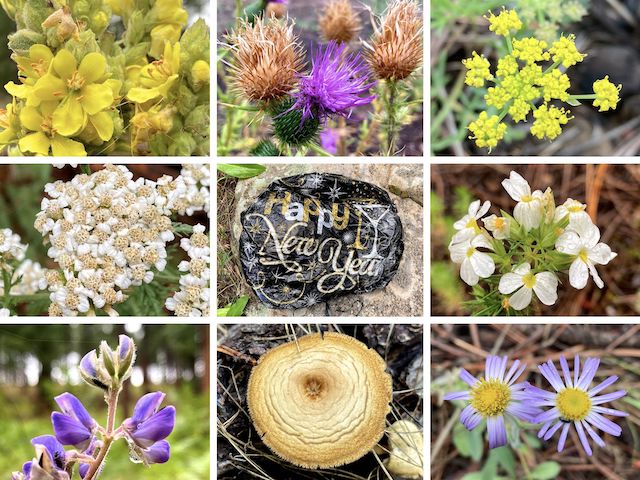
Top Row: mullein, Wheeler’s thistle, alpine false springparsley.
Middle Row: yarrow, mylar balloon, Nuttall’s linanthus.
Bottom Row: silver lupine, mushroom, fleabane.
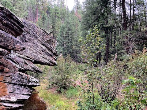
As I cruised along Cabin Loop, I noted that at least the bottom 200 yds. of Quien Sabe Draw’s east branch were easy travel. (I cannot attest to the upper part of the east branch.) Near Quien Sabe Spring — which I could not locate — I began to follow Cabin Loop out of the Quien Sabe Draw. Instead, stay left along the dry creek bed. A decommissioned road — FR 9722W — is on the dry creek’s west bank.
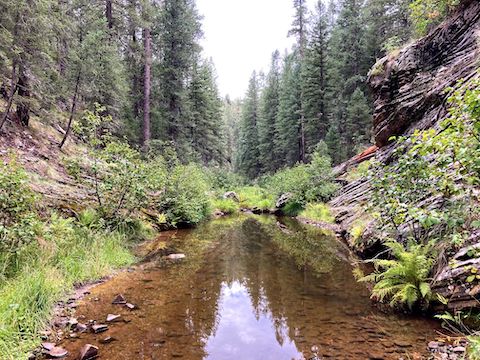
FR 9772W ends at FR 719. Quien Sabe Draw gets rocky, but travel is not difficult. No part of Quien Sabe Draw had tangled vegetation or serious deadfall. Bailing from any part of Quien Sabe Draw, and via either side, would be trivial. Despite photos, I averaged 45 minutes / mile the lower two miles of Quien Sabe Draw. Looking up & down Bear Canyon, it appeared to be smooth sailing.
Bear Canyon was either rocks, rocks hidden in grass, tangled vegetation, pools, or some combination thereof, all the way to the FR 95 washout. High vegetation can throw you off balance. Low vegetation can trip you, or hide ankle breaker rocks. Both could be poisonous. I have no idea what poison ivy or poison oak look like, so I try to avoid all vegetation as much as possible.
To avoid Bear Canyon, loop back via FR 719, Cabin Loop, or the other branch of Quien Sabe Draw.
The plants I could identify in Bear Canyon included orange wallflower, yellow coneflower, alpine leafybract aster, Columbia monkshood, and red cinquefoil. The ends of several tree branches were encased in webs of the type spun by fall webworm or tent caterpillar. (Both moth species.)
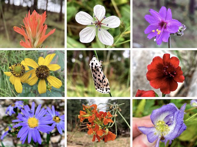
Top Row: paintbrush, Richardson’s geranium, linearleaf four o’clock.
Middle Row: yellow coneflower, leopard moth, red cinquefoil.
Bottom Row: alpine leafybract aster, orange wallflower, Columbia monkshood.
I spotted no bail points in cliff-bordered Bear Canyon. It took me 55 minutes to hike ¾ mile to the washout. A corrugated metal culvert marks the washout (see top & below). The washout is 30 ft. deep, but very steep, with loose sides. I didn’t relish climbing up it. Instead, I walked beside the crushed culvert to it’s far end. To the right, there is a use trail up, through more vegetation. Easy peasy.
From the washout, I zipped along FR 95 back to my FR 719 trailhead.
Quien Sabe Draw and (this) Bear Canyon were the 35th and 36th Mogollon Rim canyon’s I’ve hiked.
Directions: From Phoenix, head north on I-17 to Camp Verde. Take exit 287, east onto AZ-260. In 33.7 miles, turn left on AZ-87. In 2.6 miles, turn right onto Rim Rd. / FR 300. Just past MP 13, turn left on FR 95. (Any FR 95 closure signs you see do not apply to this drive.) In 3.8 miles, turn left onto FR 719, and park.
GPS File: Quien_Sabe_Draw
Distance: 7.61 mi.
AEG: 566 ft.
Time: 3h 23m
Rumble Video
Vimeo Video
Hiking Quien Sabe Draw, Mogollon Rim from Preston McMurry on Vimeo.