

Heading east from Dewey, this is the 9th segment of General Crook Trail.
In 1871, General George Crook surveyed a supply road west from Fort Apache, Arizona, across the Mogollon Rim to Camp Verde, then on to Fort Whipple in Prescott. The General Crook Road was built in 1872. The Army used the road until 1896, and civilians until 1928, when Rim Road replaced it. 🐴
No General Crook Trail resource agrees on the exact route followed by his troops: I am following the chevrons nailed into trees by the Boy Scouts when they retraced the trail in 1976. (The Scouts also planted 24″ high, 4″ diameter, mileage posts every mile, many of which no longer exist.)
Driving in on Rim Road, there was little construction activity, so no real delay. (At least not on Tuesday.) Turning south at the FR 34 intersection, the way was blocked by some “nearby fire” signs. (Presumably for the Pius Fire, which was well north.) I turned around, and decided to try FR 9354 instead. FR 9354 was not bad at all and, better yet had no signs blocking my way further west on Rim Road.
It took me a minute to figure out where General Crook Trail continued east of FR 208L, as it was hidden behind a small pile of brush, and the carsonite sign had fallen over. After that, and all the way to Rim Top Trailhead, the General Crook Trail was clearly defined. I did briefly miss a few turns, but that was my fault, as I was scanning the surrounding terrain for mile markers and other interesting things.
The attached GPS file is the true General Crook Trail route from Promontory Lookout to Rim Top Trailhead. It does not include any of my wrong turns or wanderings. That is why my mileage for the day (11.43 mi.) is greater than this segment’s routed mileage (9.76 mi.). 🧭
This General Crook Trail segment is 100-200 yds., and slightly downhill, from Rim Road. After ¾ mile, the trail turns south, away from Rim Road. It spends the next 1¼ miles sometimes co-located with Carr Lake Trail #412, sometimes not. All the intersections are thoroughly signed. Some trees had a diamond blaze, which I assume is for the Carr Lake Trail #412. Just follow the chevrons.
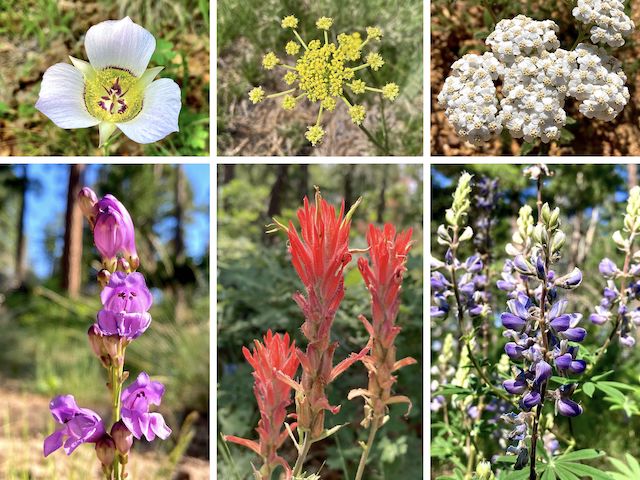
Top Row: doubting mariposa lily, alpine false springparsley, western yarrow.
Bottom Row: wandbloom penstemon, paintbrush, silver lupine.
I found my first General Crook Trail mile marker, V63, exactly where previously indicated. It was quite a relief from the confusion of the prior segment, from FR 115 to Promontory Point. V63 gave me a known point to measure from. V64 should be a mile ahead, give or take a 50-100 feet. It wasn’t. (Neither the U.S. Cavalry, nor the Boy Scouts, having had access to GPS.)
V64 was where it was previously indicated, but it was only ¾ mile beyond V63, not quite two miles into this General Crook Trail segment. On the left (north) — just past the fourth, and final, Carr Lake Trail #412 sign at FR 9350C — there is a sinkhole covered with bracken fern, and ringed by a rocky caldera. Like much of the previous mile, it’s shady. 🤗
Just past the sink hole, on the south side of the General Crook Trail, is a grassy bowl that is marked on the topo as a “gravel pit”. I dunno. Maybe when they were building Rim Road a hundred years ago? After the gravel pit is the only “climb” of the day — all of 40 ft. Overall, this segment only has 235 ft. accumulated elevation gain (AEG), while losing a net 370 ft.
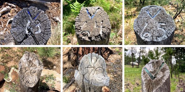
Top Row: V63, V64 and V65.
Bottom Row: V69, V70 and V71.
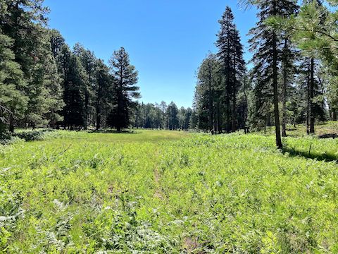
On the other side of the “climb” is a meadow — flanking dry Woods Canyon Creek — known as Hole-in-Ground. At the southern tip of the meadow, at the intersection with Drew Canyon Trail #291, I found General Crook Trail mile marker V65 — a full 1¾ miles from V64. And 2½ miles from V63. Egads. At least I was enjoying my hike.
Carr Lake Trailhead is a little over four miles into this General Crook Trail segment. It has a pit toilet, so it would be a good turn around point if you don’t have a shuttle like I did. After Carr Lake Trailhead, I crossed newly paved Rim Road, “Speed Limit 25”. LOL. Sure. Double that with the new pavement. Play Frogger on holiday weekends! 🐸
Overall, flower coverage was light. Wandbloom penstemon were most common, and scattered all along this General Crook Trail segment. I only found silver lupine in one location, but it was a dense patch. Besides the species shown above & below, the other high country flowers I found included red & yellow pea, silky evening primrose, and coneflower.
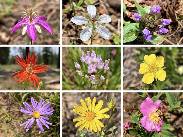
Top Row: pineywoods geranium, Richardson’s geranium, common self heal.
Middle Row: Mexican silene, Geyer’s onion, woolly cinquefoil.
Bottom Row: alpine leafybract aster, hairy golden aster, Wood’s rose.
I started finding double chevrons — one the normal cream, the other orange. According to a sign, orange marks the “preferred travel” route, while cream marks the “original” route. (I assume original Boy Scout route, not General Crook, as the terrain choices don’t make tactical or 19th century transportation technology sense.) Other than near Baker Lake, I’ve only ever seen cream-colored chevrons.
The previously indicated location of V69 was 5½ miles into this General Crook Trail segment. I spent 15 fruitless minutes searching for it. I actually found V69 at the 7⅔ mile mark, 200 ft. off trail. V65 is precisely four miles prior to V69 — which is itself exactly one mile before V70. Therefore, I believe V65 is in the correct location, while V64 and V63 are mis-measured. I never did spot V66, V67 or V68. 🤷🏻♂️
East of Woods Canyon Rd., General Crook Trail frequently crisscrosses FR 9300. There were several sections of exposed bedrock, but I never saw any wagon ruts. I passed by three fenced enclosures, presumably for aspen protection. The first was full of dead trees. I found V71 where previously indicated, one mile on the dot from V70. Rim Top Trailhead, and its nasty pit toilets, were 250 yds. east.
Promontory Lookout Directions: From Phoenix, head north on AZ-87, the Beeline Highway, into Payson. Turn right on AZ-260. In 29 miles, after cresting the Mogollon Rim, take the first left onto Rim Rd. / FR 300. In 250 yds., on the right, is Rim Top Trailhead. Continue past it for 9.4 miles to the t-intersection. Turn left. (Right is FR 34 to Winslow.) After 2.3 more miles, Promontory Lookout is on the right.
Rim Top Trailhead Directions: Double back 11.7 miles, almost all the way to AZ-260.
GPS File: General_Crook_Trail_V62_V71
Distance: 11.43 mi.
AEG: 314 ft.
Time: 4h 23m
Rumble Video
Vimeo Video
Hiking General Crook Trail: V62-V71 from Preston McMurry on Vimeo.