
 with a fallen trail post. By this point I had learned not to handle the fiberglass posts -- splinters! -- so I nudged it into place with a stick.")
Heading east from Dewey, this is the 14th and final segment of General Crook Trail.
In 1872, General George Crook‘s troops built a road from Fort Apache, Arizona, west across the Mogollon Rim to Camp Verde, then on to Fort Whipple in Prescott. “Vanished Arizona: Recollections of the Army Life of a New England Woman“, by Martha Summerhayes, contains a detailed description of travel on the General Crook Trail in the 1870s. 🏜
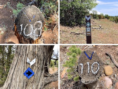
Originally, the General Crook Trail’s mileage was scratched in trees and rocks. In 1976, the Boy Scouts replaced the missing rocks and fallen trees with a 24″ high logs, 4″ diameter, with the mileage etched into the angled top, and painted white. Many of which are now also missing. I am following chevrons nailed into trees. Other trail markers I’ve found include by gabions, cairns, ribbons and fiberglass posts.
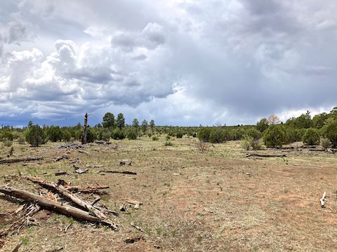
On our drive east along AZ-260, it started raining as we neared the top of the Mogollon Rim. The rain got particularly heavy in Heber-Overgaard. I got ahead of the rain by the time we reached FR 124 trailhead at ZB Draw. Hoping the rain would slide south, along the Rim, rather than east along the General Crook Trail, I headed out.
In 250 yds., on the right, was a cluster of trees where I expected to find General Crook Trail mileage marker V107. (Based on V106 supposedly being west of FR 124.) After searching for five minutes, no joy. A lot of the mileage markers have gone missing over the last 50 years. Burnt, knocked down, buried in brush, who knows? 🤷🏻♂️
General Crook Trail bends left, then turns sharply south, along the rim of Day Wash. Following foot trail when I couldn’t see a chevron ahead, I briefly wandered off track. Not for the last time either. I crossed Day Wash after ½ mile. There’s supposed to be a vehicle wreck in Day Wash, but I couldn’t find it. Just a pile of non-vehicular random metal garbage.
When the General Crook Trail reaches FR 124B, at the 1-mile mark, I saw two chevrons on the south side of the road: The first followed the foot trail; the second, 50 yds. away, led off who knows where. Maybe Decker Tank? Anyway, turn left on FR 124B. It has chevrons as well. In under a half mile, V108 is obvious on the left. Feet past V108, follow chevrons left, off FR 124B, northeast along foot trail.
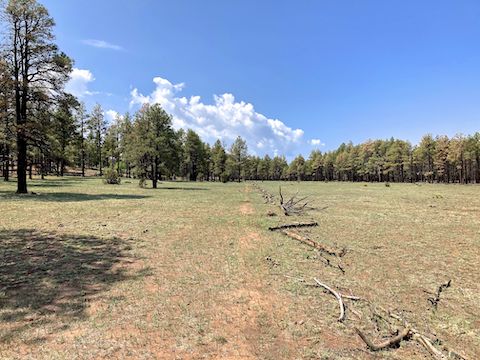
The next mile of the General Crook Trail is along the west bank of an unnamed wash. The opposite side is dense with young gambel oak. (I assume from post Rodeo-Chediski Fire reseeding.) The trail posts were widely spaced so, following the foot path, I missed another turn. No big deal, but it explains why my mileage for the day was two miles longer than this segment’s official 7.17 mile distance.
After crossing the unnamed wash at the 2-mile mark, roughly where V109 should be located, the foot path turns east. Crossing FR 107, General Crook Trail gets back on decommissioned jeep trail. At the 3-mile mark, it crosses Willow Wash, which has an interesting flat stone bottom. Mile marker V110 is obvious, on the left, a third of a mile past Willow Wash.
I had 3-bar Verizon reception everywhere I checked along this General Crook Trail segment — except only 1-bar at FR 139 — probably due the cell tower cleary visible a quarter mile north of the Willow Wash crossing.
The General Crook Trail crosses Bagnal Wash. The jeep trail splits 200 yds. later, at the 4-mile mark. The split is where I saw my first blue White Mountain Trail System diamond. Go right. I felt occasional rain drops. In a quarter mile there is a cattle tank. It was maybe 25% of capacity. Mile marker V111 should be before Williams Ranch, but I did not find it.
The General Crook Trail used to pass through the valley now occupied by Williams Ranch. (Which is fenced and has security cameras.) Instead, turn left, north on FR 9805E / Williams Rd. At the corner of the ranch fence, turn right on another jeep trail, continuing to follow the fence. Despite now steady drizzle, I could see the hamlet of Clay Springs in the distance. 🌧
I was not expecting much flower-wise, so the day turned out better than I hoped. Besides the flowers top & below, I also spotted yellow salsify (Tragopogon dubius), alpine false springparsley (Cymopterus lemmonii), American vetch (Vicia americana), and what may have been James’ catseye (Oreocarya suffruticosa). Not much, but better than expected, and much better than this Spring in Phoenix.
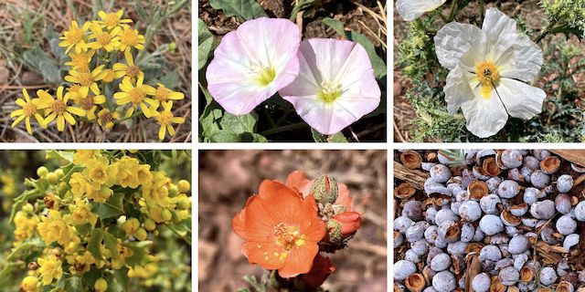
Top Row: New Mexico groundsel, field bindweed, southwestern prickly poppy.
Bottom Row: red barberry, scarlet globemallow, juniper berries. (All the juniper had nice berry carpets.)
At the 5-mile mark, the General Crook Trail passes through an ungated gate. (If that makes sense?) It was now full on raining. I began looking for a good tree to shelter under, so I could don my trash bag “raincoat”. At 5⅓ miles, I split left on Ricochet Ranch Rd. In 2014, mile marker V112 existed, unpainted and well worn. After searching for fifteen minutes, it joined the growing list of things I did not find. 🤦🏻♂️
Road Tank is 150 yds. past V112’s former (?) location. Road Tank is where it stopped raining, about 1:00 p.m. At Road Tank, the road splits three ways: General Crook Trail follows the least travelled right split. As always, following the chevrons. Heading east the General Crook Trail’s final mile, I found neither V113 nor V114.
I’ve now completed the General Crook Trail, Black Canyon Trail (2023), Maricopa Trail (also 2025), and C&O Canal Towpath (2024). I should be picking up my final two segments of the Prescott Circle Trail this summer. What should my next project be?
ZB Draw Directions: From Phoenix, head north on AZ-87, the Beeline Highway, into Payson. Turn right on AZ-260. In 62.3 miles, just past AZ-260 mile marker 315, turn right onto dirt FR 124. Park wherever.
Cottonwood Wash Directions: Continue east on AZ-260. In 5.6 miles, you will see a white-on-brown FR 139 sign. Turn there. Park at the dirt loop 100 yds. down FR 139.
GPS File: General_Crook_Trail_V107_V114
Distance: 9.22 mi.
AEG: 461 ft.
Time: 3h 36m
Rumble Video
Vimeo Video
Hiking General Crook Trail: V107-V114 (the end) from Preston McMurry on Vimeo.