

I was going to hike Cunningham Loop Trail #316 last week. I only made it to Gold Canyon. I figured after being rear-ended by a white Ford F-150 (of course), it would be best to head over to the dealer to have my SUV checked, rather than continue schlepping out to southeastern Arizona.
This week, I not only made it past Gold Canyon, but across the San Carlos Apache Reservation, through Pima and Safford, and all the way to Cunningham Trailhead on the west slope of Mount Graham. Yeeee-HAH! 🥳
Despite leaving home at 5:30 a.m., with several pit stops along the way, I did not start hiking until 10:45 a.m. I wish I was riding, rather than driving, as the views along AZ-366 were spectacular!
Cunningham Loop Trail #316 can be hiked from either the Cunningham Trailhead or Grant Hill Trailhead. It makes no difference in distance, or elevation gain, where you start. Doing the full trail is about 8.1 miles and 1,050 ft. AEG (accumulated elevation gain). Cunningham Trailhead is about 8,900 ft., while Grant Hill Trailhead is about 9,100 ft. elevation. The trail maxes out at around 9,400 ft. elevation. Other than crossing Grant Creek, the gain is gradual and barely noticeable, even for a flatlander like me. 😉
Old forest roads make up 90% of the mileage on Cunningham Loop Trail #316: On the Lower Trail, FR 4538 and FR 4539; on the Upper Trail, FR 4535 and FR 4541. All have been closed to traffic for quite some time, and are in the process of returning to nature. The trail surface varies from hard pack, to tree litter, to grassy. The only rocky parts are crossing Grant Creek.
Hiking a half loop of FR 4535 and FR 4538 from Cunningham Trailhead would be 4.5 miles ad 650 AEG. Hiking a half loop of FR 4539 and FR 4541 from Grant Hill Trailhead would be 3.7 miles and 470 AEG.
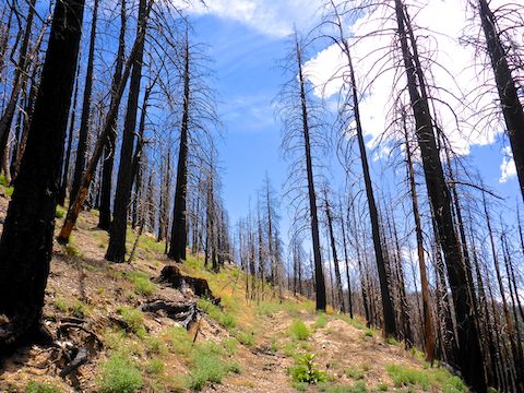
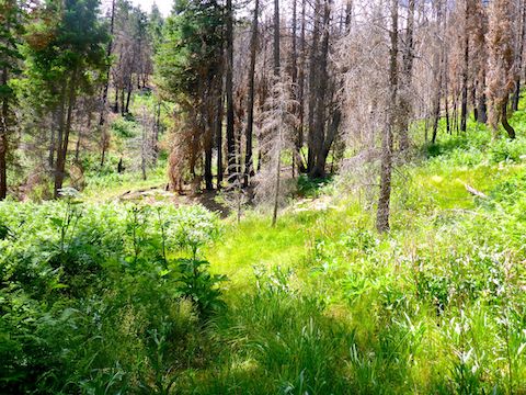
2017’s Frye Fire did a number on Mount Graham, burning over 48,000 acres. Subsequent flood damage has eroded gullies across Cunningham Loop Trail #316 in multiple spots. I’ve heard there are stinging nettles in some of the gullies, but I did not encounter any grab & stabs.
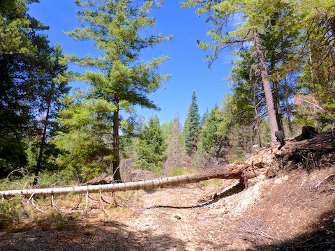
From Cunningham Trailhead, I walked back east on AZ-366 for 200 yds, then turned north onto FR 4538. The forest road is gated against vehicles, but was easy to walk around. I could see fire damage here and there, but Trail #316 started in shade and healthy pine. At .40 miles, the Upper Trail splits left, the Lower Trail right. The trails basically parallel each other, with the Upper Trail being approximately 200 ft. above the Lower Trail. Even with vegetation thinned by heavy fire, they are usually out of sight of each other.
At the intersection, I went left, hiking clockwise. I figured by doing the Cunningham half of the trail clockwise, and the Grant Hill half counter-clockwise, I would do both Grant Creek crossings downhill. As I was expecting both crossings to be bushwhacks, I sure didn’t want to be fighting brush up a steep slope! ✋
After the trail split I started encountering occasionally heavy Frye Fire damage. I have no firefighting experience, but I’ve been interested in wildfire since the Granite Mountain Hotshots perished on Yarnell Hill in 2013.
One of the things I’ve noticed on my hikes through old wildfires is that even though a burn area may encompass some number of acres, what is actually burnt in that area varies from moonscape all the way to not at all. In other words, fire hopscotches around, varying with wind, topography, type of fuel, etc. Also, brush, shrubs, flowers & groundcover recover much faster than even small trees. Today, on the FR 4535 portion of the Upper Trail, it was a 200 yds. of burn area, followed by 100 yds. of healthy trees, all the way to Grant Creek.
2.3 miles into the hike, I arrived above Grant Creek, where I found a trail sign that seemed to indicate I should descend to the creek. (That sign coincided with the route I had downloaded from HikeArizona.com.) I was expecting it to be a bushwhack, and it did not look like anything more than some bent brush. Certainly not a purpose-built trail. Meanwhile, though somewhat overgrown, FR 4535 continued and seemed more obvious. So, I followed FR 4535. 🧭
It ended in a ¼ mile. Totally disappeared. Due to fire damage, I could see the far side of Grant Creek, and there was no obvious trail of any sort on, above or below the 9400 ft. contour. Rather than double back to the wood sign, I headed down.
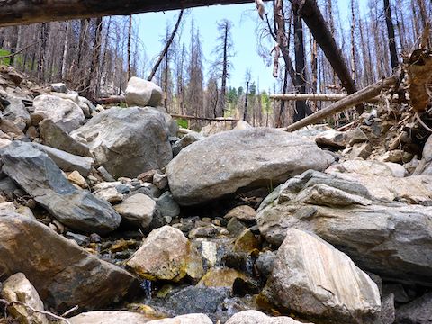
The slopes of Grant Creek have only a moderate amount of brush, but are steep with quite a bit of deadfall and very loose soil. At least it was only 200 ft. down.
The effects of heavy post-Frye Fire erosion were obvious in Grant Creek. It was very rocky, with quite a bit of deadfall. It took me 30 minutes to canyon crawl a ⅓ of a mile. On the positive side, Grant Creek had good flow even though the first rains of the summer monsoon had yet to arrive. 🌤
On the east bank of Grant Creek, opposite the bottom of the FR 4535 bypass, I connected to the Lower Trail. A ¼ mile east of Grant Creek, FR 4539 was cut in half by a weed-choked gully. It was 1:30 p.m. I calculated it would take me two hours to hike the FR 4539 / FR 4541 half of the “figure 8”, plus another 90 minutes doubling back to Cunningham Trailhead on FR 4538. I had promised my wife I would be back around 3:00 p.m., so I bailed.
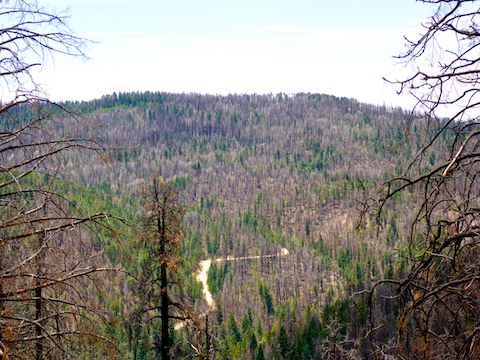
From the signed bypass intersection on what remains of the east end of FR 4538, it is 1.6 miles back to the FR 4535 split. The old jeep trail crossed a number of small gullies, gradually eroding their way upslope with each passing monsoon. There were good-size patches of grass, weeds & other small greenery surrounding each gully. One grassy area even had a seep. (An area where water leaks up out of the ground, forming small puddles.) All the gullies were easy to cross.
There was also more shade on FR 4538 than there was 200 ft. upslope on FR 4535, and that was despite the afternoon sun, which rotated to Mount Graham’s western slope. The shade was welcome, despite the temperature being only 72℉, as I had gotten burnt pretty good hiking through the Frye Fire burn area. Burnt from the sun, that is. 😁
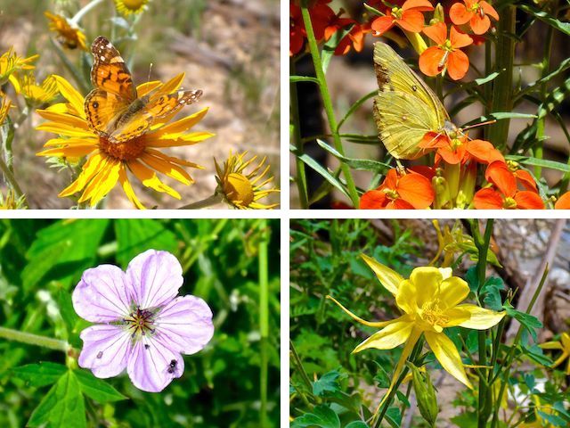
Finally, a word about flowers: The coverage was very light. I’d seen some penstemon on the drive up AZ-366, but none on Cunningham Loop Trail #316. On the other hand, several patches of Western Wallflower were a gorgeous tangerine orange. There were about a dozen flower species overall. Also, I saw about a half dozen butterfly species, including four on just a single cluster of Western Wallflower!
Directions: Safford, alone, is a 3-3.5 hour drive from Phoenix, whether you take US-60 / US-70 across the San Carlos Apache Reservation, or take I-10 through Tucson and Willcox. Either way, you will find yourself on US-191 (formerly the “Devil’s Highway”, US-666). Just south of Safford, split west onto AZ-366. From US-191, it is ~23.5 very twisty miles to the Grant Hill Trailhead, and 2.1 more (or 25.6 total) to the Cunningham Trailhead. AZ-366 turns to car-drivable dirt a half mile before Grant Hill. If you mind your speed, it should take about an hour to drive from US-191 to Cunningham Trailhead.
GPS File: Mount_Graham_Cunningham_Loop_316
Distance: 6.43 mi.
AEG: 757 ft.
Time: 2h 46m
Hiking Video
Hiking Cunningham Loop on Mount Graham from Preston McMurry on Vimeo.