

I originally meant to explore Big Stick Mine last year, on the same day I explored the adjacent Weepah & Homestake Mines. But I ran out camera battery as there was so much cool stuff to see, particularly at the Homestake Mine, which had a very long tunnel. So, I bookmarked my Big Stick info, for a future mine exploration.
That was supposed to be last week, but I could not collate my notes soon enough, ending up doing a ‘locals hike’ up the Marcos de Niza Trail at South Mountain, in Phoenix, as a last second alternative.
Big Stick Mine is also known as the Portland Mine, Broken Stick Mine and, in the early 1980s, when it was owned by A.H. Little, as the Little Margie Mine. ⚒️
Big Stick Mine consists of 12 unpatented claims, in a group of 62, along the Santa Maria River in the Crosby Mining District of western Yavapai County. Big Stick was staked in 1936 and operated until 1942. It’s primary mineral was gold and silver, with some copper and lead.
Some folks took a look at reopening Big Stick Mine in 1958, but it wasn’t until the early 1980s, under A.H. Little, that operations briefly resumed.
Big Stick Mine most recently shut down in 1984, in typical mining fashion, amongst death & financial shenanigans. 💸
It was a chilly 37℉ when I arrived at the trailhead just west of US-93 at 8:00 a.m. I had thought about driving the jeep trail all the way to the Santa Maria River, but wanted to scout it on foot first. Good thing I did.
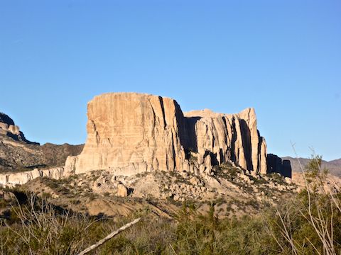
The jeep trail climbs an alternately sandy, rocky & broken 150 ft. to a saddle over looking Black Canyon Wash, Shiprock (not the Navajo one), Ives Peak and the rest of Arrastra Mountain Wilderness. Down to Black Canyon Wash, the jeep trail is similarly difficult. An actual Jeep, or a Ford F-150, with 4×4 would have no problem, but it is a bit beyond a stock AWD SUV. ⛔️
At the bottom, the jeep trail turns north, paralleling Black Canyon Wash. The next two miles are actually pretty smooth dirt surface. If I could get my Acura RDX up & down the saddle, I could drive that two miles, easy peasy.
At 2.8 miles, I turned west off the jeep trail, to check out a whazzit I had spotted on satellite view. Turned out there was nothing there, other than some old hunting / camping fire rings, and associated detritus.
Back on the jeep trail, I turned northeast, up towards two cuts I had seen on sat view. Along the way I found a prospect marked by a wood pole, supported by a cairn. Between the two small cuts, hidden behind some creosote, I found an adit. The adit was marked with aluminum claim tag #20771. The adit only went in a few feet; if it ever went further, it was filled with collapse. 😕
I then got on an old trail that parallels the jeep trail towards Homestake Mine. In several places, the foot trail was lined. or reinforced, with a smal stone wall. In other places, I had to dodge creosote or barrel cacti that had grown up in the middle of it over the past 60-80 years. Where the foot trail crossed a wash, there was what looked like a collapsed foot bridge. In another location, I found several parallel logs, set flush and perpendicular to the foot trail. One of the logs had a wedge shaped spike nail. I wonder if the ‘foot trail’ was once an ore cart track? 🤔
At Homestake Mine, the only thing that was obviously different was the shower shack, with the porcelain toilet, had flopped over on its side. Everything else looked just as decrepit as before, and the adit was still open.
After checking up on Homestake Mine, I doubled back towards Big Stick Mine. As I headed west on the jeep trail, I could see Weepah Mine across the Santa Maria River, which had flow audible from 200 yds. away.
Most of Big Stick Mine is located in an area 100 yds. wide by 250 yds. long, on the bluff between the jeep trail and the Santa Maria River. The two exceptions are an inclined shaft a ¼ mile south of Homestake Mine and the bits at Black Canyon Wash’s confluence with the Santa Maria River.
Big Stick Mine shaft #1 was wide open, with no obstacles, but was 60°, so I did not even contemplate making entry. Not without backup & climbing gear. I could not see the bottom. 🔎
The main 100 x 250 yd. Big Stick Mine area consisted of:
- A small wood shack, with corrugated roof, that was either an equipment shed or explosives locker.
- A miners dump — of course — of rusted old tin cans, none of which were identifiable.
- Various other larger rusty metal bits. The only one I could identify was a smoke stack.
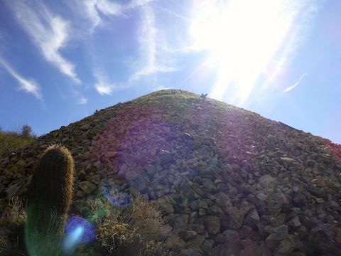
- A pretty good size pile of overburden.
- Two more steeply inclined shafts, both choked with debris. I could see the bottom of shaft #3, which was filled with mud.
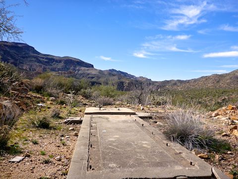
- Three foundations. The foundation across the jeep trail from shaft #2, I first thought may have been for a lift, but the angle was all wrong. It was probably for processing.
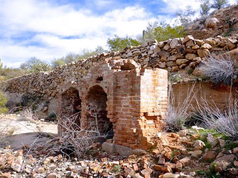
I found Big Stick Mine’s coolest feature near a stone wall I had spotted on sat view: A small brick furnace, still relatively intact, near shaft #3. I spent about 15 minutes taking photos and videos of the furnace’s two arched ovens. 🤗
Since Big Stick Mine’s furnace was near the bottom of the bluff, rather than climb back up to the jeep trail, I splashed through the Santa Mara River’s shallow waters to the confluence with Black Canyon Wash.
In 1982, A.H. Little had an amalgamation mill at Black Canyon Wash. In 1984, the mill had a good deal of equipment (crushers, belts, hoppers, etc.). Now, the mill is just a foundation with a few random bits of hose laying about.
Upslope a way, is the top of the impressive 300 ft. cut, which runs down to Black Canyon Wash. The cut would explain the presence of the corrugated metal shack on the opposite bluff, which must have been an explosives locker: No one’s hydraulic mining on that rocky hillside!
My Big Stick Mine exploration complete for the day, I headed up the wide, smooth & mild Black Canyon Wash for a 2½ miles, before taking the jeep trail back to my SUV, just off US-93.
Directions: From the Hassayampa River bridge in Wickenburg, head northwest on US-93 for 36 miles. A half mile after you pass under the power line, turn left into the small dirt pullout. If you have a car, park there. Open the wire gate, drive through, then close the gate. If you have an SUV, park in the clearing 200 yds. down the dirt road. A high clearance 4×4 could continue past the clearing all the way to the Santa Maria River in 3.4 miles.
GPS File: Big_Stick_Mine_Exploration
Distance: 11.26 mi.
AEG: 1,086 ft.
Time: 5h 17m
Mine Exploration Video
Mine Exploring Big Stick Mine, Yavapai County from Preston McMurry on Vimeo.