

White Horse Lake is a dammed 35-acre lake, located 13 miles southeast Williams, on the rim of Sycamore Canyon. White Horse Lake Campground has 94 sites, each with picnic table, fire ring and grill. The lake stocks channel catfish, largemouth bass, rainbow trout, sunfish, black crappie and brown trout. Speaking of the latter pair, the campground has multiple pit toilets. Cell coverage is spotty.
Sycamore Canyon is located at the west end of the Mogollon Rim. From its origin near KA Hill, Sycamore Creek runs 28 miles through the canyon, emptying into the Verde River at Packard Mesa. Up to seven miles wide, at Sycamore Point the canyon is 1,750 ft. deep. Much of it is part of the 55,937 acre Sycamore Canyon Wilderness. At its upper end, Sycamore Falls is a popular slacklining spot. 🏞
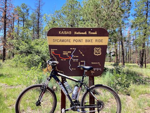
My plan today was to ride my mountain bike on Kaibab National Forest roads, about nine miles from White Horse Lake to Sycamore Point — where I intended to meet my wife and enjoy a romantic, scenic, picnic. Then ride back. As long as the roads were decent, I could do 20 miles.
Hoping to hit the trail by 9:30 a.m., my wife & I left Phoenix earlier than normal.
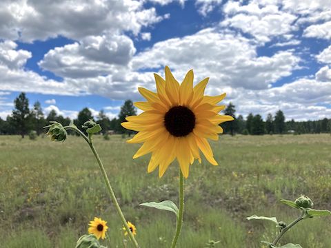
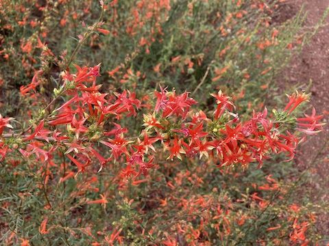
There were some roadside common sunflower (Helianthus annuus) along I-17, but on I-40 between Flagstaff and Williams they were everywhere. Hard to determine at 75 mph, there were even more tubular red flowers, which I later found to be skyrocket (Ipomopsis aggregata). I’ve never seen so many skyrocket! And in such dense clusters! 😳
Anyway … After various stops along the 3+ hour drive from Phoenix, I rolled out from White Horse Lake Campground 50 minutes late. From the free day-use parking at Black Bear Snack Shack, I followed a near-shore dirt path to the east end of the lake. I was expecting to ride between car-blocking boulders up on to FR 12 / Ruin Mountain Rd., but my way was barred by a barbed-wire fence and locked gate.
After heaving my bike over the White Horse Lake fence, I started riding down FR 12. Just past the east end of the fence is a pullout. I’d use that as a trailhead instead. Save yourself the heaving.
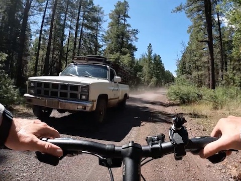
FR 12 / Ruin Mountain Rd. and FR 110 / Sycamore Point Rd. are wide enough for two vehicles — or a vehicle and a bicycle. On FR 12, I was passed by pickup truck that gave me a wide berth and overtook slow; an SUV that also gave space, but was moving fast; and a pickup that was too close for comfort. (Particularly with slushy berm gravel.) On FR 110, I was passed by a trio of ATVs, with no problems.
Note: From JD Dam Lake, FR 110 is also known as Sycamore Point Bike Trail #131.
Only critters I saw were a small herd of cattle, and one deer that crossed FR 12 barely in range of my GoPro. (Because I use the wide-angle setting, objects in the middle of the frame appear further away.)
Sulphur buckwheat (Eriogonum umbellatum) were fairly common along Sycamore Point Bike Trail #131, but otherwise flower coverage was sparse: I spotted spreading fleabane (Erigeron divergens), red & yellow pea (Acmispon wrightii), golden tickseed (Coreopsis tinctoria), velvety goldenrod (Solidago velutina), showy goldeneye (Heliomeris multiflora) and Wheeler’s thistle (Cirsium wheeleri).
I biked the four up & down miles of FR 12, non-stop, in only 33 minutes. Seemed longer. There were no big “climbs”. Even though I rode at a good pace, I could feel the 6,600 ft. elevation. (Exactly a mile higher than my house in Sunnyslope.)
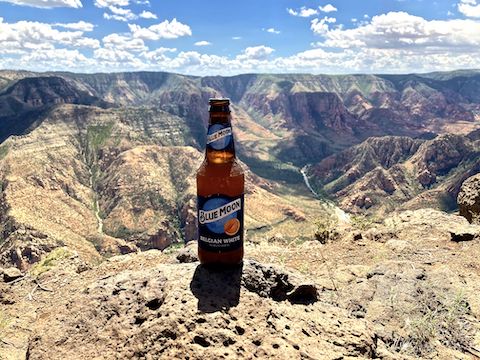
At the Sycamore Point Bike Trail #131 trailhead, I stopped, waiting for my wife, who arrived a few minutes later. I had made a strip map for her, but wanted to make sure she made the correct turn. Besides our picnic, meeting her at the scenic vista would allow me to top off my water. 💧
The GPS file attached below contains an alternate route to the Sycamore Point Bike Trail #131 trailhead. The alternate adds a 300 ft. climb from White Horse Lake to the saddle between Red Knoll and Hill One. (That’s its actual name.) The alternate is also all on Kaibab National Forest roads. There is no singletrack anywhere in the vicinity.
Sycamore Point Bike Trail #131 descends a fast 150 ft. in ¾ mile. Though the road is great for driving, I had to mind the gravel slush between tire tracks, lest I do another painful Bean Peaks. 🤕
Sycamore Point Bike Trail #131 levelled out for a ½ mile, made another short descent, then eased imperceptibly down the remaining miles to the scenic vista. Whereas FR 12 was in pine forest with pleasant spot shade, the last four miles on FR 110 crossed open grassland with scattered juniper.
Though a mile longer than FR 12, I completed Sycamore Point Bike Trail #131 quicker, in only 31 minutes. There are no facilities — not even a picnic table — overlooking Sycamore Canyon. I’m sure that’s why there’s no camping or fires allowed within a quarter mile. The views are incredible: Mingus Mountain and Woodchute Mountain were visible 23 miles southeast, across the Verde Valley.
My wife & I finished our picnic at 12:30. Riding back uphill to White Horse Lake would have taken longer, especially stopping for photos. I could have done it, but we probably wouldn’t have gotten home until 7:00 p.m. Instead, we drove back from Sycamore Point together. So, yeah, I basically drove seven hours for a one hour ride. 🤪
White Horse Lake Directions: From I-40, just east of Williams, take exit 167, south onto FR 146 / Garland Prairie Rd. Start your odometer. At 1.3 miles, after crossing the railroad tracks, the road splits at a Forest Service fire sign: Split left onto cinders. An info / map board is just ahead on the right. Stay on FR 146 / Garland Prairie Rd. At 3.8 miles there is a split; stay left. At 7.9 miles, turn right onto FR 109 / White Horse Lake Rd. At 12.9 miles, turn left into White Horse Lake Campground. Parking by the snack bar is free. Alternately, continue past the campground. At 13.5 miles, turn left on FR 12 / Ruin Mountain Rd. At 14.6 miles, just past the east end of the campground, there is a pullout. Park there.
GPS File: White_Horse_Lake_to_Sycamore_Point
Distance: 9.91 mi.
AEG: 228 ft.
Time: 1h 04m
Rumble Video
Vimeo Video
Biking White Horse Lake to Sycamore Point from Preston McMurry on Vimeo.