After missing the trailhead, doubled back and drove over a small ditch to park. Trail #289 does not follow the path indicated on FS Topo or MyTopo. It criss-crossed Pine Creek several times, and is up and down, though obviously tending up. There were motorcycle and animal tracks in the trail, all the way to the top, but no human or horse prints. I was surprised at the fall colors, including one flame red tree, whose leaves were obscured by numerous leaf-less branches. I still got a decent picture, I think.
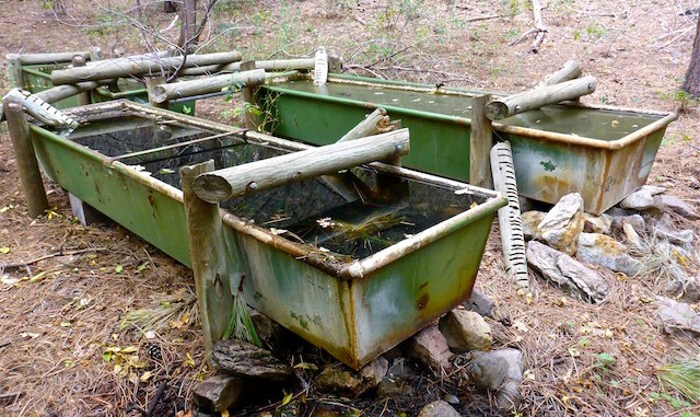
Spotted a triple-box tank just east of the trail. It had some interesting wood bits & bobs, the purpose of which escapes me. Just past that, the topos claim Trail #289 goes up Pine Creek. I saw no such thing. ![]() Instead, the trail turned the opposite direction, west, beginning a steep and gravel slippery climb to the rim. The entire trail below the Big Bug Mesa rim is riddled with gnats, and I swallowed one and snorted another.
Instead, the trail turned the opposite direction, west, beginning a steep and gravel slippery climb to the rim. The entire trail below the Big Bug Mesa rim is riddled with gnats, and I swallowed one and snorted another. ![]()
I checked out a small wall at the top of (actual) Trail #289, then followed a jeep trail — there are jillions up there — for awhile before heading off trail to Hill 7020. Just south of the hill, a foot trail headed left / west. I followed it for a bit, but it seemed to be heading down, perhaps towards Old Dandrea Ranch, so I skipped it.
Hill 7020 had awesome views of Moscow Peak, Mount Davis & Mount Union (each about two miles across Turkey Creek) and what sure looked like the San Francisco Peaks. I usually only slowly eat half my QT sandwich during a hike, but I wolfed down both halves. Whereas most of the hike was 1-bar reception, Hill 7020 was 4-bars, so I sent my wife a selfie to let her know I was okay. After Hill 7020, I spent some time searching for USMM 3. The ones I have seen before have a marking stake, then a rock with the number carved into it. I saw no stake, nor carved rock. (Just a beer bottle.) Bummer. ![]()
I followed a jeep trail towards the mesa’s east rim, which also had great views, then cut cross country to what I hoped would be a line shack. It was, but was useless. Just past that was a couple of acres strewn with debris and garbage, in the middle of which was a collapsed home. Judging by the remains, it had log beams, with asphalt-shingled roof, and possibly a partial second story. There was a curved cinder block wall/rotunda on one side. Maybe 2000 square feet. It was a shame what has happened to it, as it was obviously at one time a very nice place, not a crap shack. Now, it’s not useful for anything other than rats; you couldn’t even shelter in it from a storm. When I heard some guys approaching on ATVs, I departed. Thankfully, no shooting ensued.
After the ruins, I searched for a trail down Pine Creek. I found none, and side-sloping was actually more impractical than the creek bottom, so down I went. It was quite congested with rocks and dead fall, and even a barb wire fence (wth!?) and was very slow going. At one point, I went to steady my hand on a rock, and instead steadied my hand on the business end of an agave. Ouch. Finally I popped out at Seaton Spring, which was trickling and also had a full box. I was quite relieved. Never saw any trail up in Pine Creek. The maps lie. ![]()
While it had been cloudy most of the day — and I could see rain at several distant compass points — it was actually sunny for a bit on the way back down Trail #289. However, the crickets started chirping at 4:00 p.m. and the sun began disappearing quick. It was dusky — though not yet dark — by the time I hit the trailhead at 5:00 p.m.
—–
Two days later, and oddly the only sore part of my body is from my right elbow up to my shoulder. Wonder if I might have pulled something scrambling down to Seaton Spring … ![]()
GPS File: Pine_Creek_Trail_289
Distance: 12.43 mi.
AEG: 1,835 ft.
Time: 5h 42m
Hike Video
Pine Creek Trail #289, Big Bug Mesa from Preston McMurry on Vimeo.
