
")
Sunrise Peak is in Scottsdale’s McDowell Sonoran Preserve, the largest city park in the United States at 30,500 acres. Maricopa County’s McDowell Mountain Regional Park, adjacent to the east, effectively adds 21,000 acres to the “park”. Between them, the parks have ~230 miles of trails.
Sunrise Peak, which I last hiked with my company hiking club in 2008, has good bang for the short hike buck: 6.0 mi., 1428 ft. AEG, round trip. In my aging fat guy way, Sunrise Peak is part of me training to resume day hiking Appalachian Trail segments a couple of times a year.
Lost Dog Wash Trailhead has shade, his & hers flush toilets, human and canine water fountains, a mapboard, etc. It is open from sunrise to sunset. I started hiking at 7:40 a.m.
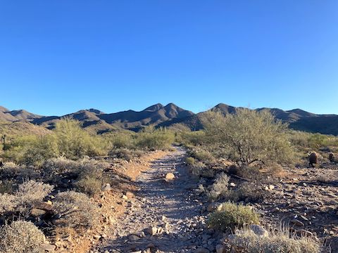
From the Lost Dog Wash Trailhead, head north, past the nature trail, for 300 yds., crossing the wash. There is a signed, but unnumbered, trail split. Go right on Sunrise Trail. In another 100 yds., at marker AS3, the trail splits again. Go left on Sunrise Trail.
It quickly became apparent that despite getting about ⅒” rain over the weekend — and the temperature quickly warming from 61℉ — there would be few, if any, desert flowers. 😕
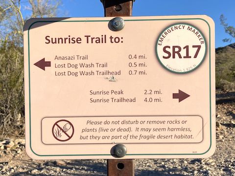
Every McDowell Sonoran Preserve trail intersection is signed with a two-letter trail abbreviation and a number. On Sunrise Trail (SR), the numbers count down as you near Sunrise Peak. Presumably, you’d give 9-1-1 the number, but I only had 0-1 bar Verizon reception even on Sunrise Peak’s summit.
Sunrise Trail’s 1.3 miles between SR17 and the saddle at SR15 pitches up to 9.7% slope. It’s a noticeable difference, but it was worse before they recently added switchbacks. Being on the south wall of the canyon, Sunrise Trail was still in full shade at 8:30 a.m. In the sun, there’d been no flowers to speak of. In the shade, I finally saw a blooming ocotillo. The canyon still had sport shade on my return at 10:30 a.m.
The 136th Street Spur intersects Sunrise Trail at SR15. Climbing Sunrise Peak via 136th Street Spur shaves 0.8 mi. off your round trip, but most of it splits mansions, and its trailhead has no amenities. The quarter mile of Sunrise Trail east of SR15 returns to a moderate 6.2% slope.
The next 300 yds. of Sunrise Trail has a healthy 20% slope. By comparison, Black Mountain is 21% for over a mile. So, Sunrise Trail isn’t bad. Then it’s a basically flat quarter mile to SR13.
Andrews-Kinsey Trail, around Adero Canyon, intersects Sunrise Trail at the SR13 saddle. Hiking Sunrise Peak from the Adero Canyon Trailhead is a half mile more and 150 ft. AEG less, round trip, than from Lost Dog Wash Trailhead.
That final climb is another 20%. But, again, it is short. Other than a strawberry hedgehog I found on my way back, the final part of Sunrise Trail had the best flowers of an overall poor display: brittlebush (Encelia farinosa), Emory’s rock daisy (Perityle emoryi), flat top buckwheat (Eriogonum fasciculatum), the unidentified yellow daisy, and some blue thing too small to photograph.
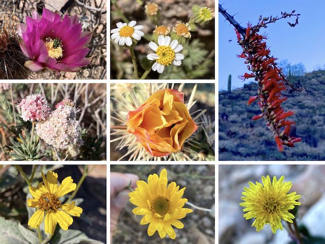
Top Row: strawberry hedgehog, Emory’s rock daisy, ocotillo.
Middle Row: flat top buckwheat, buckhorn cholla.
Bottom Row: brittlebush, unknown daisy, dandelion?
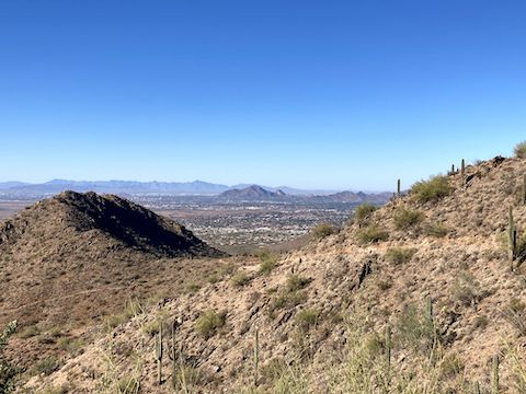
I spent 30 minutes lurking about Sunrise Peak’s summit. Not many people when I arrived: By 10:00, traffic was increasing. I took a few photos, but failed to take any of the 270° panoramic views: East End; the Mazatzal Mountains; Four Peaks; Stewart Mountain; the Superstition Mountains, including Weaver’s Needle and Flatiron; Arizona Dam Butte; Red Mountain; the San Tan Mountains; South Mountain; the Sierra Estrella; the Papago Buttes; Camelback Mountain; Piestewa Peak; and, just north, Thompson Peak. However, my hike video below does include a video panorama. 👍
Directions: From Loop 101 / Pima Freeway, take exit 41 east onto Shea Blvd. In 4.4 miles, turn left onto 124th St. Mind the two school zones, and the hard drainage dip at Via Linda. In 1.0 miles, drive straight into the Lost Dog Wash Trailhead. There is no entry fee.
Park Map: McDowell Sonoran Preserve trail map
GPS File: Lost_Dog_Wash_Sunrise_Trail_to_Sunrise_Peak
Distance: 6.25 mi.
AEG: 1,428 ft.
Time: 2h 34m
Rumble Video
Vimeo Video
Hiking Sunrise Peak, McDowell Sonoran Preserve from Preston McMurry on Vimeo.