
")
Cave Creek Trail #4, per the National Forest Service, “passes through the Arizona Upland Phase of the Sonoran Desert and through riparian areas of sycamore and cottonwood. Drier area vegetation includes saguaro, mesquite, palo verde and acacia. Eleventh-century Hohokam Indians farmed along the creek bed. Early cattlemen used the trail for moving livestock.” Modern ones too. 🤠
It’s been eight years since I’ve been out to Seven Springs, and fourteen years since I’ve hiked Cave Creek Trail #4 all the way to Spur Cross. The one thing I remember from 2017 is that the first week in April had great flowers: At least twenty different species, including dudleya, which I don’t find too often. On the other hand, 2025’s spring flower season has largely been a bust. Oh well, let’s give this a shot!
The Cave Creek Trailhead is in Seven Springs, 200 yds. north of the CCC Campground, on FR 24. I started hiking at 8:00 a.m., while my shuttle driving wife made the long trip back down FR 24 into the town of Cave Creek. (Lots of stuff named “Cave Creek” north of Phoenix.) You will also want to do Cave Creek Trail #4 as a shuttle hike, or key exchange, as the round trip would be 24 miles and 2,800 ft. AEG.
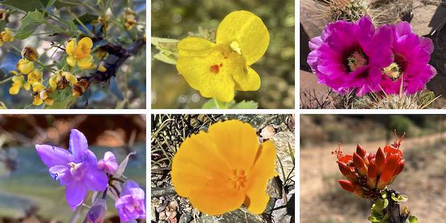
Top Row: red barberry, common yellow monkey-flower, strawberry hedgehog.
Bottom Row: blue dick , Mexican gold poppy, ocotillo.
Cave Creek Trail #4 starts by heading south, just above Maggie May Creek. After a fairly rocky 0.6 miles, the trail crosses FR 24B. I had considering driving down FR 24B, so I could start my hike at the old Ashdale Ranger Station, but FR 24B is gated. Facing a long, hot, day, I was already mindful of conserving energy. 😉
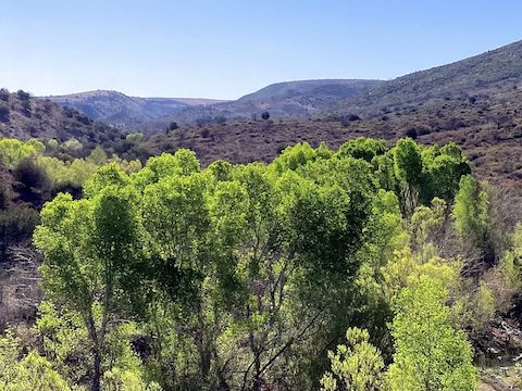
After the “stair gate”, the trail turns west, along the north side of Cave Creek, past Cartwright Ranch. Sometimes Cave Creek is underground, sometimes above, and occasionally audible. It’s a shady area. Pretty much the only one. Red barberry (Berberis haematocarpa) — shrub that looks like holly — was flowering. I also saw some small purple flowers not worth getting down for.
I’m pretty certain that Ashdale Ranger Station still existed back in 2011. Maybe not operational, but buildings sill erect. Now, it is just foundations and a stone wall or two. At 1.8 miles, Cave Creek Trail #4 passes through a v-gate and, a few hundred feet later, it crosses it’s namesake creek for the first time. (I lost count after the sixth creek crossing, but there were a lot more.)
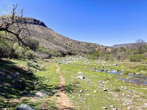
Cave Creek Trail #4 then drops back down to the second crossing. There were a number of common yellow monkey-flower (Erythranthe guttata) in the moist, grassy, area adjacent to the creek. I got my only wet foot at the second crossing. When water levels are higher, there’s good sitting pools there. The next mile of creek bottom is bouldery, so stick to the trail.
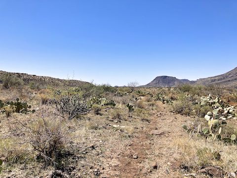
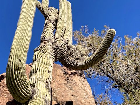
The next mile of Cave Creek Trail #4, now on the lower slope of Cramm Mountain, has an amazing quantity & quality of saguaro. At least two of them are crested. (Showing abnormal, swirling, broccoli-like growths.) I somehow missed A.B. Rock, which was engraved back in 1917. I did spot blooming strawberry hedgehog cactus (Echinocereus engelmannii), and blue dick (Dipterostemon capitatus).
After crossing water for the third time, I somehow wandered off Cave Creek Trail #4, following a use trail through the creek side grass. After five minutes, I realized I was fifty feet offline. I got back on trail, doubling back to the Skunk Trail #246 junction. That’s about where I bumped into a Cartwright Ranch hand, his pup, and string of horses. As he commented, nice day, but getting hot. 🌡
The fourth Cave Creek crossing is at 4.3 miles; the fifth at 4.8 miles. In that half mile section of Cave Creek Trail #4, I found a couple of Mexican gold poppy (Eschscholzia californica). After the fifth crossing, there is an old corral. A stone cabin is nearby, but no exploring: I was mission focused.
From the corral, the trail climbs 330 ft. to the base of Skull Mesa, which is the 6.0 mile point. It’s the only real climb on Cave Creek Trail #4, which actually drops a thousand feet between Seven Springs and Spur Cross. The last eight miles of the trail are exposed, and the temperature was already above the predicted high of 85°, and still rising. The fun part over, I began grinding.
“If something happens, or I burn out, does Cave Creek Trail #4 have any bail points?” No. You can always turn around, but if you are using a shuttle driver, where does that leave you? Stranded. (Though FR 24 does get a fair bit of traffic.) Also, there is no cell reception anywhere along this hike. You need to be self-sufficient, especially with water, and bring some sort of emergency beacon.
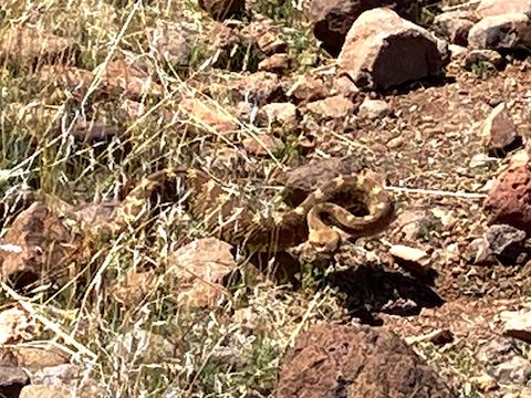
“What about snakes?” Glad you asked. I get rattled literally every time I am in this area. In fact, the first place I ever got rattled was on that Cave Creek Trail #4 hike fourteen years ago. Ironically, it was no more than a quarter mile away from where I got rattled today, near Chalk Canyon. 🐍
There’s some important things to remember about snakes: First, they are everywhere around you. You don’t notice them because they are well-camouflaged, and prefer shady spots under bushes and rocks, especially when it gets too hot. (Snakes like warmth, not heat.) You step next to snakes all the time: You just don’t know it because they don’t let you know.
When a snake rattles, it is being polite. (A rattle is not a threat.) The snake is saying “Hey! I’m over here! Please give me space.” And if you do, you will be okay. If you decide to be stupid, you will first get bit by the rattler, then by the hospital, for $10k+ per antivenin shot. And multiple shots may be required. So … leave the snakes alone, even the non-rattlers. Eventually they will slither off, allowing you to continue.
Still grinding, after 9.5 miles there is a sign for north-bound hikers announcing it is that distance back to the Cave Creek Trailhead in Seven Springs. Just after that, Cave Creek Trail #4 splits, around a small hill. Left is the more worn route; right the rougher official. I went right. The trails rejoin after a 180 ft. half mile drop to Cave Creek. Which the trail crosses. Again.
That Cave Creek crossing is marked on topo maps as “Spur Cross Trailhead”, and is the end of the official 10.1 mile distance. Which is nice — but you have two miles to go before you reach the nearest parking lot. At least those miles are creekside, and semi lush. Wearing a doo rag to screen the now 93° sun, I dipped it for some extra relief. 🥵
I finally dragged into the parking area at 2:30 p.m. I was spent. So it was off to The Grotto Cafe, in the town of Cave Creek, for delicious bacon grilled cheese, southwestern soup and, of course, restorative post-hiking beers!
Seven Springs Trailhead: From Loop 101 / Pima Freeway, take exit 36 north onto Pima Rd. Head north for 12.1 miles. Turn right on Cave Creek Rd. Pass by Bartlett Dam Rd., after which the road becomes very twisty. Mind your speed. Also, note the green MCDOT mileage markers. Continue past Bronco Trailhead (MCDOT 8). You will cross Cave Creek itself (MCDOT 12). FR 24B is on the left in 300 yds. It is another 500 yds. to the CCC Campground. In 200 yds., just after crossing Walnut Spring, Cave Creek Trailhead is on the left.
Spur Cross Trailhead: Drive back into Carefree. In 16.5 miles, at Pima Rd. go straight (not left), continuing west on Cave Creek Rd. In another 3.7 miles, in downtown Cave Creek, turn right at the Circle K, onto Basin Rd. Just after Basin Rd. bends left, turn right onto Spur Cross Rd. Stay on it 4 miles to the Spur Cross Trailhead. There is no fee to park, but there is a $3 envelope fee to hike / bike / horse ride into the conservation area.
GPS File: Cave_Creek_Trail_4
Distance: 13.05 mi.
AEG: 1,003 ft.
Time: 5h 30m
Rumble Video
Vimeo Video
Hiking Cave Creek Trail #4: Seven Springs to Spur Cross from Preston McMurry on Vimeo.