

This weekend was the third reunion of my old Army outfit, TACCP, Alpha Company, 50th Signal Battalion, 35th Signal Brigade … AIRBORNE! The first reunion was c. 2012. The second TACCP reunion, in 2017, had eighteen folks show up. This reunion was expanded to all 50th Signal Bn. veterans, regardless of era, and I’m guessing we had 80 veterans in attendance. More on that later. 🫡
Carvers Creek State Park is a 4,530 acre North Carolina reserve established in 2013. There are two units: Long Valley Farm, in Spring Lake, and Sandhills Access, five miles away near Fayetteville. Current, and former, parts of Fort Bragg separate the two units. Some of that land may eventually connect the two units.
Long Valley Farm features Rockefeller House and Mill Pond, which are on the National Register of Historic Places. Fishing is allowed in the pond. No swimming or boating. There are two trails: Rockefeller Loop Trail (2.1 mi.) and Cypress Point Loop Trail (0.4 mi.).
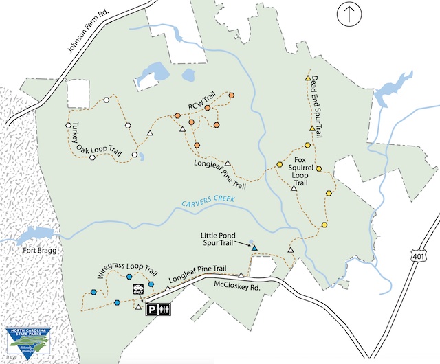
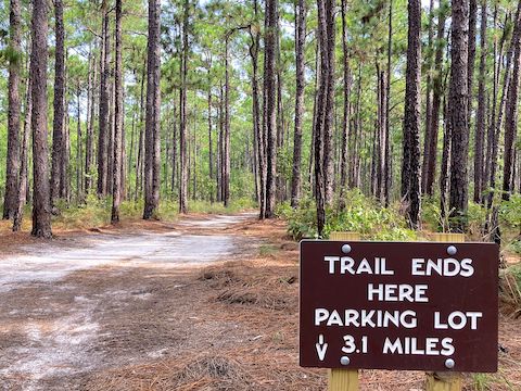
Sandhills Access trailhead has room for horse trailers. Fishing is allowed. Rest benches and picnic tables are scattered along the trails. Junctions are signed with direction & distance. Sandhills Access has no history, per se, but more trails to explore:
- Wire Grass Loop: 1.4 mi., blazed by blue hexagon. Accessible from trailhead.
- Longleaf Pine Trail: 4.0 mi., blazed by white triangle. Accessible from trailhead. Provides access to the following trails:
- Little Pond Spur: 0.1 mi., blazed by blue triangle.
- Fox Squirrel Loop: 1.1 mi., blazed by yellow hexagon.
- Dead End Spur: 0.6 mi., blazed by yellow triangle.
- RCW Loop: 1.5 mi., blazed by orange hexagon.
- Turkey Oak Loop: 1.7 mi., blazed by white hexagon.
Culvers Creek, itself, originates near the junction of McArthur Road and Johnson Farm Road, on the old Fort Bragg maneuver area. Culvers Creek then flows east through Sandhills Access; turns southeast, crossing US-401 near the Goodyear Tire & Rubber Plant; before emptying into the Cape Fear River after seven miles.
Because the reunion activities began mid-afternoon, my plan was to hike most of Longleaf Pine Trail (LLP), plus all of Fox Squirrel Loop Trail (FSL) and Dead End Spur Trail (DES). About 6.5 total miles, or roughly a 10k ruck run. Also, Little Pond Spur Trail. Hopefully that tenth of a mile — 2/10 round trip! — wouldn’t kill me. 😆
After first driving by McCloskey Road, my wife & I arrived at the Sandhills Access trailhead at 8:30 a.m. The trailhead has a wood hitching post, and plenty of room for horse trailers. There’s two map & info boards, one across McCloskey Road with nature brochures, and one at the west end of the lot, without. There are clean his & her pit toilets, with dispensers that actually contain hand cleanser! Whoa.
At every trail junction, there are signs with trail names, direction, distances and blazes. Beside the trails, there are additional blazes nailed into the eponymous longleaf pine. Some of the blazes have the trail abbreviation and distance magic-markered on them. Longleaf Pine Trail also has mileage posts every half mile. The post & blaze distances are accurate. Ignore the white plastic ground arrows.
I hiked out the west end of Sandhills Access, by the two picnic tables. Longleaf Pine Trail curls around the paved end of McCloskey Road to the brochure rack. Cutting across the road would only save you a quarter mile. Though I picked up a flower brochure, I did not spot any of the flowers in it. 🤷🏻♂️
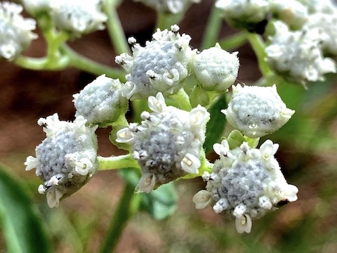
I don’t know about the rest of the year, but in mid-September Carvers Creek State Park did not have many flowers. Still, there were more than the zero I saw in Raven Rock State Park in June. Besides the flowers pictured above & below, I also found Maryland meadowbeauty and white coral vine.
Top Row: Atlantic goldenrod, blazing star, kidneyleaf rosinweed.
Middle Row: narrowleaf ironweed, hyssopleaf thoroughwort, coral vine.
Bottom Row: purpledisk sunflower, bigroot morning glory, narrowleaf silkgrass.
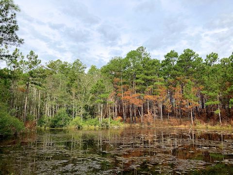
Longleaf Pine Trail closely parallels McCloskey Rd., through an old prescribed burn area. After a mile, LLP makes a 90° left, dropping 50 ft. over several small whoops to the Little Pond Spur Trail junction. It would be fun to ride that on a mountain bike. Down. Up would suck throughout Sandhills Access due to, well, the sand. (Not nearly as much sand as Split Oak Forest, but just enough for uphill wheel spin.)
After checking out Little Pond, I continued on Longleaf Pine Trail. Carvers Creek runs through a conduit, so the crossing is dry. At the two mile post, Longleaf Pine Trail bends left. Instead, I split right onto Fox Squirrel Loop Trail, which had a slightly firmer surface. Nothing really interesting on FSL, but it was a pleasant stroll. At the FSL 0.8 blaze, I split right onto Dead End Spur Trail. DES was pleasantly similar.
I was tempted to see where Dead End Spur Trail actually ends — probably Firethorn Dr. in 250 yds. — but instead doubled back to Fox Squirrel Loop. From DES, FSL makes a speedy 50 ft. mountain bike drop in one third mile — where it connects back to LLP. Longleaf Pine Trail parallels Carvers Creek, which is ~100 yds. away, and crosses several tributary trickles, so LLP was the moistest part of my loop.
Back at the LLP 2.0 post after five miles, and many pictures, I picked up my pace, making it back to the Sandhills Access trailhead in only 37 minutes. My 3.13 mph average moving speed attesting to the ease of hiking Carvers Creek State Park. All morning, I only saw one dog walker, and one family, so I can only assume that the locals are doing more serious hikes in Fort Bragg’s maneuver area. 🪂
Directions: From Interstate 295, take exit 28 north, onto Ramsey St. / US-401. In 0.6 miles, at the South River Electric facility, turn left onto McCloskey Rd. The Sandhills Access trailhead is in 1.9 miles, at the end of McCloskey Rd.
GPS File: Carvers_Creek_State_Park_Sand_Hills_Access
Distance: 7.31 mi.
AEG: 256 ft.
Time: 2h 20m
Rumble Video
Vimeo Video
Hiking Carvers Creek State Park from Preston McMurry on Vimeo.