

The Butterfield Stage was only in operation from 1858-1861, but the Southern Emigrant Trail across the desert Southwest was in use from Juan Bautista de Anza (1774) until the Southern Pacific Railroad connected Arizona to the rail network in 1880. The Oatman Family was massacred on the trail in 1851.
Much of the Butterfield Stage Trail has been erased by cities, highways, farms, etc. But parts remain, including at least 29 miles in Maricopa County. I’ve divided those miles into four segments, each of which is anchored at both ends by AZ-238. A month ago, I biked Enid to Christmas Camp. Today, I biked from Christmas Camp to the de Anza wilderness registry at the bottom of Butterfield Pass.
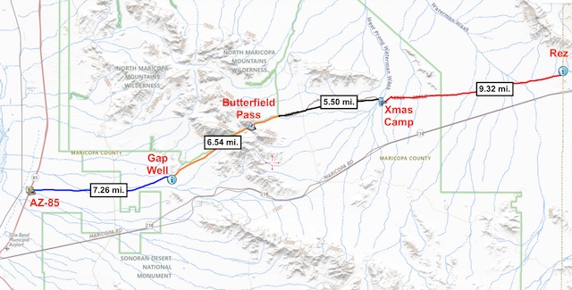
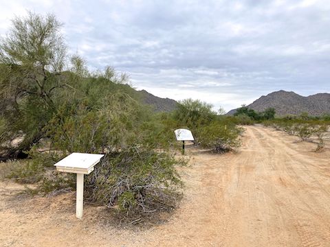
Eleven years ago, when I hiked through Butterfield Pass, the Bureau of Land Management (BLM) did not allow any motorized traffic in the Sonoran Desert National Monument. So, my shuttle-driving wife had to park on the AZ-238 shoulder. Today, the barbed wire gate could be opened, and there were no “Closed Area” signs. There was actually an info board. (See the video thumbnail, below.)
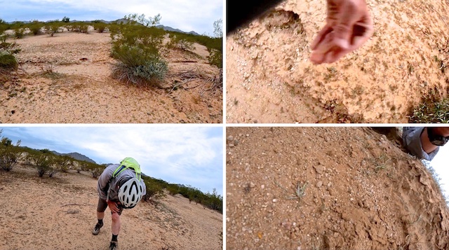
I saddled up at 9:17 a.m. Though 10° warmer than a month ago, it was totally overcast, so it felt cooler. Initially, the sand on BLM 8003 was not too deep, but I was working too hard. Instead, I rode most of the way to North Tank on the east side of BLM 8003. Where the sand gets quite deep. The rest of the day, I biked road / trail where I could, went cross-country when I couldn’t, or pushed when I had to.
2.3 mi.: The first Mormon Battalion skull pole is 150 yds. past the North Tank corral. By some descriptions, that skull pole is mile marker 0, for miles west of Christmas Camp. (Where the Mormon Battalion spent Christmas, 1846.) I use mile marker distances in my video; in this blog, the bold distances are how far into this ride I am. Hopefully, that isn’t too confusing. The Butterfield Stage later built its Desert Station on this site. Apparently, there is a history sign across BLM 8003, but I missed it.
After crossing the deep sand of West Prong Waterman Wash, there is a kiosk with no info at all. BLM 8003 continues right to Conley Tank, while the Butterfield Stage Trail veers left across a small wash, where there’s another skull pole. It’s not obvious, but trust me: That’s the historic route, as per topo maps. Since the roads are often squishy, I followed the historic route. Both BLM 8003 and the historic route are the same distance to MM 4.
3.3 mi: Mile marker 1.0 skull pole. There is enough shrubbery on the Butterfield Stage Trail that you can’t see from one marker to the next. After 35+ years, the markers’ weather aged structures blend with the Sonoran Desert’s natural colors. Generally speaking, if you aim at Butterfield Pass — the prominent notch in the Maricopa Mountains — you will be on track.
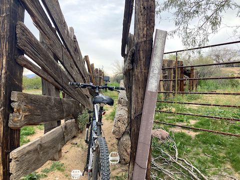
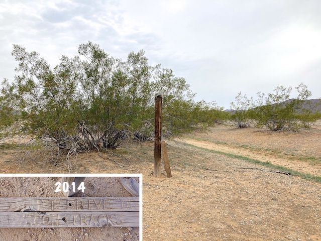
3.8 mi.: Mile marker 1.5 fiberglass post. It’s there for a reason. What that reason is, I don’ know. There is no sticker on it, like the post back at the North Tank corral. In 150 yds., on the other side of the small wash, are the remains of the “Don’t drive on wagon tracks” sign.
4.2 mi: Mile marker 2.0 has a skull pole and a wood post with “1846 – 1848” carved in its worn surface. From what I’ve been able to gather, the older wooden markers were placed by the Kimball Stake, while the skull poles mostly seem to have been placed by the East Stake’s Bryan Jarman as a 1987 Eagle Scout project. Boy Scout Troop 507 placed an additional plate under one skull pole in 2002.
A half mile later, I got off track on north side of densely vegetated wash. No way you could ride that. I struggled to push my MTB through it.
5.2 mi.: I saw neither skull pole, nor wood post, where mile marker 3.0 should be. Supposedly, the skull posts are about a mile apart, but as we saw with the first two, that is not always true.
5.8 mi: Mile marker 3.6 skull pole, 1.6 miles after the previous one. And …
6.2 mi.: Mile marker 4.0 skull pole at Butterfield Stage Trail’s intersection with BLM 8003. (If you instead split right at the empty kiosk, this is where you would end up.) The intersection is marked by a prominent saguaro. 🌵
6.6 mi.: Boy Scout Troop 554 wood post marked “1846 – 1848”. It doesn’t look like there was any coordination between the various Boy Scout troops marking the Mormon Battalion Trail in the pre-internet age.
7.2 mi.: I mixed riding trail, with riding dirt roads, with riding cross-country. Whatever was easiest, while basically staying on track. Riding a bit off trail is how I found this stub of an old wood post. Presumably, it was once planted by a Boy Scout, as there are no nearby corrals.
7.7 mi.: The de Anza registry at the Butterfield Stage Trail’s intersection with BLM 8002. BLM 8002 looks like it extends eight miles north to the pipeline road, which forms the north boundary of the Sonoran Desert National Monument. Butterfield Stage Trail continues west. Instead, I turned south on BLM 8002, which is smooth dirt, crossing many small washes.
9.5 mi.: I was passed by a Subaru. I thought the Sonoran Desert National Monument was still a “no vehicles” zone. Just after the Subaru, by the intersection with BLM 8002B, BLM 8002 turned to groomed gravel. Hmmm … Then, I was passed by a truck camper. I saw another truck camper, and a Class B, parked beside BLM 8002. Finally putting the clues together, I realized the rules must have changed.
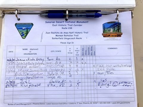
11.9 mi.: Named for the railroad siding across AZ-238, Estrella Road Trailhead is a gravel lot, large enough for horse trailers. It has a trail registry, info board, maps you can take with you, three cement picnic tables, two grills, and a fire pit — but no pit toilet. Still, can’t complain, as it is now open.
Estrella Siding was established in 1881. By 1922, Estrella Hill — or just Estrella — had a post office, boarding house, general store, and service station. By 1961, the small town had vanished. If you look at modern satellite view, not even any foundations remain.
BLM 8003 Directions: From Phoenix, head south on I-10. Take exit 164 onto AZ-347. In 14.7 miles, just after entering Maricopa, turn right on AZ-238. Just past milepost 26, turn right on BLM 8003. Park by the wilderness sign.
Estrella Road Directions: Continuing on AZ-238, just east of milepost 21, turn right on BLM 8002 / Estrella Rd. Park in the gravel lot.
GPS File: Butterfield_Stage_Xmas_Camp_to_de_Anza_Registry
Distance: 13.44 mi.
AEG: 330 ft.
Time: 2h 40m
Rumble Video
Vimeo Video
Butterfield Stage Trail: Xmas Camp to de Anza Registry from Preston McMurry on Vimeo.