I started hiking at 0820. It was sunny, high 50s (warming to upper 60s), no breeze. I liked the Seven Springs area so much last week, that I decided to return this week. Last week it was the Cave Creek Trail #4 and Skunk Tank Trail #246 loop; this week a one-way from Bronco Trail #245, some exploring up Bronco Creek, then Cottonwood Trail #247 up to the Cave Creek trailhead. Trail #245 starts with a short climb that is the steepest I’ve so far been on, about a 100 meter rise in 500, continuing a slow climb after that. You can actually see Weaver’s Needle, 43 miles distant, from the ride.

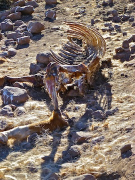
The first 2 km are old jeep trail, narrowing to single track as you skirt the northern edge of the first hill. There’s some parts where the grass has overgrown the trail, but it is still easy to follow. There is another 100 meter climb up to the Hill 4437 saddle before descending to the East Fork tank. There are some pretty berries in the saddle. The tank was bone dry, and there was a seriously dead horse there. And lots bird poo — which probably used to be horse. ![]()
At the first T-intersection, where the description says stay right, I purposefully veered left down the wash. I reached this point in 64 minutes, or roughly 70% of the low end of the recommended 3-4 hrs. round trip time for Trail #245. There are three roughly parallel creeks here, of which Bronco Creek is the middle and longest. I meant to go up Bronco Creek, but actually got onto the unnamed creek just east of it. I used a cattle trail to cut the small hill back to Bronco Creek. I intended to go all the way past Jack Springs, to the source of Bronco Creek, cut the saddle north to the other small creek, then take that back to the t-intersection. But I got stopped by a barb wire fence about 1.5 km up. The fence runs at an azimuth of roughly 120 degrees on a line that would take it from Head of Cottonwood Spring to Blackberry Spring. Not wishing to intrude, nor go back the way I came, I followed the fence’s back azimuth towards Head of Cottonwood Spring. Lots of prickly bushes, and three short but very steep arroyo climbs. Eventually, near Head of Cottonwood Spring, with what I thought was Trail #247 in sight, the fence made a sharp turn right, across my line of travel. ![]() Not wishing to battle any more prickly bushes, nor travel further than necessary — my wife was expecting me in about an hour up at the Trail #4 trailhead — I threw my pack over the fence, then crawled under it. I found the trail, and followed it down a ridge, which I believe was the ridge immediately northeast of Head of Cottonwood Spring. It may have been Trail #247, but I don’t think so, as at the bottom of the ridge it intesected with all the other trails in that area (#247 west, #247 north, #245, etc.).
Not wishing to battle any more prickly bushes, nor travel further than necessary — my wife was expecting me in about an hour up at the Trail #4 trailhead — I threw my pack over the fence, then crawled under it. I found the trail, and followed it down a ridge, which I believe was the ridge immediately northeast of Head of Cottonwood Spring. It may have been Trail #247, but I don’t think so, as at the bottom of the ridge it intesected with all the other trails in that area (#247 west, #247 north, #245, etc.).

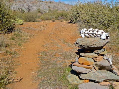
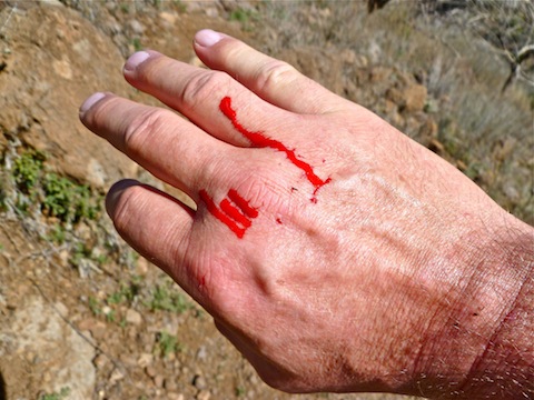
Then I started up Trail #247 North. Or, as I call it, the “Critter Crapper Trail”, or “Cairn Trail”. (Seriously, I counted 33 cairns on the easy to follow trail. ![]() ) Trail #247 North is up and down, and winds back and forth across the creek. By the way, every “body of water” I encountered prior to Cave Creek itself, was bone dry. Cairn #7 was kind of amusing, as someone had decorated it with a small animal skeleton. There was lots of scat on the trail, including at least one black bear, about 3-4 miles southeast of where I found black bear scat on Trail #4 last week. I caught my hand on a wait-a-minute, causing it to drip blood.
) Trail #247 North is up and down, and winds back and forth across the creek. By the way, every “body of water” I encountered prior to Cave Creek itself, was bone dry. Cairn #7 was kind of amusing, as someone had decorated it with a small animal skeleton. There was lots of scat on the trail, including at least one black bear, about 3-4 miles southeast of where I found black bear scat on Trail #4 last week. I caught my hand on a wait-a-minute, causing it to drip blood. ![]() Cave Creek looks down a little bit since last week, so I was able to find a dry way across. The first humans I encountered the whole day were six on horseback just before the Seven Springs TH.
Cave Creek looks down a little bit since last week, so I was able to find a dry way across. The first humans I encountered the whole day were six on horseback just before the Seven Springs TH.
p.s The rednecks were out of hibernation: As we drove back south on FR 24, we almost got clobbered by a couple of yahoos on ATVs.
Distance: 8.90 mi.
AEG: 1,500 ft.
Time: 3h 19m

