
")
The Great Allegheny Passage, aka the GAP Trail, is a 150-mile rail trail that travels from the end of the C&O Canal in Cumberland, Maryland, to Point State Park, at Three Rivers in Pittsburgh, Pennsylvania. Both Allegany and Allegheny are correct spellings: Allegany is a county in western Maryland, while Allegheny is a mountain range and river in Pennsylvania.
Today, I biked the GAP Trail from Cumberland to Frostburg. It’s 15.5 miles, one way, gaining 1,200 ft. (A steady, but negligible, 1.5% grade.) Since the return trip is obviously downhill, I decided to do a 32-mile out & back ride. Barring some GoPro battery issues, I rode non-stop uphill, filming with my GoPro. On the return, I stopped for photos.
MP 0.0: Leaving Canal Place, head north along the grey bricks towards the traffic circle, past the warehouse, to the green bike lane crossing at Baltimore St. After that, the GAP Trail is obvious. The only time I got confused is at the alternate trailhead, off Lee St. I split right, across the lot. Then turned around, and went left instead. Either way works, as they connect back up north of the Valley St. bridge.
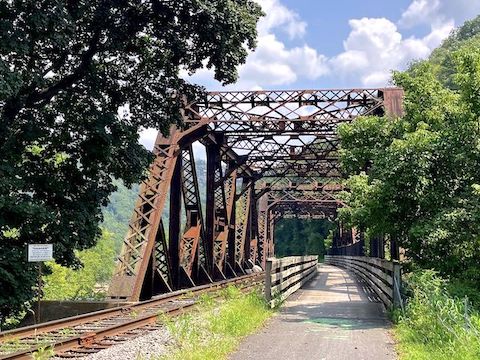
MP 1.3: The GAP Trail enters mile long Cumberland Narrows, a 900 ft. deep natural cut that splits Haystack Mountain (above the trail) from Wills Mountain, on the opposite side of Wills Creek’s concrete channel. MD-36 also squeezes through The Narrows. One of Wills Mountain’s cliffs is, of course, named Lovers Leap. Exiting Cumberland Narrows, the GAP Trail crosses the steel truss bridge over US-40.
MP 3.9: The Cumberland Bone Cave is on the left side of the GAP Trail. The Bone Cave contains 41 genera of mammals; 16% of which are extinct, including saber-toothed tiger and short-faced bear. There’s gaps in the chain link fence, but no sense in cheating as the cave is filled with rockfall. 😕
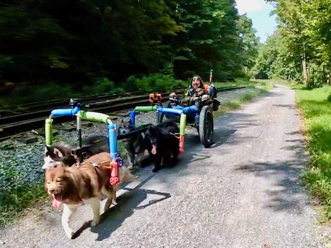
MP 5.3: Helmstetter’s Curve is the first ~180° turn on the Western Maryland Scenic Railroad (WSMR). Approaching Helmstetter’s Curve, I saw what I first thought were Old West-type railroad handcars, of the type you used to see in black & white cowboy movies. Actually, they are foot-powered “rail bikes”, that folks rent from Tracks and Yaks in Frostburg. I counted a dozen over the next couple of miles.

Top Row: Queen Anne’s lace, birdfoot trefoil, wild bergamot.
Middle Row: asiatic dayflower, browneyed susan, chicory.
Bottom Row: eastern daisy fleabane.
MP 6.4: Brush Tunnel is a 914 ft. passage under a Piney Mountain spur. Brush Tunnel is lighted, but it’s darker than it appears in the header photo, above. I added front & rear white & red blinkers to my WheelzUp rental bike just in case. The rental had 24 gears: I rode to Frostburg in 11th or 12th gear, and back down to Cumberland in 14th or 15th gear. Easy spinning wheels and grippy brakes. 👍
MP 9.6: Located between Pine Mountain and Federal Hill, Woodcock Hollow is the GAP Trail’s second ~180° curve. But unlike Helmstetter’s Curve, Woodcock Hollow has no sweeping views as it is buried in the forest. Good riding shade is a positive, especially on days that are sunnier than expected. (A week ago, 50% rain was predicted.)
MP 14.3: The WMSR tracks split left. In the next mile, the railroad tracks twice curl over the GAP Trail. I still hadn’t seen the train, heading either way. I had one more opportunity, at the turntable in Frostburg.
Like the C&O Canal, nature & history signs dot the GAP Trail. Memorial benches as well. Plus odds & ends like abandoned rail cars. The trailheads at Helmstetter’s Curve and Woodcock Hollow both have portapotties. Human traffic was not heavy, but steady with walkers, joggers, day riders and bike tourers.
MP 15.5: The Frostburg Trailhead is downhill from the town itself. There’s a cabana, picnic table, and portapotty. You can ride up steep New Hope Rd., but I chose the switchbacked trail. I didn’t get far before before I had to hike-a-bike. Might have made it, but for the squishy sand. The advantage of taking the switchbacks is displays of public art and a coal miners’ memorial.
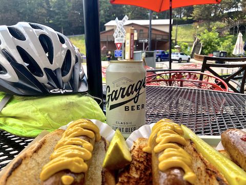
Though I did not need a shuttle driver, my wife met me in Frostburg for lunch. There’s three drives from Cumberland to Frostburg: I-68, US-40 and MD-36. She took MD-36, as it is more scenic, along the Jennings Run river valley. After lunch, I headed back to Cumberland, finishing just after 2 p.m. It was such a relaxing ride, I’ve already begun planning how to bike the rest of the Great Allegheny Passage!
Cumberland Directions: From I-68, take exit 43C to Downtown Cumberland. At the bottom of the ramp, turn left on Harrison St. At the next intersection, Canal Place (MP 0.0) is across the street.
Frostburg Directions: Head back east on Harrison St. Follow the I-68 Frostburg sign back on to I-68 west. In 8.6 miles, take exit 34 onto MD-36 north. In 1.3 miles, turn left on National Pike. In 0.8 miles, turn right on Depot Terrace. In 0.2 miles turn left on Depot Street. Take the next right on New Hope Rd. In 250 yds., the trailhead is on the right.
GPS File: GAP_MP0to15_Cumberland_to_Frostburg
Distance: 32.31 mi.
AEG: 1,328 ft.
Time: 3h 12m
Rumble Video
Vimeo Video
GAP Trail: Biking Cumberland to Frostburg, Maryland from Preston McMurry on Vimeo.