

Maverick Hill is a straight forward workout hike, in a remote location, with some good views.
But Maverick Hill is a long way from Phoenix. At least four hours, one way, depending on traffic. So, my wife & I drove up the day before, and drove home the day after. (Which also gave us the opportunity to hit up the always delicious Taylor Freeze in Pima.) Did you know tiny Pima, then less than 900 souls, lost 27 of its sons — America’s highest casualty rate — in World War II? 🙏🏻
It’s also a fair distance from Thatcher to Black Jack Campground, 51 miles, taking an hour to drive. Black Jack Campground has twelve spots, each with picnic table, fire pit and grill. There are two pit toilets, each a double: A coed in the middle of the campground, and a his & hers the south end, next to the group camp. That’s where we parked, away from prying eyes of other folks (and passing traffic).
However, the Maverick Hill hike starts at the north end of Black Jack Campground, which is why my stats are greater than the hike’s normal 7.0 miles, 1,500 AEG (accumulated elevation gain), round trip. A flat extra mile on a short hike is no big deal. Plus, it gave me a chance to loosen up my legs. 🚶🏻♂️
Officially, the hike starts opposite Black Jack Campground’s entrance: Pass through an unsigned gap in the fence, onto Black Jack Trail #568. (I missed the gap on my way out, but hit it on my way back.) The road is smooth, and easily car drivable for ⅓ mile, if you want to shave off a little more distance. On the left is a dry cattle tank, incongruously featuring a barrel-mounted swim raft.
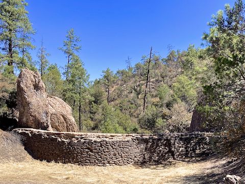
After ⅓ mile, Black Jack Trail #568 makes a rocky descent to White Mule Creek. Philips Tank — also dry — and its beautiful arched stone dam is to the left. The trail turns south, again on smooth dirt, along the bottom of White Mule Creek. 200 yds. south of the dam, I accidentally split left, heading up a very rocky jeep trail. Back along White Mule Creek, the smooth jeep trail continues south to the 1-mile mark.
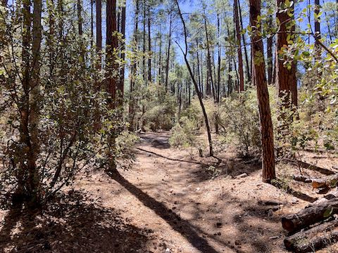
At an old fire ring, Black Jack Trail #568 turns left and starts climbing. The trail climbs 500 ft. (9.5% grade) in its second mile, 433 ft. (8.2%) in its third, and 334 ft. (12.7%) in its final half mile. It’s quite rocky at first, but not of the ankle-breaker variety. Rough driving on an ATV.
The Arizona white oak and ponderosa pine of Black Jack Trail #568’s first mile change to beehive cactus, Chihuahua pine, Gambel Oak, manzanita, mountain mahogany, Parry’s agave, silverleaf oak, twoneedle pinyon, and cane cholla. The cane cholla had fat yellow buds. The green flowered hedgehog were not actually flowering. I did not see any flowers — fleabane and verbena — until Maverick Hill’s summit.
The jeep trail gradually peters out, before ending at 2½ miles. Black Jack Trail #568 continues as usually well-defined foot trail 20 ft. on the other side of some small boulders. There are regular cairns. At the 3¼ mile mark, the trail does tight left-right switchbacks, marked by a sign announcing “Welcome to Strayhorse”. Not sure what that is about: google was no help. 🤷🏻♂️
I lost Black Jack Trail #568 after the Strayhorse sign, so I just followed the grassy spur I was on, up the final quarter mile to Maverick Hill’s ponderosa pine and alligator juniper shaded summit. Several cane cholla protect the summit cairn. The summit log was obvious. Opening the old jar was difficult, necessitating the use of three of my Leatherman’s tools. Took me 30 minutes. 😅
Not many entries in Maverick Hill’s summit log, but it should come as no surprise the oldest is Bob Moore. (A common name in Arizona summit logs.) I hope I live into my 80s, let alone keep hiking like Bob did. Despite its remoteness, I had 2-3 bar Verizon on the summit, so I texted my wife and was even able to post Maverick Hill photos on twitter. Break over, I headed back down.
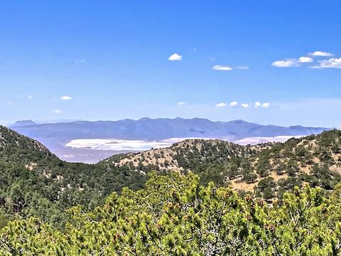
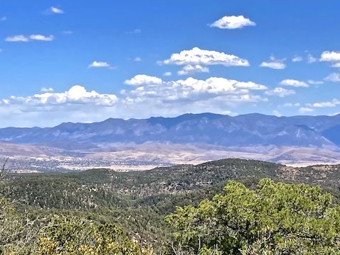
I really enjoyed the Maverick Hill hike: ★★★★✩. I would have rated it higher, if I hadn’t been expecting 360° summit views. Still the summit was beautiful & peaceful. One final note about my hiking video (below): It is only by sheer coincidence that my lunch had the same name as the hike. Small world. 😆
Black Jack Campground Directions: From Safford, head southeast on US-70. In ~10 miles, turn left on US-191. 23.6 miles, after crossing the Gila River, is the junction known as Three Way, marked by an old drive-in movie screen. Continue straight through the traffic circle onto AZ-78. The first couple miles of AZ-78 are relatively straight, but then it gets very twisty as it climbs Black Jack Canyon. Mind your speed. In 14 miles. just after entering the tree line, turn right into Black Jack Campground. Parking and camping are both free.
GPS File: Maverick_Hill
Distance: 8.86 mi.
AEG: 1,727 ft.
Time: 3h 43m
Rumble Video
Vimeo Video
Hiking Maverick Hill Trail #568, Arizona from Preston McMurry on Vimeo.