

This week, big chunks of the Coconino National Forest, Kaibab National Forest, Tonto National Forest, Apache-Sitgreaves National Forest, and Arizona state lands between the Grand Canyon and Mogollon Rim were completely closed due to Stage III fire restrictions. No one is allowed in, not even Forest Service officials.
That means almost everything above 6,000 ft. within a two hour drive of my home in Phoenix, across from North Mountain, is closed. In other words, almost everywhere I could go for a hike that would be less than 100°. 😕
When the closures were announced, I checked Prescott National Forest, and it was still open. There are parts that are above 6,000 ft., for instance Mount Davis & Mount Union. But I’ve done those before.
So, I started poking around Mingus Mountain — between Prescott and Jerome — on the topo. This is what I came up with.
I parked at the lower Woodchute Trailhead as it has a pit toilet, and my wife was along with me. But cars could easily drive 0.7 miles to the upper trailhead at the Woodchute Mountain Wilderness gate & info kiosk. Plus, there is more shade there. Doing this loop from the lower trailhead is 8.74 miles and 1,382 AEG; from the upper trailhead, you save 1.4 miles and 100 AEG. Not much. Hike from the lower trailhead. 💪
The Woodchute Mountain-Martin Canyon Loop does not actually summit Woodchute Mountain. As an option, summiting Woodchute Mountain would add a relatively mild 2.4 miles and 620 AEG to the loop. Doing Woodchute Mountain summit as an out & back, would be 7.8 miles and 1150 AEG. Doing Martin Canyon as an out & back would be 9.2 miles and 1200 AEG. (If you went no further down Martin Canyon than the Woodchute Mountain connector.)
For those looking for a short, mild, hike with plenty of #flowerporn, and awesome Verde Valley views, hiking from the upper trailhead to the Woodchute Wildernesss sign, then back, would be only 3.7 miles and 460 AEG, round trip — or less than Phoenix’s Shaw Butte.
Accumulated elevation gain (AEG) is the same whether you hike the Woodchute Mountain-Martin Canyon Loop clockwise or counterclockwise. I recommend hiking counterclockwise, as descending to Martin Canyon presents a beautiful vista that would otherwise be to your back.
It was a pleasant 62° when I hit the trail. There were a number of RVs camping along FR 102. Powerline Tank had water, but barely. I’d beg water from an RV before filtering from Powerline Tank.
But I carry plenty of fluids: My typical load is two 500ml G2 Gatorades, five 500ml bottled water and a 12 oz. beer. (Carbs are important. 😁) That’s 130 oz. of liquid. During my hike, I drank only three waters and a G2, even though it was 82° when I finished hiking at 1:40 p.m. I drink slow & steady, trying to keep my body fluid-balanced, rather than parched, then soaked.
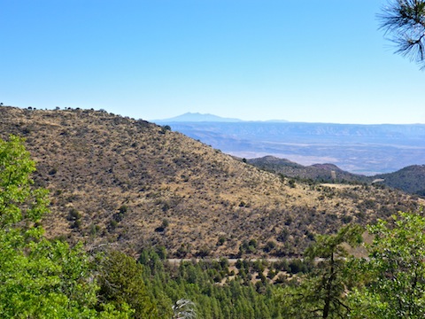
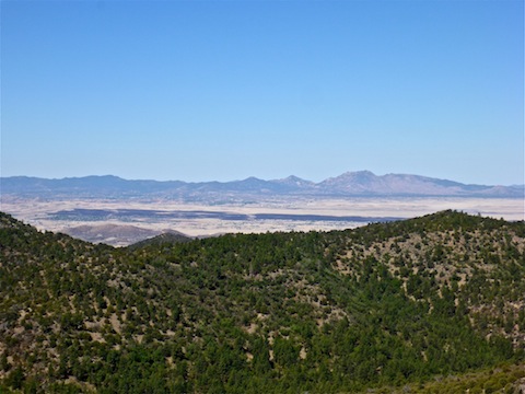
Though not totally shaded, Woodchute Trail #102 had plenty of quality shade between the trailhead and the Woodchute Wilderness sign. The trail was well-maintained, and mostly smooth. As it winds slowly up a spur of Woodchute Mountain, Trail #102 alternately reveals great views of the Verde Valley and Prescott Valley. For better photo ops, there are numerous little use trails to better observation points. Southwest 25 miles, past the Viewpoint Fire burn scar, I could pick out Granite Mountain and Little Granite Mountain. Northeast 50 miles, the San Francisco Peaks were quite distinct.
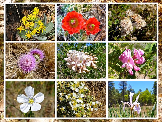
The quantity of flowers gradually increased from none to dense as I hiked north on Woodchute Trail #102, peaking just short of the Woodchute Wilderness sign. Most of the flowers were bush flowers, rather than ground flowers, but color is color! 💐
At the Woodchute Wilderness sign, I was passed by the only other hikers I saw all day, who were headed up to the summit. It looked like there was a trail down to FR 503A, in Hull Canyon, which I hiked on my Black Hills Loop last year. Instead of exploring, I turned west, heading past Woodchute Tank onto Rick Tank Cutoff Trail #104.
Lower Woodchute Tank was dry and Upper Woodchute Tank had very little water.
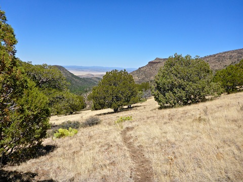
Rick Tank Cutoff Trail #104 descends 1000 ft. in 1.2 miles, between Woodchute Tank and Martin Canyon. It is narrower, and less-defined, than Woodchute Trail #102, particularly where leaves or pine needles have fallen on it. Take your time, though, and you should have no problem picking it out. As Trail #104 meanders down, alternating between grassland, junipers and gambel oak, the views down canyon are fantastic. My favorite part of the day! 🤗
Rick Tank Cutoff Trail #104 intersects Martin Canyon Trail #103 200 yds. east of Rick Tank.
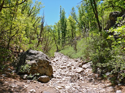
Martin Canyon Trail #103 starts off as half decent jeep trail, but rapidly becomes very technical off roading, only for skilled drivers with high clearance 4x4s. I saw the vehicle tracks, and lost parts, of those who tried. Probably ATVs.
Despite being very rocky, like hiking in a creek bottom, Martin Canyon Trail #103 does not often threaten the structural integrity of one’s ankles, so I made good progress up the gentle slope (600 AEG in 2.2 miles).
Martin Canyon has plenty of shade, and good sitting rocks, so I stopped to eat lunch (a prickly pear pecan R Bar energy bar). As I headed out, I almost stuck my hiking pole in a dead gray fox. He was desiccated, and in one piece, so my I’m thinking rabies got him, rather than a predator, which would have left fox parts scattered for a hundred yards.
I enjoyed the sun glinting through the leaves, but Martin Canyon has almost zero flowers.
Martin Canyon Tank was bone dry, but Turkey Tank — where Martin Canyon Trail #103 breaks out into the open — had plenty of water, muddy though it was.
I took a break at a camp site near the junction of Coyote Trail #101. (I say “near”, as I never actually spotted it, but it is there. Somewhere.) I stopped because I thought I saw bones, but the whiteness turned out to be a salt lick. There were quite a few flies, not just there, but throughout the day. Thankfully just annoying house fly type flies, not biting horseflies. 👏
From Turkey Tank, Martin Canyon Trail #103’s surface begins improving, and becomming less technical for off roaders. It also pitches up, climbing 300 ft. in a half mile, to just above Hickey Tanks. (Which were both bone dry.) There is still shade, but it is much spottier than deeper in Martin Canyon. I got sunburned.
From Hickey Tanks, it’s a little over a mile, past more RV campers, back to the lower Woodchute Trailhead.
After post-hike refreshments, my wife & headed back down AZ-89A and AZ-69 to I-17. Southbound to Phoenix, the Black Canyon Freeway was pleasantly smooth sailing, despite the presence of at least eight DPS troopers on holiday radar duty. They needn’t have bothered the northbound drivers, as it was worse than rush hour gridlock headed north out of the Valley for the Memorial Day weekend. 😳
Directions: From Phoenix, take exit 262 onto AZ-69. Head west for 21 miles. Turn right on Fain Rd. In 7.2 miles, at the stop light, take a sharp right onto AZ-89A, which gets very twisty as it heads up Mingus Mountain. In 12.1 miles, at the summit of the pass, turn left. Take the very next left to Woodchute Trailhead. You may park at the lower trailhead, by the pit toilet, or drive on car-drivable dirt another 0.7 miles to the upper trailhead.
GPS File: Woodchute_Mountain_Martin_Canyon
Distance: 9.71 mi.
AEG: 1,474 ft.
Time: 3h 51m
Hiking Video
Hiking Woodchute Mountain & Martin Canyon from Preston McMurry on Vimeo.