

The last two or three months, I haven’t really had any hike plans: I’ve been making it up as I go along. Last week, I set out to correct that, beginning to plan out my hikes through the end of the year. For this week’s hike, I had settled on hiking Tanner Peak, which is just a few hundred yards from Armer Mountain, in the Sierra Ancha.
That was my plan.
Then some photos of great fall color showed up in my twitter feed, courtesy of @dsoltesz.
My plan changed.
Instead, I was heading north, past Sedona, deep into Oak Creek Canyon, to hike the West Fork of Oak Creek Trail #108.
Sedona is famous for its Red Rocks, but it has metastatized the last 30 years, since I went to school at NAU in nearby Flagstaff. Traffic is so bad, now, that heading south, back into Sedona, cars were backed up a mile from the first stop light. Which is still nothing compared to the living Hell on Earth that is I-17 southbound between Cordes Junction and Phoenix. Dreading I-17 is why I only hike in Sedona every few years.
My wife and I left Phoenix about an hour later than I had hoped, so we got to the West Fork of Oak Creek trailhead at 9:05 a.m. The “Call of Canyon” parking lot was already full, despite the gates opening five minutes earlier. We were the seventh car in line, with what turned out to be a one hour wait. After only one car left in 10 minutes, I got out, put on my hiking gear, and my much more patient wife got in the driver’s seat. I couldn’t do the hikes I do without her loving support. ![]()
For what it is worth, though part of Coconino National Forest, the trialhead is run by a concessionaire, so parking is $10 per car.
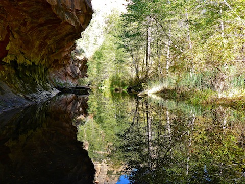
I wore my 5-10 Water Tennies for the hike, which I had purchased before my Aravaipa Canyon through hike last year. It was a good decision, as there are 13 designated water crossings in Trail #108’s 3.3 official miles. It is possible to keep your feet dry if you have good balance, but I twisted my knee pretty good rock hopping a few years ago, so now I just get it over with and get wet.
The first tenth of a mile, to the foot bridge over Oak Creek, is paved. The next .40 miles, to the first creek crossing, is wide, smooth, groomed, hard pack that resembles a golf cart path. Even someone with poor balance, or bad feet, could enjoy the first half mile. I’d even call it wheelchair accessible.
The “Call of the Canyon” trailhead is named after the Zane Grey novel, written while the author was living in Oak Creek Canyon at Lolomai Lodge. There is no longer any trace of Lolomai Lodge, which was located just across the foot bridge.
The trail then passes through the old apple orchard, which is now covered with ferns. There are a number of informational signs.
Just past the orchard are the ruins of Mayhew’s Lodge, which was open from 1923-1968. Many famous people stayed there, including Herbert Hoover, Jimmy Stewart and Maureen O’Hara. Not far away, is the lodge’s barely still standing chicken coop, adjacent to which is a small cave that served as the lodge’s “root cellar”. (Which I assume is a euphemism for where they kept the beer cold during Prohibition.) ![]()
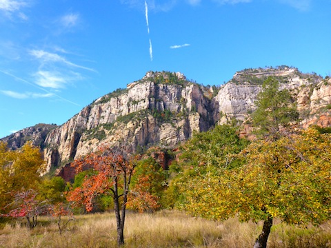
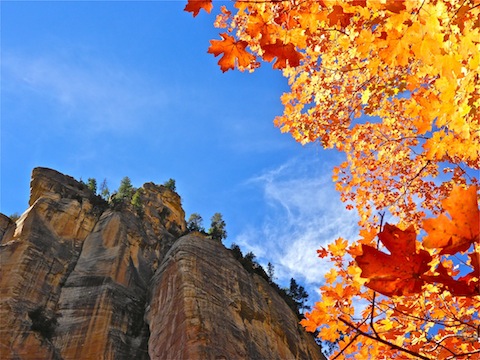
West Fork of Oak Creek reminded me of Aravaipa Canyon, minus the 30-foot high flash flood which scrubbed Aravaipa clean in August, 2006. Where the two beautiful hikes differ, is Trail #108 is well defined the whole 3.3 miles, whereas in Aravaipa you head straight up the creek, picking up animal trails here & there. You could hike straight up Oak Creek, but it will take you a lot longer. I was not there to hike Oak Creek: I was there to see the fall colors!
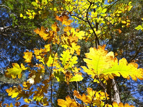
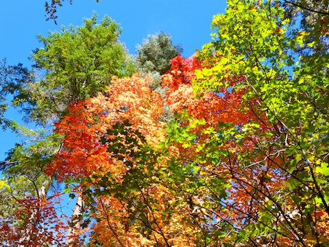
Starting just after 9:00 a.m., the sun was at the perfect place in the sky, regardless of which way the canyon twisted — and it twists 270°, all the way from northeast around to southeast, at different points. Unlike two weeks ago on the Abineau-Bear Jaw Loop, I was blessed with nearly cloudless skies. Except when I was picking my way across Oak Creek, I spent most of my out hike with my head craned skywards. By noon, my neck was hurting. ![]()
The trail surface between the first crossing and the end of the official trail varies from nearly cart path, to some roots, and small boulders, but nothing dangerous or strenuous. I saw many families hiking the whole way, even with children not yet in middle school. Despite the obviousness of Trail #108, it is still marked by many official cairns (3 ft. high, cylindrical, piles of rocks enmeshed in heavy duty chicken wire).
I had planned to possibly do short explorations up a couple of small side canyons — before they started getting steep! — but I took so much time just enjoying the pleasant stroll, that I stuck to the path until it petered out at 3.3 miles, just past the “camping sign”, which warns you need to proceed another 2.75 miles before camping becomes legal. (I had spotted several old camp fires along the way, including in a small cave at the 2.5 mile mark.)
I wasn’t planning on camping, but I continued another mile anyway, hoping to get past my still quite numerous fellow hikers. I had to wade in knee high water a few times, but the flow was very weak. The worst part was fighting through the worst horde of gnats I’ve ever experienced. It was so bad, I had to cover my face with my nasty, smelly, hiking hat. ![]()
I had to pee bad, but there were still anough people about, I didn’t think I could get away with it. So, I climbed a very steep, loam-covered, 30 ft. bluff, where I found some small mushrooms, and very firm, actually sharp-edged, tree fungi.
After returning to the Oak Creek, I turned back about a half mile, before taking a lunch break of a turkey sandwich and Newcastle Brown Ale, with a Dutch stroopwafel caramel cookie for desert.
Having seen everything there was to see, and thus not needing to gather any more material for my video, I hauled ass back to the trailhead, picking up, then pacing, three very fast-hiking canyoneers along the way. That was a good blow, whoever you guys were!
GPS File: West_Fork_of_Oak_Creek
Distance: ~8.00 mi. (guesstimate, as I accidentally deleted my track)
AEG: ~500 ft.
Time: 3h 41m
Lovely, lovely colors and video. Thanks for the compliment … :- )
Beautiful colors!
Yeah, I haven’t see colors like that since I lived back in Wisconsin!