

It’s been way too long since I visited the stunning mountains of northern Yuma County. Almost two years, since I went arch hunting in the Castle Dome Mountains.
Today, I visited the next range north, the Kofa Mountains, in the Kofa National Wildlife Refuge. (“Kofa” is an acronym for “King of Arizona”, a legendary mine located 10 rugged miles southeast of today’s hike.) I honestly think I could do nothing but explore the Kofa Mountains and Castle Dome Mountains, the scenery is so stunning. And it appears some people do, as there are many RV campers parked off the various dirt roads.
From the trailhead, I intended to hike north just over a mile to the west end of Tunnel Mine Canyon. Then head southeast up Tunnel Mine Canyon for a little over three miles, checking out a mining prospect along the way. At an unnamed wash, I would turn south. Just below a low saddle, I would explore a mine shaft. From the saddle, I would descend another unnamed wash to Cereus Tank and Skull Rock, before returning west on Kofa Queen Canyon Rd. to the trailhead. It didn’t look like the unnamed washes would ‘cliff out’, but you never know. 🤔
As usual when heading west, my wife & I took US-60 rather than traffic-choked I-10. It took our SUV 30 minutes to drive the dirt road from US-95 to the trailhead at the foot of Kofa Queen Canyon. Don’t try it in a car.
I started hiking at 9:45 a.m. It was only 37℉ in the Arizona Outback, so I wore a hoodie.
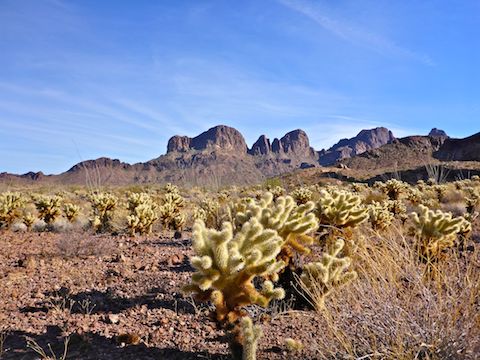
To get to the mouth of Tunnel Mine Canyon, aim between the lonely mountain and the main slope of the Kofa Mountains. The hike north from the trailhead crossed a dozen washes. They were not deep, but they had steep, slippery sides. In between the washes, I navigated a cholla forest. Negotiating the cholla was not difficult, but avoiding the numerous cholla balls on the ground was. I managed not to kick any up on to my calf. 👍
Tunnel Mine Canyon is easy travel. There’s fewer cholla, and more ocotillo and normal Sonoran Desert shrubbery. Still, I managed to bash my ankle really good on a rock. It still stings in the shower days later.
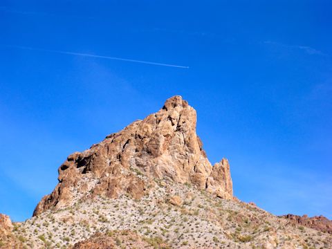
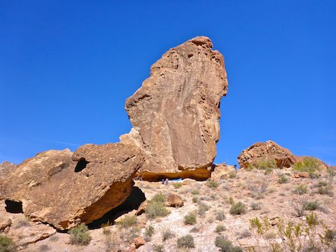
The Kofa Mountains are never ending amazing rock formations, natural arches and holes-in-rock. I stopped often just to take in the view. (And look for big horn.) 😲
A couple of miles up Tunnel Mine Canyon, the topo indicates a prospect. I could not see any signs of it on sat view, nor did I find much when I was on the actual ground. All I found was a brown beer bottle of indeterminate brand, a rusted out 5-gallon can, a glass jar and a couple small sheets of corrugated metal. I think the prospect may have been Tunnel Mine, as I otherwise could not find Tunnel Mine on the topo. Considering it was in a wash, it must have been a placer mine.
As I was filming the prospect area, I heard brush bashing. I turned to see another hiker a few yards away. A serious hiker, with a big pack and nice gear, not a rag bag like me, or a mineral hunting retiree from Quartzsite. He said he camped the night before on Signal Peak. Or was it Summit Peak? Either way, a good haul from where we bumped into each other. That was quite the surprise. I don’t meet too many people in the middle of nowhere.
Even miles up Tunnel Mine Canyon, its slope is gradual, the wash is wide, and travel remains easy. At 4.4 total miles, I turned up an unnamed side wash with a cairned entrance.
The unnamed wash was narrow, with more brush, but still not difficult or stabby. I’ve been in worse. Much worse.
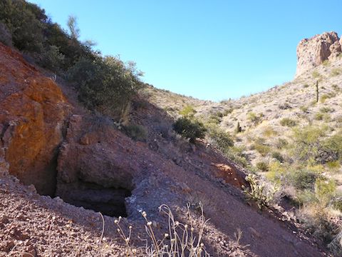
Halfway up the unnamed wash is a mine shaft. It is marked on the topo and visible on sat view. Washes often have downslope mine garbage, “artifacts” if you will, but I found nothing. I was hoping the topo was mislabelled and the adit lead to a horizontal tunnel, but it was indeed a vertical shaft. There was no sign of a head frame, or any support at all, which was surprising given how loose and crumbly the ground was. I low-crawled as close to the edge as I could without falling in, but could not see far down. A selfie stick would have been useful, and not to take “I love me!” video.
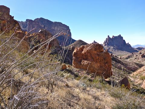
From the saddle above the mine shaft, there was an awesome view down to Kofa Queen Canyon. The wash is brushy and rocky, so I mostly side sloped on big horn trails. I got stabbed once by one of those caltrop-shaped cholla spikes. Weird, because I felt it, but did not see it. I eventually found the caltrop up my pants leg.
Cereus Tank is near the bottom of the wash. Cereus is formed by a cement check dam, with pipes out of the base. At first I thought the tank was totally dry, but there was a small alcove with a foot or two of water. On sat view, I had seen something on the bluff above the Cereus Tank. I thought maybe the object was a rain apron, but in fact it is a camouflage net. It sure seemed like a hunting blind, as it has perfect line of site on Cereus Tank. (Which I believe is illegal.) Then I thought maybe it might be a big horn study hide. Either way, I am reporting it.
Almost down to Kofa Queen Canyon, I noticed a silver bucket on a post, just up slope a bit. No idea what it was. Near the post was a massive, free-standing, boulder, probably 80 ft. wide and 120 ft. tall, with a crawl space underneath. I thought it might be the back side of Skull Rock, so in I crawled. On the other side were some friendly Canadian folks who had rode ATVs in from Quartzsite. They pointed me in the correct direction.
Skull Rock was the next boulder over, and indeed it looks like a skull, with two eyes and a mouth. The mouth is actually large enough to camp in, with a fire. Half buried in the sand like that, it looked like a place Long John Silver would hide his pirate treasure.
It was 3:00 p.m. and Kofa Queen Canyon was already deep in shade as I walked the final 2.3 miles down the road to the trailhead.
Too late to also stop by Palm Canyon, my wife & I drove south a few miles to the Stone Cabin snack stand, which has … had … the best date shakes in Arizona. The snack stand is gone! 😳
There was nothing left of the snack stand other than the Stone Cabin and a few decrepit outhouses, as if the Grinch had looted Whoville, not even leaving a can of Who hash. (An agent at the Border Patrol checkpoint said the snack stand was not set up at all last fall like it used to be, so it must be permanently closed.) 😥
After a late dinner in Wickenburg, we finally got home at 9:00 p.m. and immediately went to sleep. In my case, stink & all.
Directions: You will need an SUV, or better, to reach the trailhead. From Quartzsite, head south on US-95 to milepost 85. From Yuma, head north on US-95, past the Border Patrol checkpoint and Stone Cabin, to milepost 85. Turn east at the brown sign for Palm Canyon. Palm Canyon Rd. is car drivable dirt. At 3.4 miles, by the kiosk, if you have a car, stop, or just visit Palm Canyon. If you have an SUV or better, turn north onto Kofa Queen Canyon Rd. At 8.0 miles, just as you reach the first hill, turn right into the open camping area. That is the trailhead. To continue driving on Kofa Queen Canyon Rd. all the way to Skull Rock, you will need high clearance 4WD. It is non-technical. Skull Rock is at 10.2 miles.
GPS File: Tunnel_Mine_Canyon_Skull_Rock
Distance: 9.00 mi.
AEG: 1,119 ft.
Time: 4h 11m
Hiking Video
Driving Video
Driving Skull Rock Road, Kofa Mountains, AZ from Preston McMurry on Vimeo.
Rock Heaven with nice formations.
Good one, cool place!
I try to find cool places. Hiking the same trails in Phoenix gets old after awhile.