

I’ve had Tanner Peak on my list for two years, since I hiked Armer Mountain, looking for the West Point C-47 wreckage.
The last time I was out here, did not go so well. 😂
The summit of Tanner Peak is less than a mile from the summit of Armer Mountain. You could do both in one hike, but it would add 1000 AEG of bushwhacking to your day. 1000 AEG on a trail is not so bad, but bushwhacking it makes much harder, slower & physical. Going up & down a trail is legs & lungs, but doing it through brush and over rocks is a full body workout, likely involving plasma loss.
I don’t know what the northwest slope of Armer Mountain is like, but I do know the wash up from Sawmill Flats Campground is full of razor blades, so if I was to do both Tanner Peak and Armer Mountain, I try it instead from the Rose Creek Campground. At least most of the mileage would be on old jeep trail.
Most of the Tanner Peak hike is on old jeep trail. But, if you think about it, what is the difference between jeep trail and single track, other than width? If your goal is to see natural wonders, and get a good workout while doing so, what you are flapping your feet on should not matter. 😉
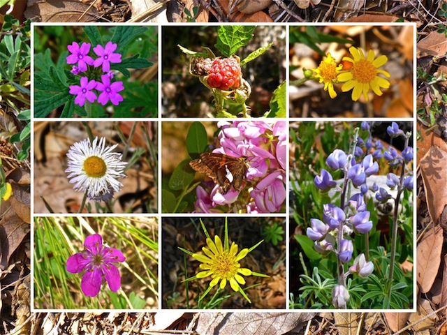
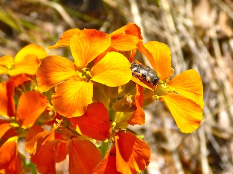
Top Row: spreading phlox, red raspberry, {unknown}.
Middle Row: fleabane, New Mexico locust, silvery lupine.
Bottom Row: pineywoods geranium, yllow salsify.
The jeep trail is unmarked, but I believe it is FR-95. It connects direct to the Young Highway, within feet of the Rose Creek Campground access road. I’ve driven past it before, even when looking for it. There is no place to park on FR-95, and the first quarter mile west from the Young Highway is the most rugged section of its whole six mile length, so best start from the campground like I did.
From the Rose Creek Campground, hike south, up slope, past the pit toilet. It’s a steep little climb, and quite slippery on all the pine needles.
Turn north onto FR-95, which is mostly smooth sailing. There are some rocky sections, and some that are smooth as glass, but I rarely used my poles downhill, on the return trip. Instead of concentrating on your footing, enjoy the scenery.
Along FR-95, there are fantastic views of Carr Mountain,Baker Mountain, the lookout tower on McFadden Peak, Jack Mountain, Hopkins Mountain, and various slopes of Armer Mountain.
FR-95 is level for about .75 miles, before dipping about 200 ft. to some access roads to private property, on which I saw several barns / hunting cabins, and even a pretty nice RV. One of the lots is for sale. (It’s not listed on Zillow.)
At 1.5 miles, FR-95 turns west, away from the private property, and begins switchbacking up hill, about 800 ft. in a mile and a half.
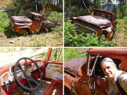
Halfway up the climb, on the right hand side of the trail is an abandoned truck, in pretty good condition as such things go. Judging by the grill and headlights, I’m guessing a 1958-60 International A110 or B120. I didn’t bother checking for a VIN.
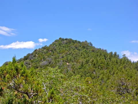
FR-95 levels out for the next 1.5 miles, until it begins climbing up the Deer Creek drainage, along the east slope of Tanner Peak. You could turn west at any time, and take Tanner Peak head on, but it will be even steeper, rockier and more tangled than the route I took. There’s a real nice camp spot — flat, grassy, shaded — about halfways up the drainage.
About 5.5 miles up FR-95, it reaches a saddle between Tanner Peak and Armer Mountain. If you were to double summit, this would be where you start ascending Armer. The jeep trail peters out a few hundred yards past the saddle.
Just before the saddle, turn right, and head up the spine of Tanner Peak. It’s only a quarter mile to the summit, but it is a steep, tangled, rocky, 300 ft. climb. It’s not nearly as bad as coming at it from the side: I’d know, since that is the way I started down, until thinking the wiser of it.
The topo and my GPS map have Tanner Peak’s summit about 50 ft. east, and 20 ft. down hill, from where I found high ground. There’s some shade there, and a couple of rocks that make a good back rest, so I sat for an hour, relaxing, eating, and checking my twitter feed. (Depending on which way I rotated my phone, the reception varied from 1-3 bars; there’s no reception anywhere else between Rose Creek and the summit.) It was too tangled on top to search for a summit log.
There’s a fair number of hornets / wasps — not sure which — on the summit. They were non-aggressive, but buzzing all about, along with flies, while I took my break. I even had one hover for a few seconds, about 4″ from my cheek, sizing me up. I really wanted to ease my camera out of my pocket to take a picture, but figured it was wiser to remain still & not provoke him. Pretty cool.
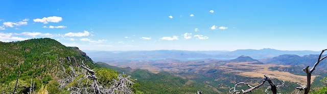
After my break, I took in the views. Armer Mountain was obvious, since it was right next door. Turning clockwise, I saw an large sandy area, in the distance, and wondered what sort of flat that must be until realizing it must be the copper mine in Globe. The communities at the Tonto National Monument and Roosevelt Lake were obvious. I could not see Roosevelt Dam, but beyond that, Canyon Lake was visible, and on a direct line past that, Flatiron. (37 miles away.) Wow, that was cool! Four Peaks was also obvious, and Dutchwoman Butte, just below in the Tonto Basin. I could see a mountain range to the west, through a gap in the Mazatzals. Maybe the Bradshaws?
Like I said earlier, I tried heading down the side of Tanner Peak. At one point, I tried to ease over a rock. I landed awkwardly, and though I did not get hurt, could have easily broke my leg. That would not have been good. I’ll gladly take a bleeding arm over a shattered tibia any day. Yep, best to take the spine back down, off the summit.
Once back on FR 95, I hauled ass back to the Rose Creek Campground, pausing only for a few short breaks. Despite the temperature never getting above the low 80s, the sun was quite intense. Thankfully, there was quality shade throughout the day, all along the trail.
There were also a lot of flowers. 90% of the species were either lupine or tree flower with which I am unfamiliar. I don’t think it was ironwood. Miles of FR 95 are strewn with leaf litter from that tree. The only other species with more than a few instances were a tiny white flower, that appeared in clusters. There were some wild raspberries near the wrecked truck.
I started hiking at 8:40 a.m. — it’s a long drive from Phoenix — and finished about 4:30 p.m. A quick dash back down the mountain, the along Roosevelt Lake, got my wife & I to the town of Tonto Basin in time to enjoy some air conditioning, ice cold beers, and a delicious Big Daddy’s Pizza.
Finally dragged in about 8:30 p.m. Long day. But a good one. 👍
Directions: Depending on where you live in the Valley, there are two general ways to get to the Rose Creek Campground: From the south & east Valley, take US-60 to Globe, then AZ-188 north towards Roosevelt Lake. From other parts of the Valley, exit the Loop 101 at Shea. Go east on Shea to the Beeline Highway (AZ-87). Go north on the Beeline Highway for 46 miles to AZ-188. Go east on AZ-188 for 46 miles, passing through the small communities of Jake’s Corner, Punkin Center, Tonto Basin and Roosevelt. Turn north onto the Young Highway (AZ-288). The road is narrow & twisty as it climbs into the Sierra Ancha, so mind your speed. In ~22 miles, as AZ-288 crests the climb, it turns to car drivable dirt. In ~2 more miles, on the left, will be a sign for the Rose Creek Campground. Be careful if you are not driving an SUV or better. A quarter mile down the road will be heavy metal gate, turn left, crossing Rose Creek, into the campground.
GPS File: Tanner_Peak
Distance: 11.25 mi.
AEG: 2,200 ft.
Time: 6h 00m
Hiking Video
Hiking Tanner Peak, Sierra Ancha from Preston McMurry on Vimeo.
Keep up the good work big brother.
Any place away from other people is a good one. Could have done with out the bozo camped in the middle of the road. That will definitely make a future Phoenix Asshole Drivers video! 🙄
I wish I could go on the hike to see the incredible flowers. The trail head was nice and shady and quiet.