

From the Fourr Cemetery and Oatman Massacre sites, Stoic and I moved on to Sundad.
Sundad is on Agua Caliente Rd., which is dirt, but car drivable. From the south, Sundad is 10.5 miles north of Hyder Rd.; from the east, it is 45 miles southwest of Buckeye. We drove north, since it is not far from Oatman Flat.
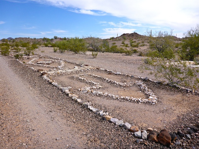
There’s not much information on Sundad available on the internet, but it was established as a tuberculosis sanitarium in the 1920s. With TB being highly contagious, the distance from Phoenix kept healthy folks safe, while it was felt the dry, warm, air would be beneficial to the patients. The sanitarium did not last long. In more recent decades, it has been a party spot for off roaders. That is not as bad as it sounds, and is actually quite cool, as they have turned the rocks and many bottles into interesting rock art designs. (Just look at sat view!) “Sundad” is spelled out several times, and there are circles, diamonds, wheels, flowers, sunrises, arrows, and many other designs. Pretty cool! ![]()
Watch your step: Lots of nails as well. ![]()
I recommend you park just outside of town, then walk in, to avoid punctures. ![]()
I had noticed a few whazzit’s on sat view, and on close up inspection, they turned out to be grated mines covered by the BLM’s Fun Prevention Police, plus some associated workings. Stoic was surprised when he looked down a shaft, and saw eyes staring up at him. ![]() (It was an owl.) Must be common for owls to roost in shafts, as I had previously seen them do the same at the Mint Shaft, near Wilhoit.
(It was an owl.) Must be common for owls to roost in shafts, as I had previously seen them do the same at the Mint Shaft, near Wilhoit.
As with many places in Arizona, it almost goes without saying, there was also mining in the area. Not sure when that started & ended, but it could be around the same time as the sanitarium as there are cement tanks next to the two shafts I found, as well as many prospects. Not sure what a cement tank would be doing up hill from a shaft? Unusual.
The entire Sundad site is only 500 yards south-to-north, and maybe 100 yards wide.
Then it was down to Agua Caliente. I had explored the ruined cabins along the road a few weeks ago, but today we also checked out some ruins further up the very rocky and rather steep hill. Turns out that there was only one identifiable cabin wall on the hill, but many large cairns (as in 4+ feet tall piles of rocks). In fact, from higher up on the hill, we were able to notice something not obvious to the naked, road-level, eye: Large cairns on each of the Agua Caliente Mountain’s summits.
With 97° predicted for Gila Bend, it was surely that hot further west, and the heat was starting to get to me. Despite drinking plenty of water and lime-cucumber Gatorade (serious!), I was actually feeling a bit woozy. We briefly checked out the various foundations (ghost towns?) along Hyder Rd., before pulling into the lot of the cantina at Dos Palomas. It was closed. As we were headed back to the Xterra, it opened. ![]() (The cantina opens at 2:00 p.m.) Though they had the new cinnamon & horchata Blue Moon beers, I opted for a cruddy beer: Tecate. Then another. Then a third. (I was not driving.) Nothing refreshes quite like a bad beer on a hot day.
(The cantina opens at 2:00 p.m.) Though they had the new cinnamon & horchata Blue Moon beers, I opted for a cruddy beer: Tecate. Then another. Then a third. (I was not driving.) Nothing refreshes quite like a bad beer on a hot day. ![]() Our total damage for a bottle of tea, three beers and a bag of chips was only $9.75! Feeling human again, we bid adios to our friendly bartender Carmen.
Our total damage for a bottle of tea, three beers and a bag of chips was only $9.75! Feeling human again, we bid adios to our friendly bartender Carmen. ![]()
Distance: 3.97 mi. (total for the day)
AEG: 523 ft.
Time: 2h 30m
Ghost Town Video
Sundad Ghost Town, Maricopa County from Preston McMurry on Vimeo.