

Counter-clockwise from Bronco Trailhead, this is the 2nd segment of the Maricopa Trail.
Heading into this week’s hike, I’d heard that flowers were going nuts, so I figured I should figure out a good #flowerporn hike. All the good flower hikes I did in 2018 — like the Prescott Circle Trail between Thumb Butte & Katahn Rd. — were at higher elevations, and the National Weather Service was predicting snow above 6,000 ft.
Besides, I try not to repeat hikes too often — particularly if I’ve made a hike video about it — so that ruled out Palo Verde Trail #512 at Bartlett Lake, which I did in 2017.
The best variety of flowers I ever found was on the Cave Creek / Skunk Tank Loop, also in 2017, but I figured I might find some decent flowers near by. I also needed some miles, as I’d been slacking.
So, I hit on the idea of hiking the Dragonfly Trail across Cave Creek, then through the Jewel of the Creek Preserve to the Spur Cross Trail, which I would follow south out of the Spur Cross Conservation Area, to the Maricopa Trail, before finishing up with the Go John Trail through Cave Creek Regional Park (CCRP). It is aboout 12 miles, one way. No way would I want to do an out & back, so my always supportive wife would shuttle for me. 🤗
My wife & I left Sunnyslope at the usual 6:00 a.m., but since it’s only a 45-minute drive to Spur Cross, rather than the 2-3 hours my hiking drives often take, we arrived early in the Town of Cave Creek. So, on the way into town we stopped for breakfast at the Wagon Wheel cafe for breakfast. The food was cheap, hot & filling. 👍
When there was finally enough light to hike, it was cloudy, chilly & drizzling. And I had forgot my hiking hoodie. (The thin hoodie material retains enough body heat to keep me warm, even in snowy weather.) So, we sat in the car at the Dragonfly Trail trailhead, opposite Spur Cross Stables, for an hour, watching other folks, bundled up like Michelin Men, head out on their hikes. 🥶
Eventually the drizzle let up, though it remained overcast for hours, and breezy all day. I started hiking just after 9:00 a.m.
Dragonfly Trail is more a small web of trails in & about the Jewel of the Creek Preserve, than it is a single trail from A to Z (like Spur Cross Trail is.) The Preserve, an Adubon Society-recognized riparian area along Cave Creek, is a popular birding site, with dozens of species, including one — the Song Sparrow — apparently found only there.
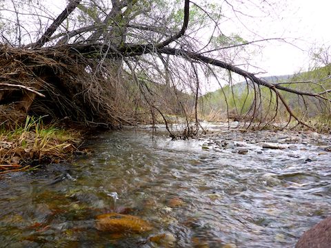
Taking the most direct Dragonfly Trail route to the Spur Cross Trail intersection, it is 1.6 miles with a single, moderate, 250 ft. climb out of the Cave Creek drainage. Cave Creek was a few inches deep, and still running pretty good. The wood plank ‘bridge’ had been replaced, so I took that rather than a rock hop crossing. (At least a half dozen of the wood plank bridges had been wiped out in February’s flash floods.)
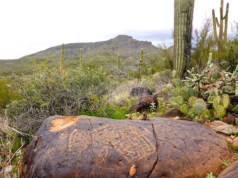
Just after crossing Cave Creek, there is an adit (a tunnel opening) in the bluff wall. The adit, part of the decommissioned Maricopa Mine, is easy to get into. Surprisingly, in today’s risk averse society, it the adit is not gated. It doesn’t go in far, and there is nothing in there, no stopes or dangerous unmarked shafts. Not even any artifacts. Basically, mine exploring for kids. 👨👩👧👦
The flowers I spotted on Dragonfly Trail included desert globemallow and blue dick. (Yes, that is what Dichelostemma capitatum are called.) 😆
Taking flower photos with my crappy pocket camera is difficult enough, even on the macro setting: Poor light and breeze blowing light flowers about, makes it even more difficult.
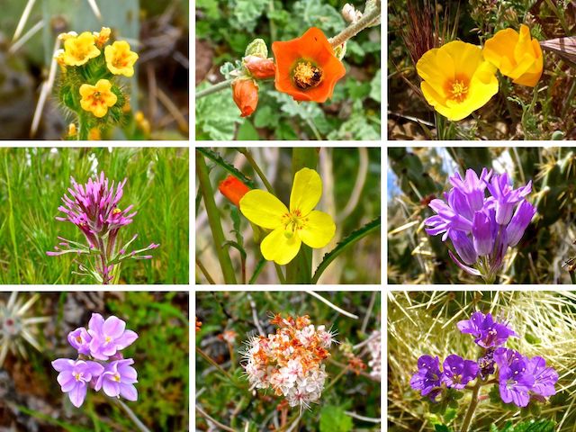
Top Row: fiddleneck, desert globemallow, Mexican gold poppy.
Middle Row: owl clover, California suncup, blue dick.
Bottom Row: blue dick, flat top buckwheat, scorpionweed.
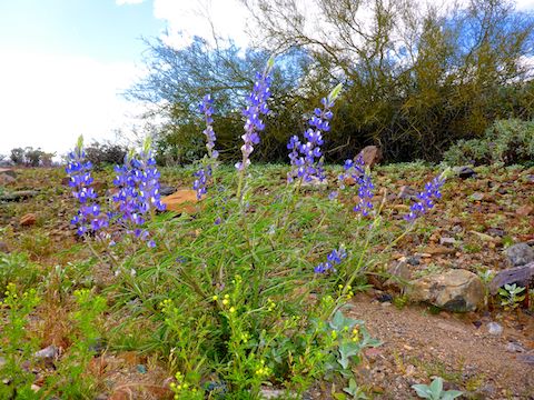
Besides the flowers shown above, the #flowerporn included brittlebush (of course), tons of globe chamomile, lupine, dandelion, London rocket (love that name!) and a couple of more species I am clueless on. Plus blue dick. (No giggling!)
There was a memorial bench, and many signs — you can’t get lost! — at the intersection of Dragonfly Trail and Spur Cross Trail.
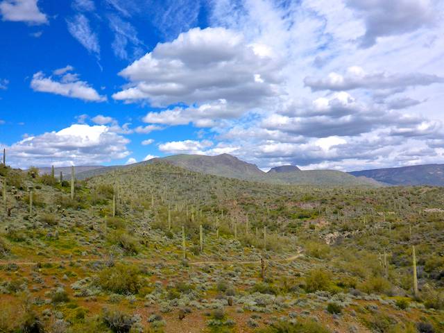
Spur Cross Trail is the backbone trail, which most other trails intersect, in the Spur Cross Conservation Area. Spur Cross Trail stretches 5.2 miles from Tonto National Forest, south to Rodger Creek. North to south, it is 700 AEG; south to north, 450 AEG. I headed south.
It is 2.7 miles and 400 AEG from the Dragonfly Trail intersection to Rodger Creek, most of the AEG coming in the middle ⅓, on the climb to the Elephant Trail intersection. (Also with a memorial bench and festered with signs.) It was my favorite section of the day, as I was not hiking through scrub, or a luxury development, or crowds of people. The lighting was still awful, but the views were nice. ⛰
There are five gates on this hike. None require struggling with a loop of barbwire to get them closed: You can walk right across them. (Cattle not so much.) The first gate is located at the south boundary of Spur Cross Conservation Area, just before Rodger Creek.
Maricopa Trail is co-located with the Spur Cross Trail for its 5.2 mile length. (Maricopa Trail, itself, is a 315-mile loop trail around the Phoenix metro area.)
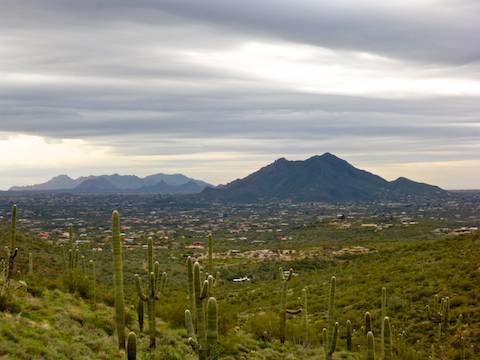
The Maricopa Trail portion of this hike is 4.2 downhill miles from Rodger Creek to the boundary of Cave Creek Regional Park. Part of it is on old jeep trail, part on pavement, and part on regular foot / MTB / horse trail. Not exactly exciting, especially when it passes by the nascent luxury development — 1-2 acre lots! — but it is still exercise. Even before the roads were put in, it was not the most scenic terrain: just desert scrub. But there are good views of Apache Peak, and the sun had finally made its debut. 🌤
Note that there currently is a luxury development bypass that runs from Gate #2, at Cahava Rd., south to Gunsight, where it rejoins this route just before it intersects with Go John Trail in CCRP. (Gunsight is the small peak southeast of Apache Spring.) It looks like the bypass may shave a mile off this hike’s total distance.
The Maricopa Trail intersection with Go John Trail is marked by, yes, you guessed it, another memorial bench and multiple signs, both directional and “don’t be bad”.
From the Maricopa Trail, Go John Trail is 2.2 miles to the Go John Trailhead, or another ½ mile to the CCRP nature center, where snacks and refreshing cold drinks are available. The last of the three small climbs on this hike is 300 ft. in a little over a mile from the Maricopa Trail to an old mine. (You can see the gated shaft, and yet more signs warn you away.) 🙄
I found the best flowers on Go John Trail between the old mine and the CCRP nature center. Not only was the sun now bright, but the flowers were healthy, colorful & open. To photograph one cluster of lupine, I actually laid half in the road. 💪
If you are a strong hiker, with a good bit of endurance, a Spur Cross to CCRP out & back would be good distance (23 miles) without an undue amount of elevation gain (2500 ft.) For moderately strong hikers, like myself, a key exchange or shuttle hike is the way to go.
Spur Cross Directions: From Loop 101 / Pima Freeway, head north on Cave Creek Rd. for 12.2 miles. Just as the road curves east into ‘downtown’ Cave Creek, turn left onto Spur Cross Rd. Take the next right, then a quick left. The small Dragonfly Trailhead is 3.7 miles ahead on the left, opposite Spur Cross Stables. The final mile is semi-paved but car drivable. You can park for free, but I went ahead up to the gate a ¼ mile on and paid the $3 / person fee anyway, because its pocket change and helps keep the park nice. 👍
Cave Creek Regional Park Directions: From Loop 101 / Pima Freeway, head north on Cave Creek Rd. for 9.6 miles. Turn left on Carefree Hwy. (From Spur Cross, head back to Carefree Hwy., and turn right.) In 1.7 miles, turn right on 32nd St. The fee station is in 1.6 miles. It costs $7 / vehicle. The Nature Center is in ¾ of a mile, while the Go John Trail is a ½ mile past that.
GPS File: Spur_Cross_to_CCRP
Distance: 12.23 mi.
AEG: 1,126 ft.
Time: 4h 07m