

I lived in southern California — Rancho Palos Verdes and Torrance — in the late 70s, but I don’t recall ever having gone for a hike there. Not then.
I’ve visited California off & on since, to visit family, or for business. The only hike I can recall, of any sort, was a 1.39 mile exploration of an old ranch house ruins in Del Dios, overlooking Lake Hodges, in 2013. I walked further on day trips to San Francsico.
Now that I make it a goal to get in a hike wherever I travel, things are different.
My wife & I were back in San Diego for our grandnephew’s first birthday. We stayed at the Hilton on Harbor Island, across from the airport. It was convenient to I-8 to & from Arizona, plus I-5 up to La Jolla, where the festivities would take place.
Since the only time available to hike would be the morning of the birthday party, I wouldn’t have time to head out to Otay Mountain, or even back to the Elfin Forest. I had to find something closer, so I would have time to shower and not smell like our grandnephew’s diaper when we showed up. 😉
I thought about hiking the cliffs along Point Loma, or urban path walking to Liberty Station, on the airport’s west side. Eventually, I settled on a hike in Mission Trails Regional Park.
Doing a loop of South Fortuna Mountain and North Fortuna Mountain looked like the best option, with moderate distance and decent AEG. But because I need to take my wife into consideration, I couldn’t start from the bathroom-less trailhead on Claremont Mesa Blvd. Starting from the visitor center just off Mission Gorge Rd., on Father Junipero Serra Trail, would be necessary. As that would add distance to the hike, I would likely need to drop North Fortuna Mountain from the loop. (Though I kept it on my GPS in case I set a speed record.) 🏃🏻
I started hiking bang on 8:00 a.m. Parking along Father Junipero Serra Trail was already full, and the dirt visitor center lot was filling quick.
I thought the Visitor Center Loop Trail started out the back of the dirt lot, but it doesn’t. It starts right at the gate. If you are not looking closely, you will miss it, just like I did. It is only .40 miles around a small knoll to the Jackson Drive trailhead. (No toilet, but if you aren’t leaving anyone behind, like I did, that may work better for you.)
Starting on the Visitor Center Loop Trail, and throughout this hike, there are “Stay on Trail!” and “Respect Plant Restoration” type signs regularly spotted along the trail. (Regardless of whether the trail is actual trail, or wide gravel road.)
If you are properly hydrating during your hike, both respecting the signs and your pants could become an issue. Even if your sense of dignity overwhelms that of your civic virtue, probable embarassment and / or subsequent ‘public urination’ charges, will convince you to ‘tie a knot in it’ instead. 👮🏻
Yes, the trails in Mission Trails Regional Park are heavily travelled. Not to the sardine-packed levels of Piestewa Peak or Camelback Mountain, but heavy nonetheless.
From the Jackson Drive trailhead, follow the wide gravel road — known as the San Diego River Trail — downhill to … the San Diego River. There is a small wash on the west side of the road, and that was audibly moving water. Not sure where it ended up though. Certainly not the river. When I crossed, it was bone dry. If the San Diego River happens to be running, cross using the low cement wall about 100 ft. to the west (downstream).
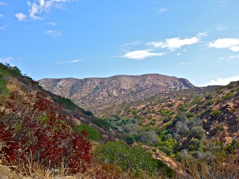
After crossing the San Diego River, the wide gravel road continues up hill, 350 ft. in .50 miles. It was a very similar grade to North Mountain, in Phoenix. It’s a good warmup for the climb up South Fortuna’s steep southern approach. (Which, from the gravel road, appears sheer.)
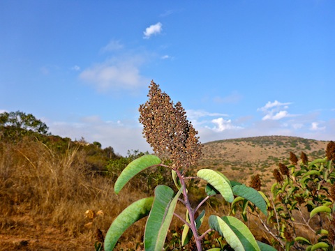
Very, very few flowers on the South Fortuna Mountain Loop. At least any flowers with color other than brown. Wild buckwheat, was everywhere though. (If wild buckwheat has colorful flowers, I’ve never seen them: They’ve always been brown for me.) This hike’s #flowerporn is definitely rated G! 😒
As with any other urban trail system, there are many ways to get from A to Z. Oftentimes, many of the trails are informal and unmarked. In the case of the South Fortuna Mountain Loop, every intersection was thoroughly signed, with trail name, direction, distance to the next intersection, etc.
At the top of the wide gravel road, I turned right on the Suycott Valley Trail, which is a normal single track foot trail, that starts out following a wood rail fence line. It’s a short, fairly steep descent. The trail is shared with mountain bikers, so keep the eyes in the back of your head open for anyone blasting downhill. I only passed guys pushing their MTBs uphill.
At the bottom of the hill, is the where the lasso handle ends and the loop begins. If you turn left, continuing north on the Suycott Valley Trail, you will be doing the South Fortuna Mountain Loop clockwise. I turned right, to go counterclockwise, towards the Stairway to Heaven.
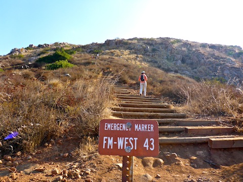
The South Fortuna Trail follows Suycott Wash downstream for a few hunderd yards, before crossing a bridge built by the Boy Scouts. After crossing the bridge, the trail gets rockier, and begins climbing a fairly steep 150 ft. in .40 miles. After levelling out for a few hundred feet, where the trailside boulders are closest, you will be at the foot of the Stairway to Heaven.
The Stairway to Heaven is several hundred steps to a false summit of South Fortuna Mountain. The steps do not last long, but are very steep, 300 ft. in only .16 miles. (Equivalent to an 1800 ft. mile.) There are very few switches. It’s basically straight up. Several times you may need to use three points of contact to get up a small boulder. At least this fat man did.
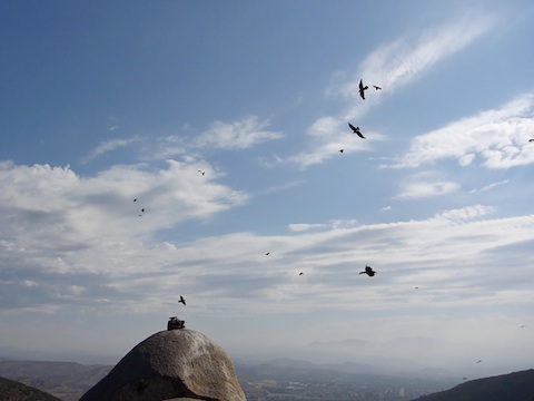
At the false summit is a large boulder. Behind the boulder is a great view of the San Diego River and Father Junipero Serra Trail, 600 ft. below. The boulder shields you from view of the South Fortuna Trail, so I took advantage of the opportunity to take a leak. Hopefully, none of the ants below, in Mission Gorge, had binoculars. 😁
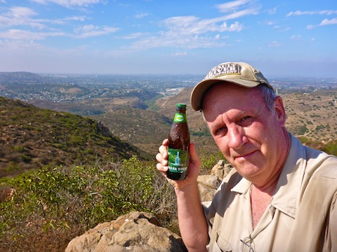
From the false summit, the trail continues up, but at a more enjoyable gradient, to the true summit, which is marked by yet another sign. On a clear day, you could see downtown San Diego and the Pacific Ocean, but it was hazy towards the coast.
I spent a few minutes enjoying the view. I did not actually consume my summit brew because I was still sweating out all the beer I drank on Harbor Island the night before. 🍻😅
After getting my breath back, I headed north off the summit. The trail down to the power lines, changed back to rough jeep trail. The power lines are in a saddle between the South Fortuna and North Fortuna summits. It is 300 ft. in .50 miles to the top of North Fortuna Mountain. You can then come back to the powerline, or extend the loop. Extending the loop will add 2.2 miles to your hike. Due to time constraints, and much higher than anticipated temperatures, I completely skipped North Fortuna.
The rough jeep trail that parallels the power lines is sand over rock, which is the slipperiest of surfaces. Take care with your footing. Luckily, I managed to haul ass without falling.
When I reached the bottom of the powerline jeep trail, I turned south on Suycott Valley Trail. The segment was obviously much more popular with mountain bikes than hikers, but I encountered no MTBs. I was actually kind of bummed, because the whoops would have made for some good action shots. There are six bridges in less than a quarter mile, as the trail winds back & forth across the wash. Just before closing the loop, there is a picnic area, well-shaded by California Live Oak. (Knowledge gained due to the Boy Scout troop that wandered by while I was resting.)
After closing the loop, I backtracked the ‘handle’, uphill along the wood rail fence, down the wide gravel road to the San Diego River (where I took a final break), up to the Jackson Drive trailhead, then back along the Visitor Center Loop Trail to where my patient wife awaited. 🤗
GPS File: South_Fortuna_Loop
Distance: 6.61 mi.
AEG: 1,506 ft.
Time: 2h 35m
Hiking Video
Hiking South Fortuna Mountain, San Diego from Preston McMurry on Vimeo.
I liked to action shots of your hiking! It was a hot day, but nice in the shade.
Shade is more precious than gold!