

In my constant search for new things to check out, where I won’t have to fight hordes of perfume-reeking, boombox blasting, spandex-stretching weekend warriors, I noticed something called “Smith Brothers Mine Road”. Not even dignified with a Forest Road number, it runs east from Wagoner Road, about six miles south of Walnut Grove, on the west most edge of the Prescott National Forest. The road is just a few miles north of the Paxton Place Mine and Camp Bird Mine.
I could not find any sort of Smith Brothers Mine in Yavapai County, or the Bradshaw Mountains, on Mindat.org. I did find a “Smith Brothers #2” — as well as #3, #4 and #5 — on TheDiggings.com, which indicates it has been closed since 1987 and was officially classified as abandoned/forfeited in 1993.
The Smith Brothers Mine #3, #4 and #5 are located at 10N 2W 019 SE of the Gila-Salt River Meridian, while Smith Brothers Mine #2 is in the NW aliquot of that same section. I can find no explanation why there are three claims in the same location; I suspect two of them are actually in the NE and SW aliquots. In much simpler terms, Smith Brothers Mine is between Cherry Creek and Minnehaha Creek.
Granted, Smith Brothers Mine was a placer claim, but on the topo, there are no mine, adit, shaft or even prospect symbols from older mines. (The Bradshaw Mountains have been mined since the 1860s.) I did see some ruins and/or garbage on satellite view.
I like exploring in this area, but despite 3500+ foot elevation, it gets quite hot, so the last time I was out here was in early June, when I explored the Silver Dollar Mine.
I don’t know if it was the time of year, or time of day, or a combination of both, but the drive south on Wagoner Road melted my eyeballs, the sun was so low, and bright, and directly back up the road into my face. I’m glad there was no oncoming traffic … or cliffs for that matter. Wagoner Road is paved the first 11 miles, to the old school house, and is smooth dirt thereafter. A car could drive it as far as Campbell Flat. My wife & I stopped just short, at Cherry Creek.
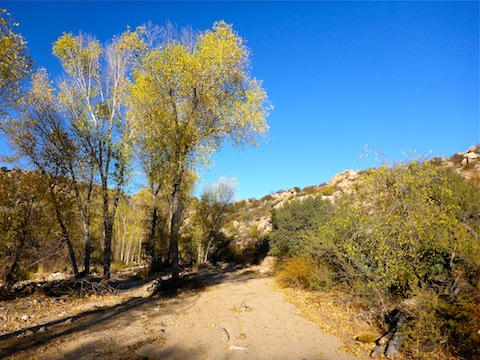
I walked north in sandy-bottomed Cherry Creek for a half mile. When I encountered a fence I turned up a small wash, until I encountered another fence. There are fences all over this area. I ended up low crawling four of them. I gigged my forehead once, and my lip another time, ironically on nearby catclaw, rather than the barbwire itself. ![]()
Travel was generally pretty easy: The area is mostly grassy, with occasional thickets of catclaw. There innumerable washes, but they are most rather shallow (5-10 ft. deep), but with steep sides. Shade is provided by scattered trees.
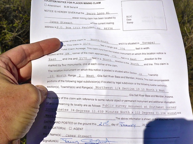
Eventually, I stumbled across the marker for the southwest corner of the Perro Loco #1 placer claim. (Claim markers are typically PVC pipe with an attached weather proof container, containing the claim paperwork.) Perro Loco #1 is basically the western third of Smith Brothers #2. As placer claims look for surface minerals, usually gold, typically where water flows, it seemed odd to find that marker on a spur. There was a survey marker, dating to 1938, immediately adjacent to the claim marker.
50 yards southwest of the claim marker was what on satellite view looked like it might be a prospect. Instead, it was just a very small wash with some exposed stone.
200 yards west of the claim mark, was what looked on sat view like it might be some ruins. Indeed, it was. Quite ruined ruins, at that.
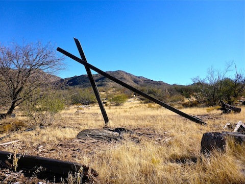
The ruins stretch for about 200 yards along Smith Brothers Mine Road. Amongst the ruins I found:
- A two-hole shitter with no pit below seat level. If there were turds there, they are now dust in the wind. A stone-lined walkway led over a small rise to the other ruins.
- Two tubs, adjacent to a ladder platform. I thought the platform might be for an above ground pool — what do I know? — but now I think it might have been for a water tank suspended above the tubs. (Kind of like our showers in Kurdistan.)
- Many small engine parts and two AC units.
- Several small plastic containers of dried out paint, like for art, not maintenance.
- A sign for a Peoria High School BBQ fund-raiser.
- A real estate sign. I think this property has what realtors refer to as “good bones”.
- One possible grave, unmarked.
I was disappointed there was no sign of mining. ![]()
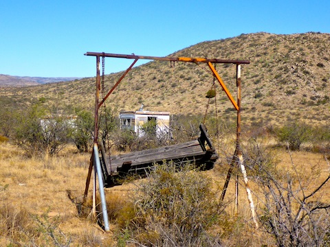
A few hundred yards east, on Smith Brothers Mine Road, is the gated Prescott National Forest boundary fence. The only “No Trespassing” sign I saw all day was off to my left, but I wasn’t headed that way, so I figured I was good. Just beyond that, on an elevated point above Minnehaha Creek was what I thought might be another possible mine.
It wasn’t. What I found were two small campers, mounted on wooden platforms. Just opposite was a swingset. Yes, a swingset. In the desert. I looked down in the canyon, and the sight lines were perfect. I had seen some deer earlier, and so to my Wisconsin eye, it looked like a deer camp.
I started down into Minnehaha Canyon, as I had considered making a loop of it & Cherry Creek Trail #214. But the brush got too thick & stabby, so I headed back up.
After lunch, I followed the contour line south, back to my trailhead.
On the way home, we of course stopped at the T-Bird Cafe in Peeples Valley, where I had a delicious fennel sausage sandwich and two BYOB Lagunitas Brown Shugga Ales for early dinner. ![]()
Distance: 5.87 mi.
AEG: 499 ft.
Time: 2h 55m
Hike Video
Exploring Smith Brothers Mine, Yavapai County from Preston McMurry on Vimeo.