

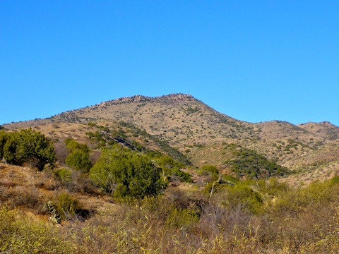
The Dripping Springs Mountains are not an area I had heard of until one day I was randomly perusing a topo map, and noticed the range wedged between the massive Ray Mine and the Pinal Mountains. The Dripping Springs Mountains have a number of small peaks, and many mines. The peaks, of which Scott Mountain is tallest, are not very prominent, but generally involve 7-10 mile hikes of 2000 ft. AEG (accumulated elevation gain), round trip. So, a decent exercise return on your travel time investment.
I roughed out a half dozen climbs and mine explorations, but eventually settled on Scott Mountain, at 5,069 ft. the Dripping Spring Mountains high point. The mine exploration, if you could call it that, would be a commanding view of the Ray Mine.
Google Maps suprisingly routes nine miles up Dripping Spring Road. It claimed the drive would take 2 hours 45 minutes from my house in central Phoenix’s Sunnyslope neighborhood, and that is about what it took. I hit the trail at 9:00 a.m.
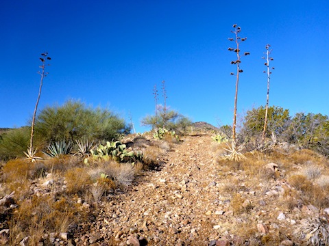
Without any extras, summiting Scott Mountain is straight forward: Head out the back of the trailhead, across a small wash, and pick up an unnamed, unnumbered, jeep trail. The jeep trail climbs 600 AEG the first mile, 400 AEG the second mile, and 700 AEG the final mile (including the 300 AEG, quarter mile bushwhack to Scott Mountain’s summit).
The jeep trail can be driven, but it requires a high clearance 4×4 and driver skill. It is extremely rocky, mostly baseball and softball size rocks, with some small ledges. The steepest parts are also the rockiest. Hiking the jeep trail was like hiking in a typical Arizona wash. Usually, I refer to rocks in that size range as “ankle breakers“, because of their tendency to roll the feet sideways, but the rocks on the jeep trail were mostly flatter, so while I still took care with my footing, it was not too bad.
Normally, I like to hike for a relatively level mile or two, to warm up my legs, before the climbing begins. Hiking Scott Mountain, it begins right away. Though 600 AEG in the first mile is only moderately steep — basically the same as hiking North Mountain in Phoenix — because the gain starts right away, it really got my heart pumping. I was about a mile into the hike, when I heard several shots behind me. (On the way out, the sign in log to cross Slash S Ranch had several “pig” [javelina] hunters sign in after me.)
I barely noticed the shallower angle of the 400 AEG second mile. Scott Mountain is visible from the trailhead, and throughout most of the hike. At the end of the second mile, the jeep trail passes the base of Scott’s southeast slope. It does not look far up to the summit, and you may be tempted to have a go. The dense prickly pear patch should dissuade you.
Hydration ought never be an issue on such a short hike, but I always like to check springs, spring boxes, catchment areas (i.e. rain aprons), cattle tanks and other water sources, if only to pass the intel on to other hikers who might be planning to visit the same area.
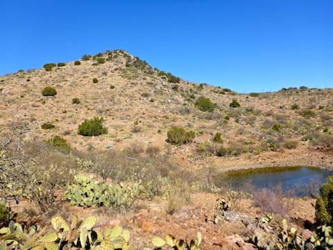
Just over two miles, the topo indicated there was an intermittent tank. Satellite view showed it had water, but Google updates rural sat view even less often than it does in the city. (I remember working in a building in Scottsdale, that satellite showed was under construction, so sat view was about three years out of date.) However, the deeply bowl-shaped tank had a good deal of water in it.
The berm of the tank was about 10 ft. high, and made of loose gravel. Almost like overburden from a mine. As I approached the tank, I had seen a rusty metal object, so I went to check it out.
The object was a heavy metal tray with swinging latches (but no remaining door). A feet away was a section of metal grating. A bit further, I found three parallel metal rails, covered by more metal grating, with a metal box at one end. I thought it might be a sluice, because through the bushes I spotted what looked like a collapsed adit frame. It was not far from the tank, and maybe 20 ft. below it, so I speculated that maybe the tank was created when the mine was blown shut, causing a crater that was eventually filled in with water. Seemed reasonable.
2019-11-20: Turns out, this was the Lead Queen Mine, aka Cocreham Lead Mine: Lead_Queen_Mine_Cocreham_Lead_Mine (pdf datasheet).
Then I noticed a brush screened small slot, a bit further away, and slightly up slope. Curiosity piqued, I ducked under the brush.
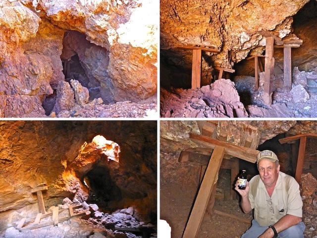
Oh my! The Lead Queen Mine adit was huge. There was no framing at the adit, but plenty of support inside, where there was also quite a bit of collapse. The tunnel was not long, maybe 50 yds., with a smaller adit at the west end. In the middle was a vertical shaft so short I referred to it as a “skylight”. Not expecting to find a mine, I had not brought a headlamp, but due its small size and multiple light sources, the main cavern was negotiable without an additional light source. Videography, though, was problematic, so I flashed my way into a small side stope, that branched several times for 10-20 ft. I found no artifacts or miners’ graffiti.
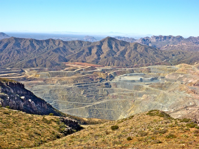
After spending 50 minutes exploring Lead Queen Mine, I got back on the jeep trail. Rather than turning north, along Scott Mountain’s west summit slope, I continued west for a level ⅓ mile, until the jeep trail petered out at the head of Jimmies Luck Gulch, high above Ray Mine. If you don’t like going off trail, or are on this hike just for an elevated view of Ray Mine, that OP is a good spot.
After checking out that view, I backtracked to the intersection, then headed north. In ¼ mile, the jeep trail reaches its high point, before bending to the right. Around that corner, you would have to scale some short vertical wall to summit. Instead, just before the lone tree that marks the bend, turn right (east) and head uphill. It’s steep, and spotted with rocks, cacti and fallen century plants, but the obstacles are easily avoided. Despite having to dodge an angry javelina, I made the summit in 20 minutes.
The Scott Mountain summit is marked by a tall metal pole, painted white and set in cement. The summit is very rocky, and I had to take care with my footing. I was a bit disappointed, as I thought there at least some sort of flat area on top. Camping would be difficult. The views, however, were fantastic.
To the southwest, I could see as far as the Picacho Mountains, 40 miles away. The Catalinas, east of Tucson, were visible 50 miles away. Cake-shaped Picketpost Mountain, only 13 miles northwest, was obvious. In the same direction, 30 miles away, I could make out the Superstition Ridgeline and, just peeking out above some clutter, Weavers Needle. To the northeast, Pinal Peak was so close, it felt like I could reach out and touch it. To the southeast were the Aravaipa Canyon Wilderness and Galiuro Mountains.
Most interesting to me was some large white buildings to the north, seemingly in the middle of nowhere. It didn’t take me long to realize I was looking at the mining operation at Oak Flat, on the top of Apache Leap, above Superior. It’s quite a controversy, so for now Oak Flat is a shaft operation, not yet an open pit like Ray Mine. But you know what? Mines provide jobs and, more importantly, the precious metals that make driving to Scott Mountain possible. (As I pointed out to one irate person in the summit log.)
Speaking of Scott Mountain’s summit log, it was opened in 1991, and mine was the first entry since 2013. After 50 minutes of shooting photos & videos, and reading the summit log, I headed down.
I only stopped once, to swap out water bottles, making the trailhead in an hour and 20 minutes. After rehydrating, and calling my wife, I headed back out Dripping Spring Road. (I had three bar Verizon reception at the intersection of Dripping Spring Road and AZ-77; two bars at the trailhead and on the Scott Mountain summit.)
I had planned to stop at the Ray Mine visitor’s overlook and have a late lunch, but I was running so far behind, I skipped it. After negotiating a traffic jam in Gold Canyon, of all places, there was no way I was going to subject myself to rush hour in Phoenix, so I stopped for 90 minutes at the Subway in Apache Junction. Leaving the Subway at 6:16 p.m., I made it all the way to the intersection of AZ-51 and Glendale Ave. in only 34 minutes; it took me another 15 minutes to drive the last four miles home. I hate Phoenix Asshole Drivers.
Directions: From Phoenix, head east on US-60. In Superior, head south on AZ-177 for 31.6 miles to Hayden. Turn left on AZ-77, towards Globe. Drive through the hamlet of Dripping Spring. At milemark 153.5, turn left onto dirt Dripping Spring Road. It is car drivable in dry. (Though I wouldn’t do it, I saw someone else in a sedan.) Dripping Spring Road is twisty, with steep up & downs, so it would be like ice skating in wet. At 5.1 miles, there is a sign in stand, as you are crossing private property. At 9.3 miles, just before the Slash S Ranch, turn left into the camping area and park.
GPS File: Scott_Mountain
Distance: 7.56 mi.
AEG: 1,887 ft.
Time: 3h 30m
Mine Exploration Video
Hiking Video
Hiking Scott Mountain, Dripping Springs, AZ from Preston McMurry on Vimeo.