

I was thinking of doing this hike back in June, or early July, but for some reason I cannot remember — despite two hours of searching old triplogs — I ditched it in favor of some other hike. Or commitment. Who knows? It’s driving me nuts trying to remember! 🙄
Most people start their hike at the Sandys Canyon Trailhead. But I like doing my own thing, finding my own way & proving things to myself, so I went a different route: I decided instead to start from near the Lake Mary Picnic Area.
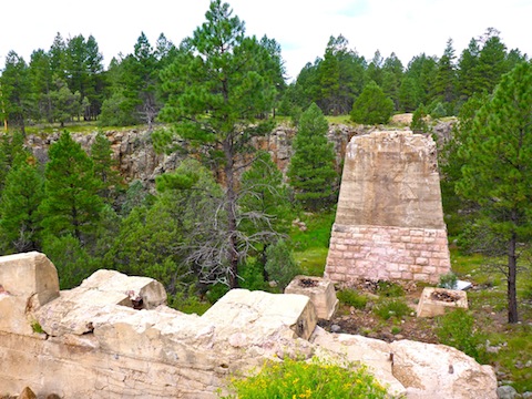
On satellite recon, I had noticed some odd structural bits on Walnut Creek, just north of Lake Mary Rd. To me, they looked like an old, collapsed dam. So, I decided to make that whazzit? my trailhead, hiking an extra mile, each way, more than I would from the official trailhead.
I left home early, and traffic on I-17 was lighter than normal. Maybe because it was Monday? I made good time to FR 9487B, and was hiking by 8:00 a.m.
Someone was trailer camping just past my parking spot, so I gave them a decently wide berth on my way to the whazzit?, which turned out to be the concrete pilings for a rather large old bridge.
I saw no pavement remains on FR 9487B, nothing was obvious on satellite recon, and I could find nothing on google. Maybe a very old alignment of Lake Mary Rd.? Let me know if you have an info on the bridge!
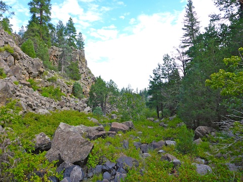
From the old bridge, I descended to Walnut Creek. It was relatively easy going: The creek flowing underground, evidencing itself mostly as seeps, in thickets of wet grass, with some small rocks. Then things changed.
The rocks got larger, require much greater care with footing. Footing made all the more problematic by an exponential increase in vegetation, nearly all of the trippy variety: The wait-a-minute vines were dense, often waist deep, and with little barbs along the leaf edges. Not enough to stab you, but enough to catch on clothing. Even if your feet don’t get caught in something, wait-a-minute vines dragging on your clothing, arms or hiking poles can be enough to throw one off balance. One of my two falls happened that way.
I was also concerned about encountering poison ivy, poison oak or poison sumac. I have no idea what any of them look like, but it sure seemed like the place they would lie in wait.
Three quarters of a mile into my hike, I came to a small dry fall. It was not high, but it was high enough a middle aged fat man should avoid climbing down. I managed to find a half decent bypass to the west.
Not too long after that, I fell flat on my back when my foot lost grip on a slanted boulder. No harm, no foul — I guess — but I was getting fed up with the bushwhacking. Due to the rocks & wait-a-minute vines, I was only making 1.0 mph.
A mile and half into my hike, I found a trail. I first followed it west, where it started up Sandys Canyon’s bluff. I thought it went to the Sandys Canyon Trailhead, but also thought it odd there was no established trail heading from there, north along Walnut Creek. (Turns out, I was on the trail from the Canyon Vista Campground to ‘The Pit’ climbing area.)
I didn’t want to go to the campground, so I returned to Walnut Creek, and followed the trail up the east bluff. The trail got narrow, along pebbled ledges. I knew that was not Sandys Canyon Trail! But I also had no desire to do more bushwhacking, so I picked my way along, eventually finding a crack in the rock that while steep, was not vertical. Maybe a high Class 2.
At the top, I found Arizona Trail Passage #31, which I followed north for a couple hundred yards, until it started switchbacking back to the floor of Sandys Canyon. Right before the AZT starts switchbacking, there is a fantastic view of the San Francisco Peaks.
Three miles into my hike, I finally hooked up with Sandys Canyon Trail #137. Or 1.25 miles from the Sandys Canyon Trailhead, if you took the much easier trail route. Note that my bushwhack, the trail from Canyon Vista Campground to ‘The Pit’, and the full, proper, Sandys Canyon Trail are included in the attached GPS file, below.
Sandys Canyon Trail #137 was as nice as could be. Unless you really enjoy bushwhacking and mosquitoes — I got eaten alive! — avoid the route I took. The trail is smooth, through a wide grassy area, with regular shade spots, with decent sitting rocks, and photogenic rocky bluffs on all sides.
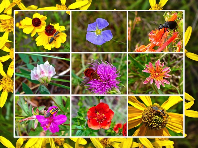
There were flowers of dozens of varieties everywhere. However, most of the flowers were small, and the patches normally not very large, so the color was not dense, but more dappled. Lots of bugs were chowing down on petals and other flower parts. I saw a couple making baby bugs. 😍
I took a break at the triangle intersection where the Arizona Trail Passage #33 splits back off Sandy Canyon Trail, heading up Skunk Canyon towards the middle of Flagstaff. Arizona Trail Passage #31, meanwhile, curls up a small, unnamed canyon, to the top of Fisher Point, then towards Walnut Canyon National Monument, before eventually looping around the east end of Flagstaff.
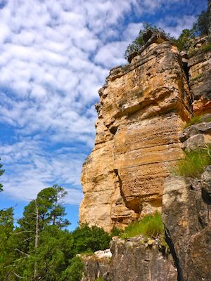
I thought about heading up to the top of Fisher Point, but after the bushwhack, I just wasn’t feeling it, instead settling for taking numerous pictures of its spectacular rock formations.
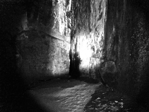
Instead, I continued about a half mile north up the west end of Walnut Canyon to a cave I had heard about.
You’ve heard of ‘slot canyons’, right? Well, this was a slot cave. Narrow, high-ceilinged and deep. At the main entrance, there is a decent sized alcove decorated with graffiti, no doubt by NAU students. From the alcove, the cave gets narrow, but easily navigable. It is much cooler than outdoors, causing the walls to be wet, and slimy, with condensation. 130 ft. in, there is a cavern. To the left is small passage to the outside. (I could see sunlight at the other end.) I could have low-crawled that. Heck, I made it in smaller holes when I explored Webber Mine.
Directly across the cavern from the main passage, is an even narrower passage. Six inches wide, at most. Even narrower than Fat Man’s Pass on South Mountain. Deeper too. I tried squeezing in. Despite turning sideways, I barely fit. No way could I have got past the opening without getting stuck. But then I am 40 lbs. overweight. Have any of you anorexic folks been back in there?
There was enough light to see much of the way into the cave, but not nearly enough to film past the first 30 ft. or so. I had brought a new flashlight with me, after my headlamp & previous flashlight proved so inadequate while exploring Hargan Mine. I was disappointed the flashlight was no brighter. At least it gave the video a spooky, Blair-Witch vibe. 👀
After checking out the slot cave, I headed back south on Sandys Canyon Trail #137. When I got to where AZT #31 splits off to Marshall Lake (where I came from after my cliff climb), I instead stayed on Trail #137 towards the Sandys Canyon Trailhead. From the trailhead, I followed the power line southeast, basically paralleling Lake Mary Rd. back to my start point on FR 9487B.
Sandys Canyon Trailhead Directions: Easy enough to figure out: From Phoenix, head north on I-17 almost all the way to Flagstaff. When you see the signs for I-40 east, stay right. Take the Lake Mary Rd. exit, which is just before I-40. In about 4.6 miles, as you round a right hand curve, turn left onto a dirt road. If you turn into the horse properties, you turned to soon. If you pass the Lake Mary Country Store, go back. On the dirt road, take the first right, parking at the end of the dirt road in .25 miles.
Old Bridge Trailhead Directions: Continue east on Lake Mary Rd. A quarter mile past the Lake Mary Country Store, opposite the entrance to the Lake Mary Picnic Area, turn north onto FR 9487B. It’s rough, and cut up with mud ruts. Continue as far as you are comfortable. I went .25 miles; at .40 miles, just before the old bridge, is a camping area. Do not attempt this in a car! If you have a car, park at the picnic area, then walk up FR 9487B.
GPS File: Sandys_Canyon
Distance: 9.39 mi.
AEG: 592 ft.
Time: 3h 54m
Hiking Videos
Exploring Walnut Canyon Cave, Arizona from Preston McMurry on Vimeo.