

It’s been five months since Paul (‘PrescottStyle’) and I last did a hike together, to the Granite Mountain Hotshots Memorial State Park, south of Yarnell.
After last weekend’s brief 75° respite, when I hiked Charles M. Christiansen Trail #100 end-to-end, Phoenix’s high temp shot back through the roof, maxing out near a hundred. (Which, I guess, is rather mild compared to the 120° it will be in another six weeks.)
Where I normally plan like most folks breathe, I put today’s excursion in PrescottStyle‘s hands. All I knew was we would be starting from his ranch in Deering Park, just west of Thumb Butte, with a possible destination of Sugarloaf Mountain.
Sugarloaf is one of a series of hilltops that form the main ridge of the Sierra Prieta, including West Spruce Mountain, Williams Peak and Porter Mountain. The Sierra Prieta separates Deering Park from Copper Basin. From Deering Park, the Sierra Prieta has a prominence of about 800 ft., while it is 1,500 ft. above Copper Canyon.
Other major Sierra Prieta formations, which are not part of the ridge, include Thumb Butte, Granite Mountain and Little Granite Mountain.
We headed down a gravel road, past the spread of an old cowboy who played the wagon driver in Johnny Depp’s crappy “Lone Ranger” remake, then headed up a pleasant, but unmarked trail.
We joined Sierra Prieta Trail #264, near the second gate, where a branch trail heads down to Copper Basin. We headed west on Trail #264, continuing to climb, until we reached the West Spruce Pack Trail.
Paul and I stopped to discuss if we should continue past West Spruce Mountain, to Sugarloaf Mountain, or summit — such as it is — Porter Mountain, then do some mine exploring. As the summit of Sugarloaf is well below the summit of West Spruce, actually necessitating a climb up from the summit, at least from the east, we opted for Porter Mountain.
Note that the topographic map has two features labelled “Porter Mountain”: The first, at Williams Peak, is the Porter Mountain Benchmark; the second, two miles northwest, is actually Porter Mountain. We were by the actual mountain. 🙄
We headed down the pack trail for a few hundred yards, before turning up towards the Porter Mountain summit, all of 150 ft. above us. 💪
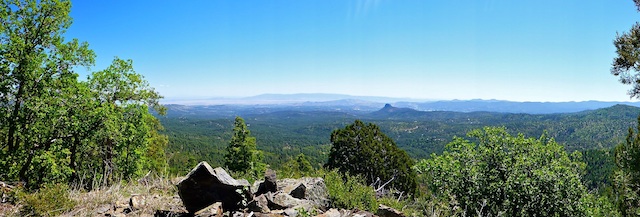
Paul tells me Porter Mountain is the most visible summit of the Sierra Prieta ridge, from Prescott, but it is not prominent enough to warrant a summit register, nor a geocache. Nice view though. 🙂
Then we headed down the east slope, bushwhacking our way towards Sunrise Mine.
Sunrise Mine was not very large, just four known adits, of which three were dynamited in the 1970s when authorities discovered wildcatters mining for silver & gold.
Paul showed me the fourth adit. The untimbered opening was small, but surrounded by loose dirt and fractured rock. He said had been in there a few weeks ago, and the tunnel only went back 75 ft. and there were no artifacts, other than a pickaxe he had removed. I figured for no payoff, why risk it?
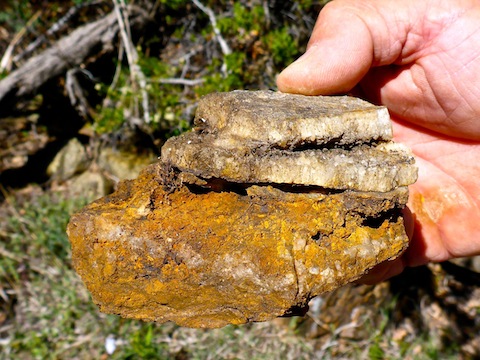
We found many rocks with tiny crystals and interesting mineralization. The most fascinating specimen featured five distinct layers, with thin gaps between several, where the wildcatters had leached trace gold & silver.
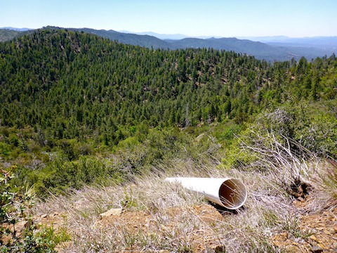
Some pretty large PVC pipe ran downhill from one of the dynamited adits. Paul thinks it was used as sluice / ore chute, as something that large isn’t typically used to drain mine water. There pipe is a couple hundred feet long.
Now on an old mining road, at the bottom of the pipe we found a few scattered artifacts … okay, junk … typical of an abandoned mining camp: a 40 gallon barrel, a bed spring, etc. The most interesting artifact was a steel I-beam with old & rotten wood bolted to one side. It was way too big to be an ore cart rail. Check out the video and let me know what you think it might have been used for.
Then we headed up a wash with some more blowdowns. Paul throught it was quite congested, but I told him it was nothing compared to the obstacle course that is East Miller Canyon, on the Mogollon Rim. Since one blown down Douglas fir or ponderosa pine looks the same as another, we turned around, instead heading down canyon, back to Deering Park.
After a few post hike brews at Paul’s ranch, my wife & I took AZ-89 home. We picked up dinner at the always awesome T-Bird Cafe in Peeples Valley, then stopped for a few minutes at the Granite Mountain Hotshots memorial south of Yarnell.
Directions: From Courthouse Square in Prescott, head west on Gurley St. Stay on Gurley as it becomes Thumb Butte Rd, gettingnarrow and twisty. In a little over five miles, turn onto the first dirt road on your left, FR 373. Follow FR 373, as it ascends, for about 3.5 miles. When Copper Basin opens up before you, park. That is the Sierra Prieta Trail #264 trailhead.
GPS File: Porter_Mountain_Sunrise_Mine
Distance: 7.25 mi. / 5.71 mi.
AEG: 1,600 ft. / 1,310 ft.
Time: 4h 00m / 2h 54m
Mine Exploration Video
Porter Mountain / Sunrise Mine from Preston McMurry on Vimeo.
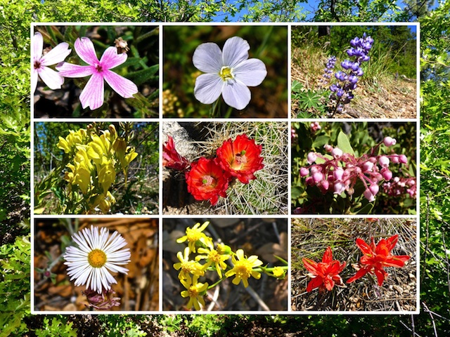
Interesting hike and the flowers are lovely.