

The first stop on this year’s Arizona fall color tour was Lockett Meadow to Inner Basin in the San Francisco Peaks. The second stop, last week, was supposed to be a trip to the Mogollon Rim, but work on my house ran into Friday, and I thought it best to stick around Kingsnake’s Home Den.
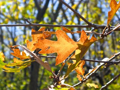
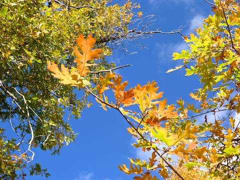
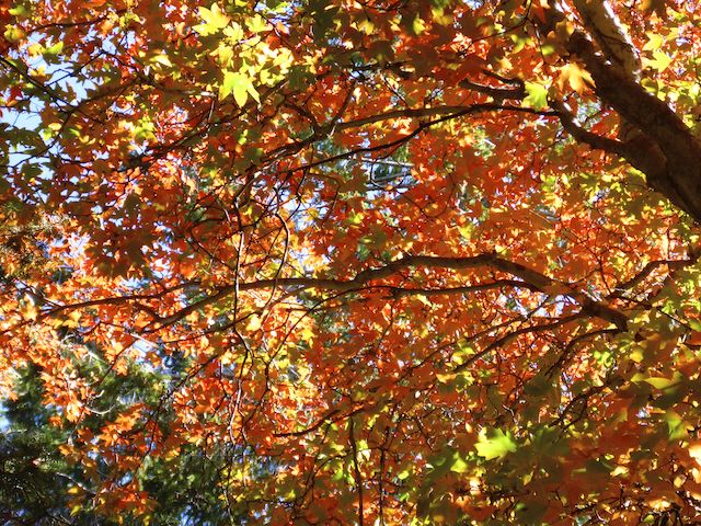
This week it was out to Pinal Peak in the eponymous Pinal Mountains south of Globe. Pinal Peak usually has good fall color the third week of October, including not just the yellows of quaking aspen, but also the oranges and reds of Gambel oak and bigtooth maple. Especially the latter two species. 🍁
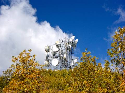
There are several options for summiting Pinal Peak, the easiest of which is to literally drive straight to the top via easily car drivable FR 651. I didn’t see any gates on my hike, not even around the multiple antenna farms, so for the less physically inclined, go for it. The views are incredible.
Ironically, 7848 ft. Pinal Peak is the mountain with the vast majority of the antennas, while adjacent 7812 ft. Signal Peak has just one.
If you are more inclined to a bit of moderate exercise, drive up FR 651 to the Pinal Campground, located between the summits of Pinal Peak and Signal Peak, near the junction of FR 651C. From there, a number of small loops can be constructed of Pipeline Trail #193, Middle Trail #202, Ferndell Trail #204 and various spur jeep trails off FR 651. (Pick up a full color Pinal Peak trail map at the Globe Ranger Station on 6 Shooter Canyon Rd., just past the turn off onto Ice House Canyon Rd.) Putting them all together would still be only 2.5 miles and 400 ft. accumulated elevation gain (AEG). 🗺
I’m not a trail beast, but I chose instead to earn my Pinal Peak summit by hiking up Pioneer Trail #196 from Pioneer Pass on FR 112. From Pioneer Pass, summiting Pinal Peak, is a 5.0 mile round trip, with 1,700 ft. AEG.
But because my wife accompanies me on my trips — if not the actual hikes — I parked a mile back down FR 112, at the Pioneer Pass Campground, where there are pit toilets. I sure needed one after the chorizo I ate for breakfast!
If you hike from Pioneer Pass Campground, rather than Pioneer Pass itself, add 2.0 miles and 400 AEG roundtrip to the distance.
There’s room at Pioneer Pass for a couple of vehicles, but I’ve never actually seen anybody parked there. East Mountain Trail #214 is to the left (east), Pioneer Trail #196 to the right (west).
From FR 112, Pioneer Trail #196 immediately starts climbing. If you look at the elevation profile in the GPS file (attached below), it looks like a steady climb the whole way to the summit of Pinal Peak: 650 ft. the first mile, 750 ft. the second mile and 300 ft. in the final half mile. I consider that at the low end of steep, or the high end of moderate. Basically, like doing North Mountain two-and-a-half times in a row, but with much nicer surroundings, and absolutely no human traffic (foot, MTB or horse). 😅
Pinal Peak from Pioneer Pass is such a steady climb, that there is only 20 ft. of AEG on the way back down. Margin of error on GPS satellite drift could easily account for that small an amount. By way of contrast, Cottonwood Trail #120, in the Superstition Mountains, has 1800 ft. AEG on the way up, but a more normal 300 ft. AEG on the way down, because trails typically go up & down in different sections.
Despite the apparently continuous climb, there are actually flat, or low angle, sections on Pioneer Trail #196, so that I could catch a breath. Otherwise, I took it slow & steady. The steepest parts felt like the first ¼ mile up from Pioneer Pass, and Ferndell Trail #204, which climbs 300 ft. in ¾ of a mile. Or it could have been that I was just tired by the time I got to Ferndell Trail? 🤔
I actually felt good both at the summit of Pinal Peak and back at Pioneer Pass Campground, after hiking 10 miles. (Though I was definitely hurting on Saturday & Sunday.)
That describes the trails, but what about the fall color and the scenery? 🏞
There are really nice vistas available on Pioneer Trail #196 at 0.7 and 1.2 miles up from Pioneer Pass. The best view is from the latter, which is 300 ft. higher. Both vistas have southeasterly views, across El Capitan Canyon towards the Mescal Mountains and the San Carlos Apache Reservation. In between the two vistas, there are some log stairs that appear to be more for erosion control than fat guy relief.
The first fall color, a few small Gambel oak, were only a ⅓ of a mile up Pioneer Trail #196; the first red leaves of bigfoot maple occured just after the second vista. From the second vista all the way to FR 651, the oranges and reds were pretty steady, but not especially dense.
Two miles up Pioneer Trail #196, on the right side of the trail, is an absolutely massive tree. It’s not an alligator juniper, like the Granite Mountain Hotshots saved, but I’m not sure what exact species of pine tree it was. In any case, the base of the trunk was 4½ feet in diameter. Easily twice as thick as any other tree I saw. 😳
A few hundred yards past he massive pine, Pioneer Trail #196 splits: Left to continue to the Pinal Peak summit, right to Squaw Spring. (The spring has not been renamed as the former Squaw Spring Trail #196 was.) The spring is fenced, but what looks like a lock is just a wrapped chain. But a summit hike is short enough you shouldn’t need to filter any water: I only drank half my 3.7 liters of fluids.
150 yds. past the spring, just before FR 651, is the only gate on Pioneer Trail #196.
Supposedly, there are 32 antennae scattered over Pinal Peak, but I only checked out the ones actually on the summit. Even better views than on the summit can be had on FR 651, sixty feet below the summit. I could see the entire Dripping Spring Mountains, including Scott Mountain. I could see Asarco’s massive Ray Mine, peeking out from behind the Dripping Spring Mountains and, beyond the copper pit, Granite Mountain (there are many of the them in Arizona), Battle Axe Butte, Teapot Mountain, the White Canyon Wilderness and, north of that, Picketpost Mountain. I could even see Mount Lemmon!
After checking out the views, I followed FR 651 through a small cabin community to Pinal Campground. I was hoping the cabins were being rented by the Forest Service, but no such luck: They are privately owned. 😕
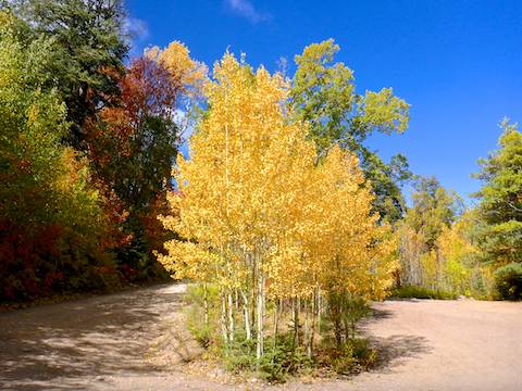
The best fall color of all, was along FR 651C, to the junction with Six Shooter Trail #197, then up Ferndell Trail #204. Just amazing.
Other than a 20 minute lunch break halfway down, I booked the 3.5 miles back to Pioneer Pass Campground in only 80 minutes.
Great hike!
Directions: From Mesa, head east on US-60 through Gold Canyon, Superior, Miami and Claypool. In Globe, turn right on Hill St. (the first road after crossing the bridge over the railroad culvert). At the bottom of Hill St., turn right on Broad St., then make an immediate left onto Ruiz Canyon Rd., then another quick left onto Jesse Hayes Rd. at Connie’s Store. In 0.9 miles, split right onto Ice House Canyon Rd. In 3.7 miles, Ice House Canyon Rd. changes from pavement to dirt. FR 112 is car drivable, but is narrow and very, very twisty, often with unrailed steep dropoffs. Keep your speed at 10-15 mph. Pioneer Pass Campground is spread along FR 112 beginning at 5.3 dirt miles. Park at any camp site, or continue to Pioneer Pass and park there.
GPS File: Pinal_Peak_fm_Pioneer_Pass_Campground
Distance: 9.97 miles
AEG: 2,462 ft.
Time: 4h 08m
Hiking Video
Hiking Pinal Peak: Fall Color! from Preston McMurry on Vimeo.