
")
My mine exploring buddy Paul, aka @PrescottStyle, had this up for last Saturday, but William couldn’t make it, and I knew Sunday would be too damn hot. Indeed, my backyard on Sunday was 122.8° F / 50.4° C, while Monday was “only” 120°.
William has a claim in the area, and he wanted to locate the vein within the claim. Paul had forwarded me the claim number, which I looked up on the Yavapai County GIS (geographic information system). Unfortunately, while the boundary of William’s claim is mapped, the lat / long of the corners were not precisely provided. So, I resorted to hovering my mouse over each corner, then using the XY tool to reveal the numbers. I wrote down all the pairs. Then I went to HikeArizona.com, inputting those same numbers into MapDex, laying a waypoint for each pair. I figure with satellite wiggle, when we eventually stood upon the ground, we could be +/- 20 feet.
I also marked some other nearby mines for possible exploring, time permitting. One of those mines was the Mount Union Mine.
We met up in downtown Prescott, before heading south down Mount Vernon Ave., which turns into the Senator Highway as it leaves Prescott. The pavement turns to decent dirt just past the Camp Wamatochick TH, which is shared by both the Wolf Creek Loop Trail #384 and Groom Creek Loop Trail #307, which summits Spruce Mountain. As the Senator Highway approaches the bottom of Mount Tritle, it gets very twisty, and somewhat rougher. On the east slope of Mount Tritle, the Senator Highway continues south towards Crown King. Driving to Crown King should only be attempted by high clearance 4x4s. According to William, the descent to Venezia is particularly rocky.
Instead, we continued east on FR 261, aka Poland Road, which passes through Five Corners on its way to AZ-69. The 1.5 mi. section between the Senator Highway and our trailhead at the top of FR 9403G is drivable by a stock street SUV. (We passed several on our way back into town.) I’m not sure I’d continue on FR 261 to Five Corners, but the section from Five Corners to AZ-69, despite still being dirt, is smooth as glass.
There is a slight climb, to the ruins of an old a-frame, at the beginning of the hike. Paul, William and I poked around for a bit. When I went to take some pictures, my camera would not turn on. ![]() Okay, sometimes it does that, but I am okay if I hold the power button for a few seconds. Nope.
Okay, sometimes it does that, but I am okay if I hold the power button for a few seconds. Nope. ![]() Okay, check to make sure the battery is properly seated. There is no battery.
Okay, check to make sure the battery is properly seated. There is no battery. ![]() Have to settle for using camera on mobile. Mobile nowhere to be found.
Have to settle for using camera on mobile. Mobile nowhere to be found. ![]()
Cork blown, thinking I may have left my mobile in my wife’s car or, God forbid, dropped it in Courthouse Square, I try calling my wife with Paul’s phone, but couldn’t get ahold of her. I was in full melt down. Paul suggested checking William’s truck, as “sometimes things fall out of your pocket in it”. Back to the trailhead we trudged. I could not find my mobile in the truck. Well, fuck me. That kind of defeats my purpose for being there. I told Paul & William I’d still go along, to help with mapping the claim, but I was screwed. Until … Paul called me and I heard my mobile ring. It was down in a seat cushion. Finally, I could function.
Back up to the a-frame we went, then down the other side towards Mount Union Mine.
As you head south on FR 9403G, the jeep trail becomes undrivable, but easily walkable. It has been at least 50 years since it’s seen wheeled traffic, as there are tall manzanite growing in the middle of the road. William pointed out the stacked stone retaining walls, and dirt fill, the miners used to create the original road. (Though the walls were not in nearly as good a condition as on Rock Wall Trail #608, near Strawberry.)
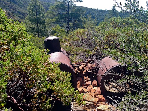
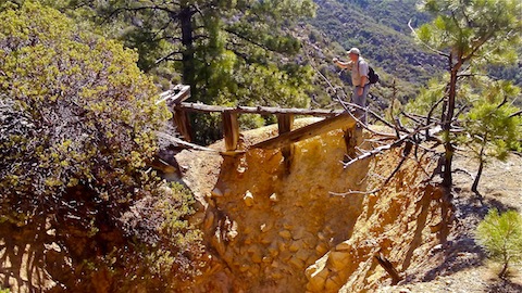
The first part of the mine you will see, just off trail to the east, is a boiler. One piece of the boiler had a very pretty, decorative, but functional, flu control. Working your way through a gap in the bushes is the assay office, of which nothing remains but some shattered crucibles and bottles. On one side of the assay office is a 200 ft. tailings pile. On the other side is the main shaft. According to William’s miners’ map, it is 600 ft. deep, with tunnels at each 100 foot drift level. According to mindat.org, the shaft is 800 ft. Either way, it is so wide I could not fit the opening in frame for a photo. William marvelled at the quality of the riveting on a collapsed water tank. For some reason, we forgot to check out the remains of the mill, which we could see slightly down hill.
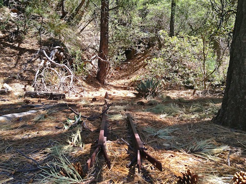
Instead, we found an old foot trail, using that safely bypass the tailings pile, at the bottom of which we found an adit accessing the 200 ft. drift level. The opening is indicated both on the topo and the miners’ map. There is an ore cart track leading into the adit, but it stops there. I thought the splits at the outside end were a track switch, but William said the splits were actually how the miner’s would splice in the next track segment. The adit is kind of ragged, but fairly open. Paul and I crawled in about 20 ft. There is a very impressive stope, which is also on the miners’ map, but the rest of the tunnel was collapsed. There was no framing at all, other than one log across the middle of the stope.
We had a lunch break. Paul & William had sandwiches, but I had forgotten that as well. And the salt restoring chips I nibble on throughout a hike. Worse yet, I had left my gorp in the fridge at home. And the backup baggy of energy bars. I was having a thoroughly awful day. ![]()
After the adit, we battered our way across the rocks and dense brush of a nearby spur. Only two miles into the day, and I was toast. (Figuratively and, as I would later discover in the shower, literally.) Honestly, I was a bit worried I had gone too far. I blame a combination of being fat, old, unacclimated to 7000 ft. altitude, beating brush (which is more physical than it appears), lack of nutrient replacement, and stress from forgetting pretty much everything except my name.
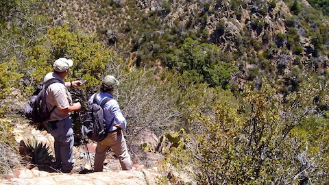
We had arrived near one corner of William’s claim. The actual point was maybe 50 yds. away, but was down a steep slope. I pointed out a tree that should be within a few feet of the corner and, a couple of hundred yards away, an outcropping that should be near the next nearest corner. It was already 11:45, so even if I had been in condition to continue, climbing down to the actual point, then over to the adjacent point, then making our way back, would have added several hours to our day. Instead, we began our return.
I felt bad, for letting Paul and William down, but this was their third trip to the claim, and the first to successfully locate a corner. (Their previous trip was a good 1/4 mile off, and two spurs over.) So, we accomplished something.
Next time, instead of beating brush, I hope to head straight down FR 9403G to the mine’s 600 ft. level, where there should be another adit.
On the way back up FR 9403G, I was definitely taking my time. We took several sit down breaks, some at my behest, some at Paul & William’s. ![]()
After we finished, we met up with my wife, stopped at a grocery store for supplies, then ended the day at William’s ranch near Thumb Butte. Bernie loved petting his horses, and I shared some of my roast beef rollups with his dogs Hunter and Bobo. (A chihuahua who’s schlong was so huge, if he’d been human, it would have been dragging the ground. ![]() )
)
Distance: 3.44 mi.
AEG: 863 ft.
Time: 2h 18m
Mine Exploration Video
Exploring Mount Union Mine, Yavapai County from Preston McMurry on Vimeo.