Kelly dropped by Casa Kingsnake after her shift, and we drove up with my wife to Prescott. I-17 did not have much traffic on it for 7:00 a.m.; seemed like less than a weekday at 6:00 a.m. Oh, if that had lasted …
I drove down the Senator Highway, which was paved to just past the Groom Creek trailhead. FR 79 was a car-drivable road. 79A was AWD SUV-able. About .3 miles up there was nice pullout, where we parked.
Kelly and I started up Trail #65, while my wife did puzzles and read a book at the trailhead. (She can’t hike, really, but she comes along to enjoy whatever natural wonders are available at trailheads.) The first half mile was a nice stroll, on good trail, but the next mile up to the saddle was rocky, slippery and very steep. Despite doing well last week on Mount Davis & Mount Union, I was sucking wind, and had to stop several times for 30 second breathers. Also, it was 90° with no breeze. ![]()
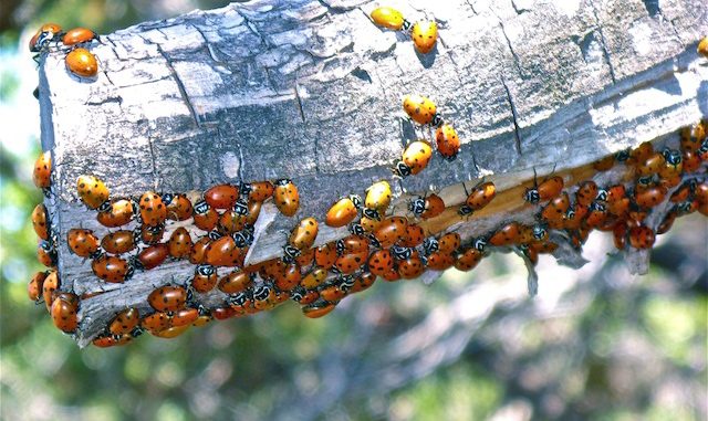
At the saddle there was a great view of Dosoris Canyon (south of Tritle and Maverick). We thought of following the blazes up Maverick’s east spur, but opted instead for going up a wash on its south slope. The wash was relatively brush free — unlike the spur — but was steeper. By the time we got to the top, I was zapped. We couldn’t find a Maverick summit log, but did find a boat load of ladybugs. ![]()

After a brief rest, we started down the ribboned spur, but brush had us edging into another wash. After we got down, we returned to the saddle, and began east towards Mount Tritle.
In a half mile we came to an even steeper and rockier climb towards Tritle. I was done. I encouraged Kelly to continue on, while I settled for eating lunch and looking for photo ops. I saw two fist-size yellow butterflies — no pic! ![]() — and an eagle. It was turkey vulture sized, but obviously not a vulture, and definitely too big for a hawk or falcon. Also not bald eagle colored. It was brownish white. By the time I got my camera out and powered up, he was above the branches, and thus no pic either.
— and an eagle. It was turkey vulture sized, but obviously not a vulture, and definitely too big for a hawk or falcon. Also not bald eagle colored. It was brownish white. By the time I got my camera out and powered up, he was above the branches, and thus no pic either. ![]()
Thankfully the breeze picked up while Kelly was gone.
After she got back, we booked back to the trailhead, slipping several times going down Trail #65. I had some Stella on ice, but considering the several times I felt light-headed on the hike, decided discretion was the better part of valor. ![]()
Driving back down I-17 was so traffic strewn and stressful — dead stop? SERIOUSLY!? ![]() — that we stopped for a break at Sunset Point. It did little good. I was ready to go Falling Down, so we got off at New River, and took the frontage road and Cave Creek Rd. home, as I’d rather drive a consistent 35, 45 or whatever than herky-jerking from 65 to 35 to 80 to 0 on a freeway. Plus, that’s not safe. The side route was much more mellow, and I arrived home with my blood pressure restored.
— that we stopped for a break at Sunset Point. It did little good. I was ready to go Falling Down, so we got off at New River, and took the frontage road and Cave Creek Rd. home, as I’d rather drive a consistent 35, 45 or whatever than herky-jerking from 65 to 35 to 80 to 0 on a freeway. Plus, that’s not safe. The side route was much more mellow, and I arrived home with my blood pressure restored. ![]()
Directions: From From Gurley St. in Prescott, head south on Mt. Vernon Ave., which becomes the Senator Highway. In 7.4 miles, just after the pavement ends, turn right onto the second dirt road, FR 79 / Kendall Camp Rd. Make a quick right & left to cross the Hassayampa River. Depending on surface conditions & water level, a car could handle FR 79. In 1.8 miles, FR 79A splits right. I parked my SUV a ½ mile down FR 79A.
GPS File: Mount_Tritle
Distance: 5.78 mi.
AEG: 1,488 ft.
Time: 2h 33m
