

Despite being slightly ahead of the curve for my 50 monthly miles, this week I was looking for a longer hike in a cooler clime. Hiking Arizona Trail segment #29, just west of Mormon Lake in the Coconino National Forest, is what I came up with.
The Coconino National Forest is under Stage II fire restrictions — no campfires or smoking in the open — but I was unaffected as I neither camp nor smoke. While I was doing the hike, the Forest Service actually closed several areas in the CNF, including Mormon Mountain, the east slope of which AZT #29 passes through, and the Mogollon Rim between the escarpment and AZ-260 / AZ-87. (Where I hiked General Springs Canyon and Fred Haught Canyon last week.) 🚫🔥
Rather than take AZ-87 through the Payson traffic jam, then get stuck behind slow people on the two lanes north of Pine and Strawberry, I followed Google Maps’ recommendation to take I-17 north, then cut across on Stoneman Lake Rd. / FR 213. Rather than taking nearly three hours, I made it to the Arizona Trail’s Allan Lake trailhead in one hour, 45 minutes!
Driving Stoneman Lake Rd. / FR 213
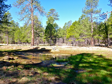
Allan Lake is a dry lake, at the edge of which is Allan Lake Tank. I had 14+ miles to hike, so I didn’t check to see if the tank had water, or explore the small lake’s bed. (On satellite view, Allan Lake looks like a crop circle.)
Throughout it’s length, Arizona Trail #29 switches many times between single track and forest road. After crossing the Allan Lake prairie, it is even rail trail for a mile, on an elevated bed. For the most part, footing was not an issue, and I could concentrate on searching for #flowerporn.
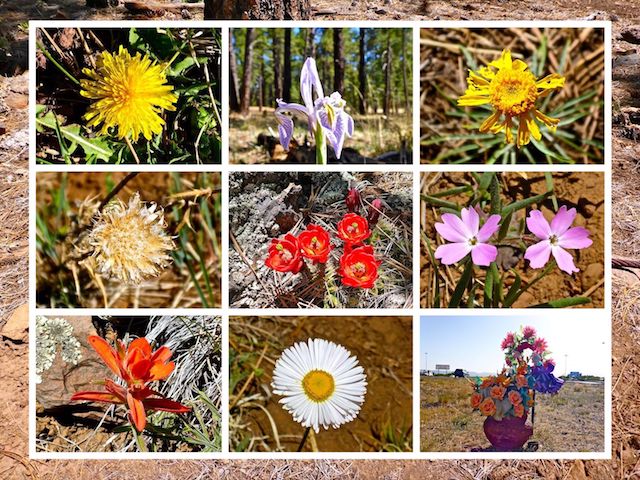
Overall, there were not many flowers on Arizona Trail #29. The southern third of the hike, was almost all dandelions. The middle third there were a few more species, but still mostly yellow flowers. The northern third had the most variety, with some brilliant claret cup and a huge patch of spreadfruit goldenbanner. It was enough to satisfy my lust. 💐😍
There are small prairies throughout the hike, but there is always plenty of shade. Most of trees are ponderosa pine, with gambel oak and other deciduous species dominating around Mount Nestor. There is almost zero undergrowth: The only grab & stabs I saw, besides a few small cacti, was about a 200 yard wide patch on Mount Nestor’s north slope. Those were tall, brittle, vines with rose bush-type thorns, rather than catclaw. Take care to avoid involuntary blood donation, as the AZT passes right through the middle of the patch.
As it proceeds west of Mormon Lake, Arizona Trail #29 is always well-defined. I only needed my GPS to record a track for this blog. If you are ever in doubt what direction to go next, there are plenty of AZT signs to show you the way. Cairns can be a useful tool, but here they are totally unnecessary. It appears a particularly strong microburst may have blown a few of them over. 😇
The only critters I saw were a few lizards that moved before I could take their picture. I’m still amazed that horney toad posed for me on Los Burros in 2012. There were lots of birds chirping in the trees, but with a crappy camera and miles to grind, I did not have the time or equipment to attempt a photo. I saw no bigger critters, like elk or deer, but their scat was everywhere.
I took my first break near Airplane Tank. Besides my usual salt & vinegar chips, I snacked on some Planter’s Turtle Sundae Mix — delicious gorp with a good balance of pecans and candied peanuts.
There’s springs and tanks all along Arizona Trail #29, but most are a couple hundred yards east or west. I can’t attest to most of their water level or quality. Van Deren Tank did have water, but was well down, as was an icky unnamed tank in Fulton Canyon. 🤢
I did not drink much water, so I did not need to refill. But at Double Springs Campground there was a tap running out of the ground. There was no “non-potable” sign, so I figured what the heck and opened the spigot. I was expecting clear, cool, tasty well water. Instead, what I got was so cloudy it was gross. I poured the water out. I carry bottles, and had several more waters, a couple of Gatorade G2s, and a trail beer, so I was good.
The fence near FR 219 was bass ackwards: The strands of the gate were plain wire, while the retaining latch loop was barbwire. Yes, I poked myself getting it open. 😕
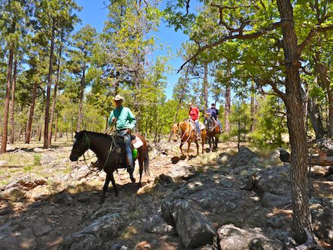
I saw one group of horse riders, another of mountain bikers, and no other hikers.
The intersection with Navajo Spring Trail marks the halfway point of Arizona Trail #29. If you are not doing a key exchange or shuttle hike, you can head back to Allan Lake or Mayflower Spring and get your 15 miles in. Or you can take Navajo Trail 1.1 miles to Mormon Lake Lodge, refuel, have a few beers, then head back. Or, for a shorter key exchange / shuttle hike of roughly 8.5 miles, use the lodge as one of your trailheads. You have options.
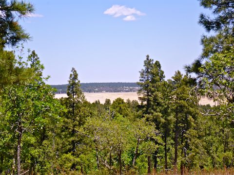
Another option, is the Lakeview Trail, which runs from Double Springs to an spur a half mile and 300 AEG above the Arizona Trail. It would add a small workout to your otherwise low AEG day. (Arizona Trail #29 averages only 70 ft. of gain per mile.) If you don’t add Lakeview Trail, you can still get glimpses of Mormon Lake through the trees as you round Mount Nestor.
I took my second break at Double Springs Campground site #14, which was where I saw all the spreadfruit goldenbanner flowers. Verizon reception at Double Springs was only 0-1 bars. I was barely able to get a text out to my wife, telling her I would soon be at Mayflower Spring for pickup. 📡
From Double Springs Campground, it is 2.7 miles along the lower slope of Mormon Mountain to FR 9481 R, then down the jeep trail to the Mayflower Spring trailhead.
Allan Lake South Trailhead Directions: From Phoenix, head north on I-17 almost to the top of the Mogollon Rim. Take exit 306 onto Stoneman Lake Rd. / FR 213. The first six miles are paved; the final nine miles are car driveable dirt. (This is much quicker than taking AZ-87 through Payson!) At the east end of FR 213, turn left onto Lake Mary Rd. In just under three miles, there will be a small pullout, with an Arizona Trail gate, on the left. Park there.
Mayflower Spring North Trailhead Directions: Whether driving from Phoenix, or Allan Lake, continue north on Lake Mary Rd. for another 11.3 miles to the north end of Mormon Lake. Turn left on Mormon Lake Rd. / FR 90. In 2.9 miles, turn right onto FR 9481R. Park wherever.
GPS File: Mormon_Lake_Arizona_Trail_29
Distance: 15.66 mi.
AEG: 1,074 ft.
Time: 5h 15m
Hiking Video
Hiking Allan Lake to Mormon Lake, AZT from Preston McMurry on Vimeo.