

This was my ninth Loop 202 South Mountain Freeway survey hike. My first survey hike was four years ago, in April, 2015. Hard to believe I’ve been at it that long, or that I had the vision to plan this far out, so that I could effectively document the changes at the west end of South Mountain Park every six months or so.
I actually got the idea a month before that, when I was hiking Alta Trail to the summit of nearby Maricopa Peak, the highest point in the Ma Ha Tuak Range, just south of Phoenix. I looked back west, towards Dusty Lane and the Gila River Indian Community. It was a great view along San Juan Road.
At the time, there was a lot of anti-freeway meetings & talk. The reasons varied: On sacred Indian land, would destroy pristine Sonoran Desert, would cost many people their homes, etc. 🤔
Though routes across the reservation were considered, agreements could not be made with the tribe, so that was out. Instead, the the chosen route was from I-10, west along Pecos Road, to the pump station at 3303 W. Pecos Rd, curving northwest to follow the east side of the power line which is on the reservation’s east border, between the Vee Quiva Casino and Dusty Lane community, across 51st Avenue to Elliott Road, then winding roughly up the same path followed by 59th Avenue, before reconnecting to I-10.
I timed my ninth survey hike to coincide with the first full weekend of the month, as that Saturday and Sunday are the only two days of the month that San Juan Road is open to vehicular traffic. On my first through seventh hikes, I parked in Dusty Lane. By my eighth survey hike, last November, parking in Dusty Lane was no longer practical. The next closest place to park was in Laveen, off Estrella Dr. & 43rd Ave. Parking at the Bajada Trailhead on San Juan Rd. saves me almost two miles of walking. each way.
From Bajada Trailhead, I followed National Trail for ¾ mile to the saddle on Main Ridge North, then cut across country for a few hundred yards to the Graffiti Ranch. 👨🏻🎨
There have been no changes at Graffiti Ranch since last November, either new graffiti or more walls torn down. Or new structures added to what is a pocket of private property at the west end of South Mountain Park.
From Graffiti Ranch, I followed the jeep trail to its neighbor, Rock Wall Ranch.
Which was no more. Gone. The collapsed chicken coop, the foundation, the rock wall, the planter, the random garbage and thousands of nails … all gone. I thought being 100 yds. from the right-of-way Rock Wall Ranch would be safe. Bummer. I’ll miss the rock wall. 😕
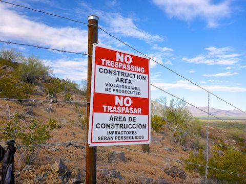
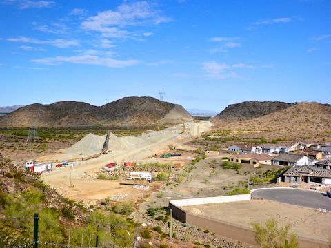
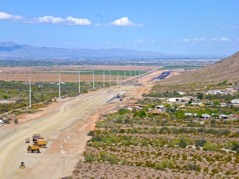
I was hoping one of the multi-use crossings would be complete, so I could legally cross the Loop 202 South Mountain Freeway’s right-of-way, but alas not. So, I worked my way along the yellow “do not cross” rope, between the right of way and the Taylor-Morrison luxury community.
Good thing too! As I was taking pictures from the Wildwood Dr. cul-de-sac, a white pickup drove up from the construction zone. The driver asked what I was up to. “Just taking pictures,” I said. Pointing them out, he replied that they had seen me on three or four security cameras. I mentioned that I had been careful not to cross the yellow rope. And that was that. Because if somebody did cross the yellow rope, that would be a huge safety issue, causing work to shut down, resulting in delays and dollar losses to the project. (Not to mention Federal Pound Me in the Ass Prison for the offender.) 😳
Having reached the north slope of Main Ridge South, the yellow security rope turned to barb wire fence, which I followed up the ridge, topping out at the “The Promontory at Foothills West Summit Collection Community” traffic circle. A number of cyclists and walkers were getting extra exercise heading up from the Pecos Road area.
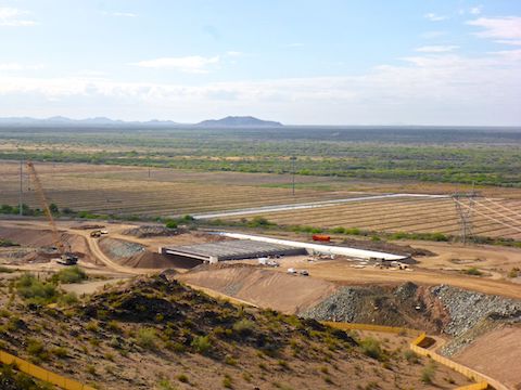
Instead of following the road all the way down, I diverted across a gully to another terrain feature, to get closer, but still high angle, views of the work being done on the Center Segment. I found an amusing barrel cactus, but you’ll have to watch the video, below, to see if you spot it as well. 😉
Working my way south along the wall / fence bordering the still-standing 32nd Lane properties, I arrived near Waypoint #1, at the Pecos Road pump station. Which was missing. I figured the Loop 202 South Mountain Freeway would curve north before it reached the pump station, but I guess it was cheaper to relocate it.
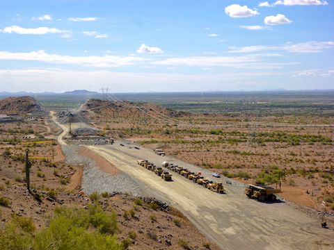
I then backtracked north, along the wall / fence, up 35th. Ave. to the luxury development traffic circle, down Main Ridge South, and across the valley to Main Ridge North. There were a TON of Arizona Blister Beetles near Waypoint #11, the former location of the R.A. Steele Ranch. Between Waypoint #12 and Waypoint #14, there was a parking lot of inactive earth movers.
Back in November, a cut had been blasted in Main Ridge South, but not Main Ridge North, which has since been cut. Still staying clear if the yellow rope, I made my way up the steep slope, which was made more difficult due to not being able to use the old jeep trail that was blasted away.
Waypoint #15 was on top of Main Ridge North. From there, I looked north, across the multi-use crossing #3, adjacent to the pink reservation water tanks, to Dusty Lane. On the far side of the enclave, I could see that pavement had extended south from the Pecos Segment to the foot of Alta Ridge at 51st Ave.
Though from elevated point on Main Ridge North I could get a solid overview of the changes along Dusty Lane, I continued to follow the yellow security rope north, photographing Waypoints #16-20 up close. (Or as close as I could get without trespassing.)
My survey hike complete at Choppo Road and 43rd Ave. (Waypoint #20), I cut cross country, northeast back to my car at the Bajada Trailhead.
The Loop 202 South Mountain Freeway is supposed to be complete in “late 2019”. My next survey hike should be Saturday, December 7. If the Center Segment is not yet open for traffic, I will hike it, otherwise I will drive it. Driving the freeway, showing inset waypoint photos along the way, has always been the intended conclusion to this project. Stay tuned!
GPS File: Loop_202_South_Mountain_Freeway_20190406
Distance: 7.34 mi.
AEG: 853 ft.
Time: 3h 09m
Hike Video
Loop 202 Survey Hike #9 (4/6/19) from Preston McMurry on Vimeo.