

Now that is cool in the Sonoran Desert, I plan to do a few mine explorations. This Friday, I intended to return to Santa Maria River area, hoping to find something even half as cool as the Weepah-Homestake Mine.
But that would have required at least some planning & research, and I had too many other things going on last week to put in the necessary time. I like to have a clue what I am looking at, so I can better appreciate it, then relay that to you, like I did in my Bullard Mine video. ⚒️
In the winter, I’ve also started doing more local hikes, which I hope appeal to Arizona’s winter visitors (aka ‘snowbirds’). So, I was able to quickly change gears to a loop in the Spur Cross Ranch Conservation Area: Spur Cross Trail, Metate Trail, Towhee Trail, Spur Cross Trail (again), Maricopa Trail / FR 48, Limestone Trail #252, Elephant Mountain Trail, Tortuga Loop Trail and Spur Cross Trail (for a third time).
That sounds like a lot of hiking but, other than Limestone Trail #252, the trails were either short — Metate & Towhee — or I was only hiking small bits of them. Check out the Spur Cross trails map.
Although I’ve done the Limestone Trail #252 loop before, it’s been six years. So long ago, I had posted only one video, ever, to Youtube. My videos may not be as slick as some folks, but clearly I’ve come a long way since my first video. This hike is my 448th video! Check it out, below. 📽
When I started hiking at 8:40 a.m., it was 43℉. Good thing I had my hoodie!
From the parking area, head north on the dirt road you drove in on. The fee station is in 200 yds. Sometimes there are friendly volunteers there, collecting. Otherwise, drop your $3 in the box. Don’t cheat: It’s for a good cause, giving us nice places to hike.
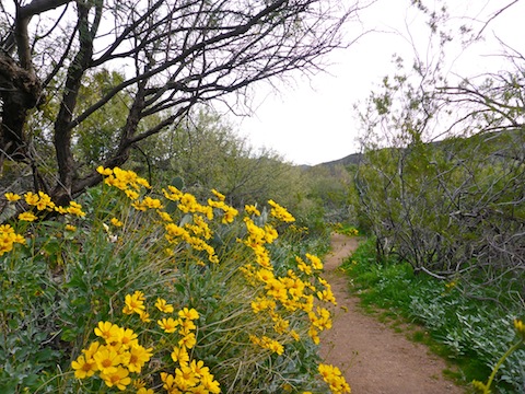
From the fee station, it is 100 yds. north to a picnic area and two massive, wheelchair accessible, porta-potties. I turned left, heading downhill to Cave Creek, which despite being a trickle is crossed by a wood plank bridge. Just past the ‘bridge’, I turned right onto Metate Trail. (Like all trail intersections in the Spur Cross Conservation Area, it is thoroughly signed.)
Metate Trail is smooth as glass. Off to the left, are a number of foundations and wall remnants from an old ranch. In 200 yds., on the right, is the Solar Oasis, a plant and critter restoration area with a lilypad pond.
Just past the Solar Oasis, is the Towhee Trail, which is also smooth as glass. Towhee is less than a ¼ mile long, connecting back to Metate Trail at its ‘far’ end. Taking Towhee Trail adds no appreciable distance, but it is a bit more verdant than Metate Trail, so I briefly diverted.
There’s saguaro all over Spur Cross, and found one of the largest, and most ornate, just after I returned to Metate Trail. I had to tilt my head all the way back to be able to see its top. Just past that towering saguaro, Metate Trail passes over the second wood plank bridge on Cave Creek. 🌵
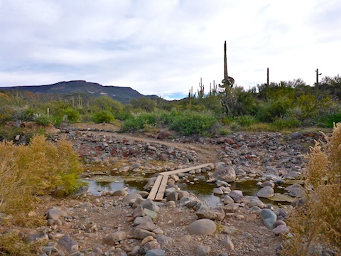
1.4 miles into the hike, Metate Trail rejoins FR 48 at a small rest area. Heading south takes you back to the parking area. I continued north, into the Tonto National Forest, crossing Cave Creek for the third time, on a third wood plank bridge.

FR 48 becomes quite rocky for several hundred yards, but then smoothes out as the road peters out into meandering trail along the west bank of Cave Creek. In early December, it has great fall color.
There are two more Cave Creek crossings. No wood plank bridges. The horror! The horror …
Just over two miles into the hike, there is a corral on the west bank of Cave Creek. Limestone Trail #252 starts out the back of the corral.
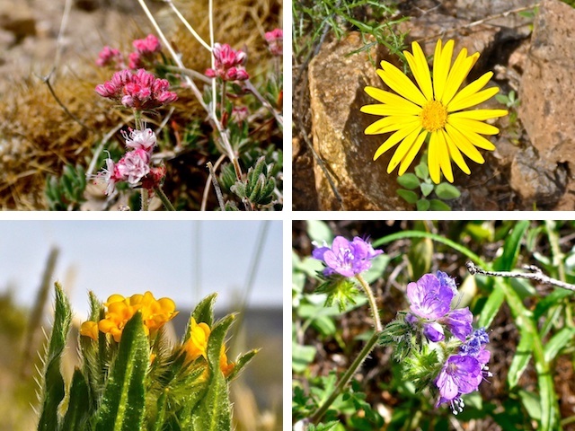
Limestone Trail #252 climbs 400 ft. in ¾ of a mile to Limestone Spring. The trail is no longer ice rink smooth like Metate Trail, but normal Arizona wild trail. (With the attendant grab & stabs.) Judging by others’ reports, the Limestone Spring box is full with decent flow between November and March, at the least. There’s lots of bees, but they are not aggressive. (I stepped across the spring box several times without being stung.) 🐝
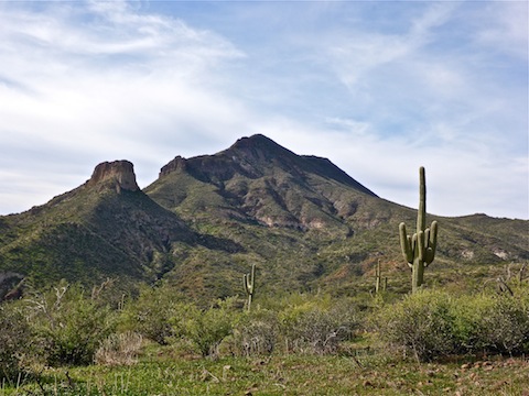
On the climb up from the corral, it looks like Limestone Trail #252 will pass west along the north slope of Sugarloaf Mountain, but instead it turns south along Sugarloaf’s east slope.
I followed the obvious trail up from Limestone Spring, but it was newly established trail. The actual trail, hidden in heavy grass, proceeds up wash for a bit, before cutting through some trees to join up with the new trail. You can’t go wrong either way.
Limestone Trail #252 climbs another 100 ft. to a saddle marked by a very old gate. That is this loop’s high point. 3.5 miles in, and with 2.7 miles to go, the only real climb of the day is done. 😅
Between the gate and Page Spring, Limestone Trail #252 descends through white rock, worn to chalky powder in many spots. I’m no geologist, but I bet that is limestone! When I passed by in 2012, Page Spring box had water. Now it is a sand box.
From Page Spring west, Limestone Trail #252 gets very rocky. It’s like wash walking. A real pain in the ass. And feet.
4.0 miles into the hike, a ½ mile west of Page Spring, there is a ‘cairn’ made of cemented rocks. Trail directions are etched in the rocks, petroglyph-style. You have a choice: 1) Either turn south, towards the trailhead, or 2) continue west on Limestone Trail #252 to Ringneck Spring, then head south on Elephant Mountain Trail towards the trailhead. Either option is very rocky, but immediately turning south saves 1.5 miles. I skipped the extra mileage. Piedra no bueno.
A ½ mile south of the petroglyph rock, the trail surface turns to jeep trail, the surface steadily improving the closer it gets to Cave Creek. For a few hundred yards it is Elephant Mountain Trail, for ¾ of a mile Tortuga Trail, then a ½ mile of Spur Cross Trail to the Metate Trail intersection, closing the loop. On weekends, this section is packed, particularly with dog walkers. On Friday, at lunch time, the only folks I saw were two old ladies resting on a bench by Cave Creek.
After crossing back over the wood plank bridge, simply head south, past the huge porta-potties and the fee station to the Spur Cross Trailhead.
Directions: From Loop 101 / Pima Freeway, head north on Cave Creek Rd. for 12.2 miles. Just as the road curves east into ‘downtown’ Cave Creek, turn left onto Spur Cross Rd. Take the next right, then a quick left. The trailhead is four miles ahead. The final mile is semi-paved but car drivable. There is no fee to park, but there is a $3 envelope fee to hike / bike / horse ride into the conservation area.
GPS File: Limestone_Trail_252_Loop
Distance: 6.90 mi.
AEG: 1,050 ft.
Time: 3h 00m
Hiking Video
Hiking Limestone Trail #252, Spur Cross from Preston McMurry on Vimeo.