

I avoid hiking high elevations, like Strawberry Mountain, in the winter. Couple of inches of snow up there the last few days. No thanx. ✋
In previous winters, I’ve ranged far & wide, particularly to the Arizona Outback, in search of interesting hikes at lower elevations.
Last winter I started doing more hikes close to Phoenix: What I term “Locals’ Hikes“. I figured there’s lots of winter visitors in the Valley of the Sun — i.e. ‘snowbirds’ — who might be interested in hikes that are not as long, with less elevation gain, not requiring a GPS, which avoid bushwhacking. Lake Pleasant Regional Park’s trails fit that bill.
Back in February, I hiked Beardsley Trail, from the Carefree Highway north to the Wild Burro Trailhead, then back. That’s nine miles, but if you have a loving wife to pick you up at the other end, it would be only 4.5 miles and 600 AEG.
There are three very short trails north of Beardsley Trail: Wild Burro Trail, Pipeline Canyon Trail and Cottonwood Trail. All are end-to-end.
Wild Burro Trail: 2.0 miles between Desert Tortoise Campground and Pipeline Canyon Trailhead. Hiking north gains 245 ft.; south only 111 ft. An out & back from either trailhead would be 4.0 miles and 356 AEG (accumulated elevation gain).
Pipeline Canyon Trail: 2.0 miles between Pipeline Canyon Trailhead and Cottonwood Trailhead. Hiking north gains 231 ft; south 293 ft. An out & back from either trailhead would be 4.0 miles and 524 AEG.
Cottonwood Trail: 1.3 miles between Cottonwood Trailhead and the North Gate. Hiking north gains 105 ft.; south only 115 ft. An out & back from either trailhead would be 2.6 miles and a very mild 220 AEG.
There are proper toilets at Desert Tortoise Campground, Wild Burro Day Use Area (0.4 miles north), Pipeline Canyon Trailhead, and Cottonwood Trailhead. There’s no toilet at the North Gate.
As our 10th anniversary was the night before, and I’d had a wee bit of champagne, I decided to hike Wild Burro Trail, Pipeline Canyon Trail and Cottonwood Trail, but only one way (north), rather than do an out & back. 🥂
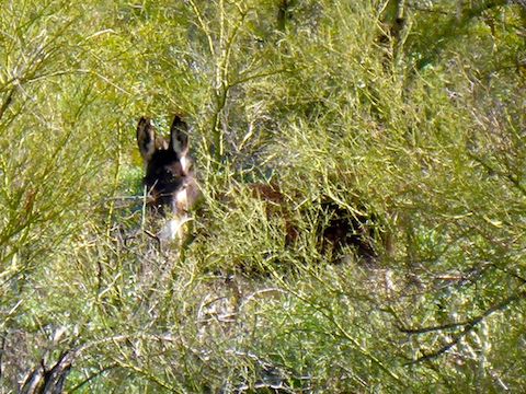
Wild Burro Trail, is appropriately named, as there are burro droppings all along the trail. Indeed, that is true along all of Lake Pleasant’s trails, across its hills, and even in the middle of its roads. (My wife & stopped to watch a small burro herd munching at the side of Castle Hot Springs Rd. as we arrived.)
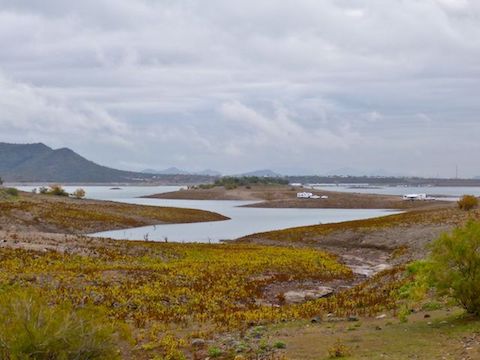
Lake Pleasant’s water levels are 5-9 ft. below recent years, but the high water line is much higher, and marked by a distinct change in vegetation. I’m guessing the high water level is 30 ft. above the current depth of 1,664 ft. If Lake Pleasant was another 30 ft. higher, Wild Burro Trail would be along the shoreline in many spots. Instead, the shore is a couple hundred yards off. Still, it has the only decent lake views.
Wild Burro Trail has the nicest surface of the three trails I hiked today. No worries about spraining an ankle: Just watch out for burro 💩!
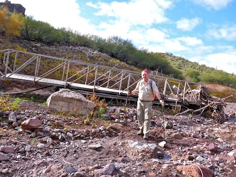
Pipeline Canyon Trail drops 200 ft. to the bottom of Pipeline Canyon. The high water line of Pipeline Cove extends a quarter mile west of the trail, which you can see on satellite view. There used to be a floating bridge there, but flash floods tore it from its moorings. It may not look it, but water has a tremendous amount of force, enough even to roll the bridge’s support blocks down channel. Pipeline Canyon Bridge’s wreckage, twisted with brush & guy lines, is 100 yds. away from its original location.
Because Lake Pleasant is low, Pipeline Cove is a dry crossing.
Pipeline Canyon Trail, then climbs 200 ft. along the west slope of the Cholla Benchmark. (The Yavapai Point Trail climbs from Cottonwood Trailhead up to the benchmark.) Halfway up the climb is a memorial bench. The trail is rocky, so take care with your footing to avoid rolling an ankle.
As I descended towards Cottonwood Trailhead, while looking out at the last sliver of Lake Pleasant view, I was startled when a previously unseen wild burro snorted me. I could see his herd moving in the palo verde.
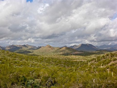
Cottonwood Trail is again decent trail surface. It crosses several sandy, gravelly, washes. There would be some shade on it, but shade was the last thing I needed as the sky was nearly 100% overcast. (It was so foggy at 8:30 a.m., that if those burros had been in the middle of Castle Hot Springs Rd., I very well may have hit them.)
Due to the sporadic sunshine, taking decent photos on my crappy pocket camera was difficult. There’s limited photo ops, anyway, on Lake Pleasant’s trails, particularly given the low water levels and people’s understandable reluctance to be on the water with temps in the 50s. Without flowers and bridge wreckage, I would have had nothing.
After my meeting my wife at the North Gate, we headed back through Lake Pleasant’s Main Gate to Scorpion Bay Marina. The parking lot is on a steep bluff. There is a stairway for fit folks, but as my wife has bad feet, we took a 6-person caged trolley down. Weeeee!
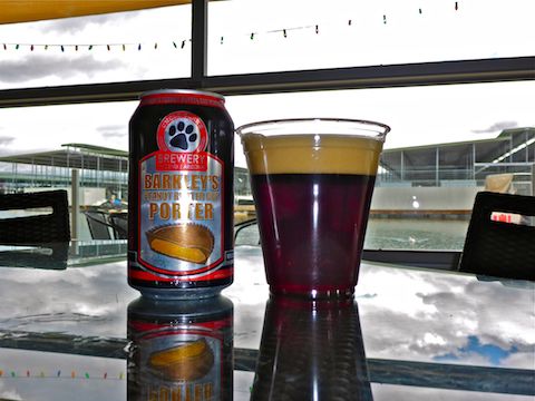
At the Scorpion Bay Grill, I couldn’t resist ordering a beer made of actual peanut butter cups. My wife didn’t really care for her panini, but I enjoyed my Cowboy Burger and battered fries. Then again, I’ve always had a thing for harbor food. (I actually liked the vending machine burgers at Cabrillo Beach Yacht Club in San Pedro!) 🍔
Directions: From Phoenix, head north on I-17. Take exit 223B onto Carefree Highway / AZ-74. Drive west for 11.5 miles. At the top of the climb from the Agua Fria River, turn right on Castle Hot Springs Rd. The park’s main gate is on the right in 2.3 miles; the north gate is on the right, at the stop sign, another 3.3 miles north. Where you park from there depends on which trails you do, in which direction. The day use entry fee is currently $7.
GPS File: Wild Burro Trail, Pipeline Canyon Trail & Cottonwood Trail
Distance: 5.80 mi.
AEG: 593 ft.
Time: 2h 10m
Hiking Video
Hiking Lake Pleasant, Arizona from Preston McMurry on Vimeo.