

This is the fourth straight year I’ve hiked in Wisconsin. Last year, I hiked the Ice Age Trail from Crooked Lake to New Fane.
After warming up the previous two days with four mile hikes around our wonderful B&B — The Inn on Hillwind — this year I continued south from New Fane, hiking 11 miles to just south of Kewaskum.
Having grown up in Wisconsin, I realize that calling mosquitoes the “Wisconsin State Bird” is not much of an exaggeration. So, I not only doused myself in Off!, I carried to the can with me for touch-ups. At least I remembered the bug juice: I forgot my sweat rag, energy gels, and some other thing, which I have forgotten to actually remember the name of. Senility sets in early. 🤷🏻♂️
I started from the public parking area in downtown New Fane, WI, right across from the Rusty Spur Saloon. (I am being facetious about New Fane’s size, but small towns in Wisconsin, are inevitably, clean, friendly, safe and great places to live.) I walked north on County S for 150 yds., before turning east on County DD, uphill for a quarter mile to Ice Age Trail Marker Mile 26. Twenty-six what, I have no idea, as there are probably 1000 Ice Age Trail miles to the south and west, with at least another 100 to go to the north end in Door County. 🍒
The Ice Age Trail is marked by a single vertical yellow blaze, Direction is indicated by a yellow arrow. The Ice Age Trail frequently crosses snowmobile trails, which are marked by an orange diamond, perhaps with a black snowmobile symbol. Bicycles, motorized vehicles and horses are not allowed on the Ice Age Trail. Horses, at least, are allowed on the snowmobile trails. Not sure about MTBs or ATVs.
There are three segments on this Ice Age Trail hike: I define a segment as being from one trailhead / parking area to another, regardless of distance; not simply where the trail crosses the road. (The Ice Age Trail crosses a lot of roads.) The segments are New Fane to WI-28, WI-28 to the Milwaukee River, and the Milwaukee River to the Kewaskum Trailhead, which is actually on Ridge Rd., just south of the Sunburst Winter Sports Park.
The first segment (4.0 miles) and second segment (2.0 miles) are very similar to the 27 miles back to Glenbeulah: Firm, only occasionally muddy trail, with occasional rocks & roots, that generally follows the highline of eskers through dense, dark, deciduous forest. There are plenty of swampy kettles and heavy trailside undergrowth to encourage the local mosquito swarms.
When you have to cross a creek, there is inevitably a wood bridge; likewise a wood walkway when the Ice Age Trail crosses a marshy area. You are never more than a half mile from a road, but being in rural Wisconsin, it is generally quiet along the trail, unless you are crossing a highway.
The first segment, from New Fane to WI-28, crosses two small roads, Kettle Moraine Scenic Dr. and Moraine Dr. (Sounds the same, but they aren’t.) WI-28 sees a fair amount of traffic, but not enough that you will be endangered crossing it, as is the case crossing WI-23, south of Glenbeulah.
The second segment is short, but road free. Shelter #1, dedicated to Raymond T. Zillmer by his long-time hiking companion Leo Tiefenthaler, is just north of County H. (Ray Zillmer is the father of the Ice Age Trail.) Like the shelters further north, it is an approximately 20 x 30 ft. four-sided wood building, with a large open doorway on one of the long sides. The structure rests on a cement 12″ cement wall, but the inside is dirt. It has an asphalt shingle roof. Like the other shelters, there is an outhouse. At shelter #1, it is a bit uphill.
If the other shelters have a handpump well, I did not notice. The only other one I remember spotting was on the edge of a kettle just south of the Greenbush Campground. In 2015, it did not work. Shelter #1 has a handpump well just downhill, and it worked great. The water was cool and delicious, just like I remember from the roadside handpumps Wisconsin’s waysides had before freeway truck stops were invented. I was a bit worried about ground contamination from the outhouse uphill, but suffered no ill effects the next morning. 💩
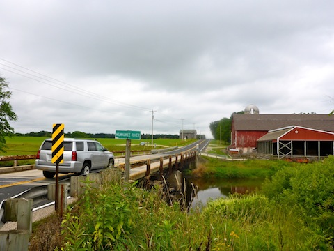
Just a few hundred yards south of the handpump well, is the first of two Milwaukee River trailheads. The Ice Age Trail is marked as continuing west from the trailhead, but it ended at Oak Dr. on the east bank of the Milwaukee River. I did not see where the trail might cross, so I returned to the trailhead, then walked down the access road to County H. I crossed the Milwaukee River on the road bridge to the second trailhead. County H does not have much traffic, but neither does the bridge have any pedestrian space should a rare vehicle happen by. Heads up!
I met my wife at the west bank trailhead, where she topped off my water. Despite being soaked with sweat head-to-toe due to humidity, I still had water in my bottle. (When I do fly away hikes, like the Jacksonsville-Baldwin Rail Trail, I bring no gear other than my GPS, camera and a single bottle of water.)
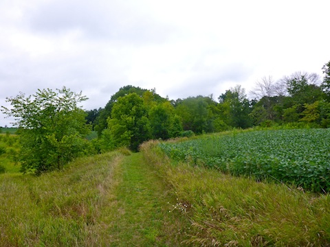
From the Milwaukee River west bank trailhead, the third segment heads southwest across a fallow farm field. (Legally, no trespassing: It is marked.) The trail then passes between corn and soybean fields before entering a small woods. On the other side of the woods, the trail crosses another fallow field, then crosses Sandy Ridge Rd., before turning northwest towards US-45.
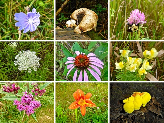
Just before US-45, the Ice Age Trail skirts a protected wetland absolutely riddled with flowers. I could have filled my memory card just with flowers photos from that wetland. 🌺
At US-45, the Ice Age Trail turns south for a hundred feet on the Eisenbahn State Trail, a gravelled jogging & biking path, before taking a tunnel under the divided highway. The tunnel does not drain, so I had to slosh through a pretty good size muddy puddle.
The Ice Trail then curves around a propane yard, and another farm field, before arriving at Prospect Dr., opposite the tiny Sunburst Ski Area. Tahoe, it ain’t.
Head a quarter mile south on Prospect Dr. to parking Lot A (marked by a blue sign). Follow the tow lift uphill past the Ice Age Trail Kewaskum Segment sign. It’s steep climb, but only 150 ft. It’s the only significant elevation change between Glenbeulah and Kewaskum.
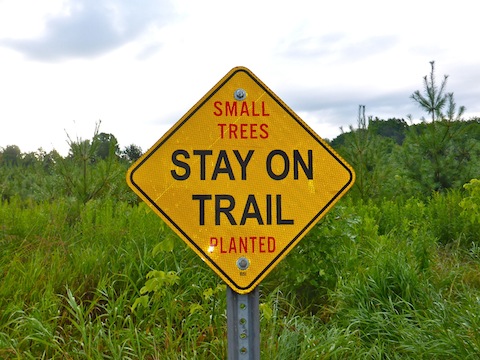
Apparently there are some other non-ski trail systems at the top of Sunburst, as I saw white and blue blazes and arrows the final mile to Ridge Rd., where the third segment ends. Rather than crossing a fallow field, south of Sunburst, the Ice Age Trail actually crosses an active soybean field. (Again, signed.) I was careful not to trample any vegan heroin.
Today’s third segment, from the Milwaukee River to Kewaskum, was my favorite so part, so far, of the Ice Age Trail. There was some actual elevation change, some views across the farm fields and, mostly, because of the scads of #flowerporn. 🌻
If you don’t do a shuttle hike, like I did, an out & back hike is a very healthy 20 miles with 1600 AEG. If you don’t have a wife to help you out, or a friend to do a key swap with, smaller out & backs, varrying from 4.0 mi. / 300 AEG to 12.0 mi. / 1000 AEG can be done by combining one or two segments.
After recouping back at the Inn on Hillwind, we spent the next three days watching sports car racing at Road America. 🏎
GPS File: New_Fane_to_Kewaskum_Ice_Age_Trail
Distance: 11.06 mi.
AEG: 968 ft.
Time: 3h 37m
Hike Video
Hiking Ice Age Trail: New Fane to Kewaskum from Preston McMurry on Vimeo.