

In 1942, thieves stole all of Hargan Mine’s gear, and burned the concentrator table and wooden pulleys. Eventually all but $350 of the gear was recovered. No word on the thieves’ fate. Webb Well, 1.5 miles west on an unnamed wash, midway between Gable Well and the Idazona Mines, was reported to have provided sufficient water for 100 cattle — in summer! — while still powering a rapid one-stamp mill. The mill / power arrastra extracted a small amount of gold and no copper of consequence. The tunnels were reported to be in good condition, guarded by a locked concrete door. A photo of the door, taken two weeks ago, showed the lock had been punched, with the door partially ajar. That photo provided the impetus for today’s mine exploration.
Hargan Mine Data Summary (1.44 meg)
According to the documents, Hargan Mine appears not to have been worked beyond the mid 70s.
If you are only exploring Hargan Mine, you can park either at the top of the Buckeye Copper Mine “loop road”, or on the west side of the small ridge, near the Bat Cave.
Regardless of whether you are only exploring Hargan Mine, or taking a side trip to Hargan while exploring Buckeye Copper Mine, the hike starts from the loop road, just before it crosses the wash near the Bat Cave. I explored both mines in one day, but have put them in separate blogs, because I blathered on too long for one blog. 😜
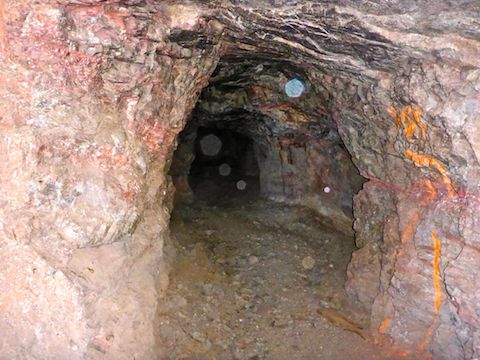
I headed up a faint foot trail, along the side wash, towards Webb Mountain. Just over a saddle, halfway up Webb Mountain’s north slope, was Hargan Mine. Supposedly there are two adits, but despite searching, I only found the one with the concrete door. It was wide open, so someone had been in there the past two weeks, since I saw the photo on HikeArizona. In I went.
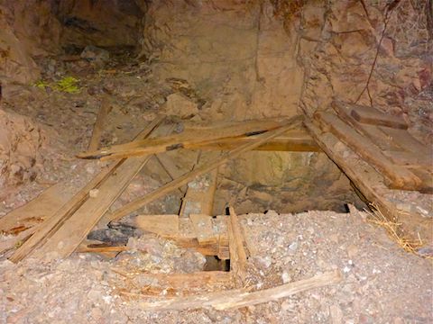
The roof and walls of the Hargan Mine adit were solid, no timbering present or even necessary. The ceiling did look dark, as if by soot from that arson back in 1942. The only “artifacts” I found were a small bed spring, a receipt for equipment rental, and an empty can of Outlaw Energy Drink. I had enough light to see, but my cheap little pocket camera was not reading the available light very well, giving some rather dark video. The adit had lots of pretty pink veins. 160 ft. in, there is a 25 ft. shaft to a drift level. I could have bypassed the shaft, but the adit ended just past it.
Back outside Hargan Mine, I started down towards Woolsey Wash. Just a few minutes later, I noticed a box of .22 long rifle. Out of curiousity, I picked it up. It was actually full! That I kept. Halfway to Woolsey Wash, by a jeep trail intersection, is about 1/3 of a round concrete block. I wasn’t sure what it was, but now I think it may have been the grind stone from the mill. (Watch the Hargan Mine video, below, and let me know what you think.) As you head west, towards Woolsey Wash, you may see a tank and wind mill; that is actually Jagow Tank, near the Idazona Mines.
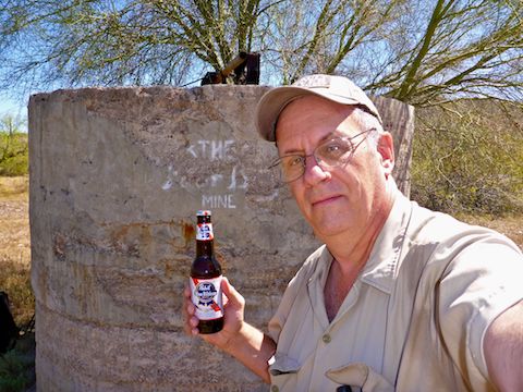
When you get to Woolsey Wash, turn south. Webb Well is just 200 yds. south, and easily spotted from the wash. The well has not worked in decades and there is no longer any water. There are no windmill remains, but a block is missing from the well’s side, so you can peer inside at the pump & gears. Adjacent to the well, are several other concrete fixtures, at least one of which is round and roughly the same diameter as the block back up trail. The blocks by Webb Well must be the remains of Hargan Mine’s mill.
Other than in the Hargan Mine adit, the only shade I found today was in Webb Well’s shadow. Depending on which way I turned I had from 1-3 bar Verizon reception. I took advantage of the shade to PBR me ASAP, eat lunch, and check my twitter timeline. Then it was back up to the pass, and down Webb Mountain, to continue exploring Buckeye Copper Mine.
Directions: From Phoenix, head west on I-10 to Exit 109. Head south on Palo Verde Rd. for 6.3 miles to the school. Turn west (then south) on Old Highway 80 for 10.9 miles. Turn west on Agua Caliente Rd., which is paved, for .7 miles. At the split in the road, split right, staying on Agua Caliente Rd. as it turns to easily car drivable dirt. There’s all kinds of jeep trails heading off to the side of Agua Caliente Rd., which crosses bajillions of washes. After a mile, just past a very small hill, turn south on an unmarked jeep trail. (You will want the GPS route, below, to find the correct jeep trail.) Follow that jeep trail southwest for 3.6 miles to a split in the trail; go left a half mile to the Buckeye Copper Mine ghost town, or go right a half mile, parking just before the wash crossing. The unnamed jeep is rutted in spots, but is easily driven by an SUV. A car might make it, with caution.
GPS File: Buckeye_Copper_Mine_Hargan_Mine
Distance: 4.31 mi.
AEG: 608 ft.
Time: 2h 30m
Exploring Hargan Mine Video
Exploring Hargan Mine, Gila Bend Mountains from Preston McMurry on Vimeo.