

I only rarely hike in southern Arizona, because getting any place cool and shady is a 3+ hour drive, and I would like to get home the day I leave. So would my wife. But as much as I like exploring canyons on the Mogollon Rim, I can only do it so often without getting bored.
Eventually, I came up with a plan to hike Green Mountain, upper Bear Canyon, and possibly Guthrie Mountain in the Santa Catalina Mountains that tower over Tucson. ⛰
Because Green Mountain Trail #21 is so short — the 3.9 miles on the trailhead sign is accurate — and the AEG (500 ft.) minimal, you may wish to add some options:
- Do Green Mountain Trail #21 bottom to top (3.9 mi., 1850 AEG).
- Do Green Mountain Trail #21 out & back (7.8 mi., 2400 AEG).
- Summit Green Mountain (1.0 mi., 500 AEG) .
- Explore Maverick Spring Trail #704 (1.0 mi., 400 AEG).
- Do Guthrie Mountain Trail #704A (1.8 mi., 650 AEG).
Do everything, and you will have a very healthy 12.0 mile and 4000 AEG day! 💪
I only did Green Mountain Trail #21, top to bottom, plus Green Mountain summit and most of Maverick Spring Trail #704 and for the next 48 hours I had trouble getting up from chairs, down stairs, or out of bed, I was so sore. Wierd.
I-10 from Phoenix to Tucson was the least traffic choked I have ever experienced. It was actually unstressful for once. However, the drive across Tucson took over an hour, due to miles of one-lane construction on Grant Rd. (We took an alternate east-west road on the way back.)
Not many cars on the Catalina Highway on a Thursday morning. Really, the only folks we saw on the way up were bicyclists on their way down — watch out for them apexing corners! — and a Pima County jail trustee highway cleanup crew. If I had to serve jail time, I couldn’t imagine a better place to do it! The hills of Mt. Lemmon were covered in green due to all the recent monsoon rain. 🚴🏻♂️
My normal hike day is Friday, but I was hiking on Thursday, because this former paratrooper figures the best way to celebrate National Airborne Day is with a “ruck march”. And beer. 🍺
Even though August is hot in Arizona — Tucson was still 100℉ when we ate dinner at El Güero Canelo — it was mid 60s when arrived at the 7200 ft. elevation Upper Green Mountain Trailhead about 9:00 a.m. Rain was predicted on Mt. Lemmon, but it only sprinkled briefly at the trailhead. After that it was most cloudy the rest of the day. (But I still got sunburned, probably due to the thinner atmosphere.)
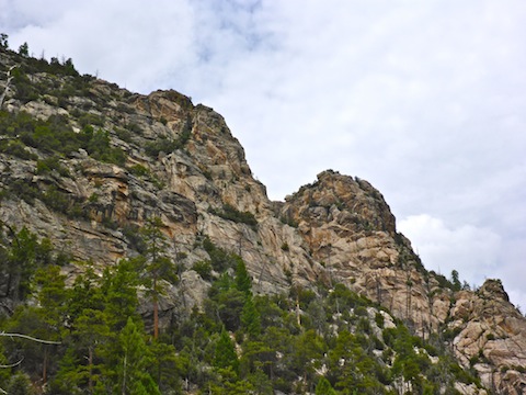
Green Mountain Trail #21 starts off with a 100 ft. climb to a saddle on the mountain’s north slope. From there, I turned right up an unsigned, but very obvious use trail. The use trail was very steep, but not as slippery as reported. My hiking poles came in handy, but you could get by without them: Just use trees & boulders for hand holds or foot brakes.
I made the Green Mountain summit in 30 minutes. First up was a meadow with rather tall grass, the key feature of which was some sort of antenna. I believe a relay station. I had heard that Green Mountain is very popular with ham radio operators, but a relay was a more permanent installation. Being a former 05B1PA4*, I raised a toast to the antenna. The beer was Efes, which we drank by the Humvee-load in Kurdistan, after the Gulf War.
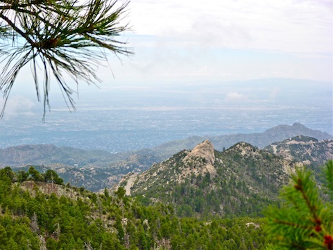
I had heard Green Mountain’s summit had good views, but other than than decent shot back down the Catalina Highway towards Tucson, the views were mostly blocked by brush. At least the summit was relatively flat. It would make a good camp spot, with a thick bed of soft pine needles.
Speaking of having good comms, my Verizon signal on Green Mountain was good enough to do twitter. I also had a strong signal at Bear Saddle. Nothing in the depths of Bear Canyon though. 📱
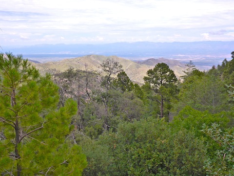
On the way back down Green Mountain, I found a great OP 100 yds. northeast of the use trail. Check out the attached GPS route for its location. I could see Redington Pass, and east all the way across the San Pedro River valley to the Galiuro Mountains.
Back on Green Mountain Trail #21, I headed east, down from the saddle. Just a couple hundred yards on, there was an unsigned split in the trail. I went right. I chose wisely.
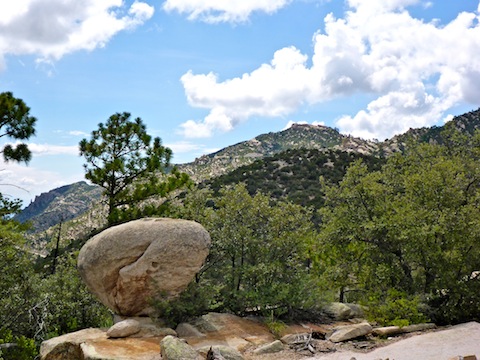
Just past the unsigned intersection were two boulders defaced with blue graffiti. Not just unnecessary directional arrows either. Hopefully, whoever did it fell off the cliff. 🖕
There followed two signed intersections, at 0.3 miles and 1.5 miles, for Brush Corral Trail #19, which ends five miles down in Buehman Canyon. Since the top end, on the slope of Green Mountain, is a lasso, that lasso is another option you can do off Green Mountain Trail #21. It’s a lot of wallop in a short distance.
The intersection of Maverick Spring Trail #704 is at 1.9 miles, and Guthrie Mountain Trail #704A at 2.0 miles. Both are signed. The Maverick Spring turn off is by a pair of large, upright, wedge-shaped boulders. After a break, I considered skipping Maverick Spring, but seeing as it was Airborne Day, I couldn’t puss out. Besides, it was short. 😁
Maverick Springs Trail #704 had more shade than Green Mountain Trail #21. The trail was in good condition, but I stopped short of Maverick Springs, when it dead ended in a tangle of dense vegetation. I didn’t bring a machete, so back uphill I went.
Back at the upright boulders, I headed from Bear Saddle down upper Bear Canyon. I stayed on Green Mountain Trail #21, but where it crossed the floor of Bear Canyon, that looked like it would be the better option. The floor of Bear Canyon seemed to be easy travel.
Green Mountain Trail #21, on the other hand, went up & down as it descended, with extensive stairing that may have blunted erosion, but which wore out my legs. The trail crossed several large slick rock areas, and seemed to form part of the fireline where last July’s Burro Fire was halted. The final half mile to General Hitchcock Campground was basically flat.
I never saw any bear scat, but I regularly clicked my hiking poles together to ward off any bears that might be in Bear Canyon. The only critters I saw all day were a small horny toad on Green Mountain and a hummingbird on its slope. 🐻
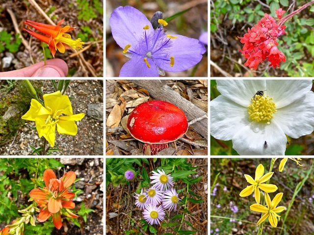
The hummingbird was feeding on some orange flowers that I was photographing. There was great #flowerporn all along Green Mountain Trail #21. I saw at least a dozen species, in a wide variety of colors: Red, yellow, white, purple, orange, etc. The flowers tended to occur in species-specific bunches, rather than mixed along the trail. Plus, I saw several varities of mushroom, including a stunning red cap mushroom. Or, as I like to think of it, a “maroon beret mushhroom”.
Directions: From I-10 in Tucson, take Exit 256. Head east on Grant Rd. for 8.5 miles. Turn left onto Tanque Verde Rd. In 3.3 miles, turn left onto the Catalina Highway. In 16.4 very twisty miles (speed limit 35 mph), the General Hitchcock Campground will be on the right. Another 5.3 miles up the Catalina Highway, the Upper Green Mountain Trailhead will be on the right.
GPS File: Green_Mountain_Trail_21
Distance: 6.56 miles
AEG: 1,248 ft.
Time: 3h 24m
Hiking Video
Hiking Green Mountain Trail #21, Catalina Mountains from Preston McMurry on Vimeo.
Nice change of pace.
It certainly is an area I need to hike more!
Beautiful flowers and loved the hummingbird.
Thanx! I’m surprised the hummingbird got so close.