
 Two Rock Mountain, Little Granite Mountain and Granite Mountain.")
It’s been over two months since Prescottstyle and I hiked together, to the Granite Mountain Hotshots Juniper. He suggested we hike the Granite Dells and Watson Lake.
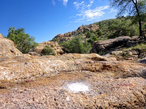
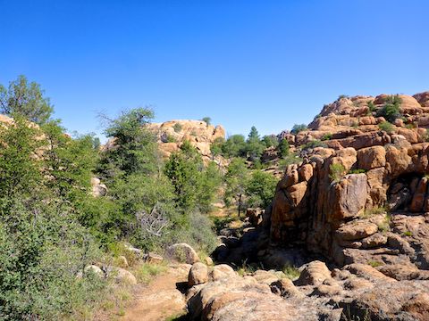
The Granite Dells are roughly three miles long by two miles wide, north of Willow Lake and Watson Lake. The Dells’ granite is 1.4 billion years old and uranium rich. Originally crystallized magma as much as two miles deep, spheroidal weathering has turned the Dells’ granite into today’s striking formations.
Just last year, the City of Prescott purchased 160 acres northwest of Glassford Hill, in the Granite Dells. The Over The Hill Gang, an officially recognized volunteer group, subsequently added the Storm Trails system, 6+ miles of additional trails named after a nearby ranch.
The Storm Trails includes at least 19 named trails: Captains Trail, Easter Island Trail, Big Piney Trail, Big Piney Connector Trail, Big Rock Canyon Trail, Boulder Creek Trail, Northwest Passage Trail, Northwest Passage Connector Trail, Blaster Trail, Dino Canyon Trail, Century Trail, Gap Trail, Black Hole Trail, Quartz Canyons Trail, Bedrock City Trail, Pebbles Trail, Rooster Point Trail, Bam Bam Trail and Yabba Dabba View Trail. I may have missed one. The shortest is only .04 miles; the longest a whopping 1.13 miles. I’m bummed there is not a trail named after Great Gazoo. 👽
Access to the Storm Trails is via the Peavine Trail. A National Recreation Trail, Peavine is a rail trail that currently extends 5.5 miles from the Sundog Ranch Trailhead to the North Peavine Trailhead at Arizona Highway 89A, adjacent to Tri-City College Prep High School.
It’s hard to get lost on the Storm Trails. Like I always say, “You are not lost unless you both don’t know where you are and don’t know how to get to where you want to be.” 🧭
This being my first time hiking the Granite Dells, I cannot attest to the remainder of the park, but at least along Peavine Trail, and in the Storm Trails, each trail intersection is marked by a map of the full Storm Trails system, with relevant terrain features, and a black dot indicating current location. In addition, all the Storm Trails’ actual paths are marked by a spray-painted white dot every 100 ft. or so.
The Sundog Ranch Trailhead has over 60 parking spots, plus four handicap spots and nine horse trailer spots. No motorized vehicles are allowed on the Peavine Trail or Storm Trails. Hiker-only trails are indicated, but otherwise hikers share the trails with mountain bikes and horses. Pets are allowed, but must be leashed.
After picking up an excellent trail map at the trail register, we headed down the Peavine Trail. Such as “down” is.
Peavine Trail was exactly what you would expect a rail trail to be: wide, smooth & flat. It only descends 200 ft. in 5.5 miles — which is the Grand Canyon compared to the C&O Canal.
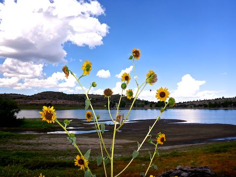
There were lots of birds — primarily geese, with some ducks and a single Great Blue Heron — on the shallow, muddy, southern shore of Watson Lake. They were too far away to shoot with my dinky pocket camera: I would have need a tripod and zoom lens. If you hear shots, it isn’t duck hunters: It is cops. 👮🏻♂️
The industrial area on the right, at the beginning of Peavine Trail, is a Prescott city facility, including a fire department burn tower and a police department outdoor range. Mind the “CAUTION: Hazardous conditions exist. Please stay on trail.” signs.
Just after a railroad cut, there is a gate on the right: That is Captains Trail. I’m not sure why the Storm Trails system is fenced off, and gated at each access point. There are no cattle in the area.

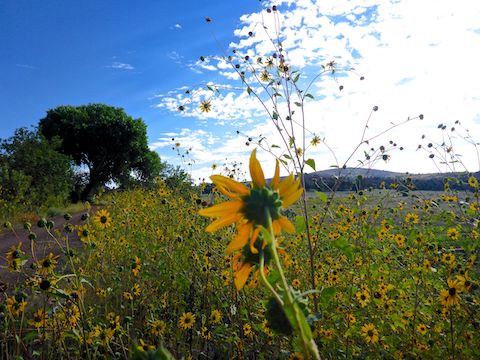
Captains Trail is only 0.72 miles, with 143 ft. of elevation gain. There’s a little bit of shade after a ⅓ of a mile, and some decent Watson Lake photo ops at the ½ mile mark. But there is better to come! Just before the end of Captains Trail, and the start of Easter Island Trail, there is a use trail off to the left. A few yards over is a rest bench and great views of Watson Lake, the Granite Dells and, in the distance, Granite Mountain. That rest bench is where I took the photo at the top of this blog.
Easter Island Trail has even less shade than Captains Trail. In it’s 0.67 miles, it connects to Peavine Trail, Captains Trail, Big Piney Trail, Big Rock Canyon Trail, Gap Trail, Century Trail & others. Up and down over more granite formations, it can’t be more than a hundred feet of AEG. Our sweat was due to to rapidly rising temperatures. 😅
After 250 yds. on Easter Island Trail, or maybe a ¼ mile from Peavine Trail, the vertical boulder which gives Easter Island Trail its name — it resembles the moai on Rapa Nui — came into view on our left. The trail wraps around the boulder, so Prescottstyle & I took photos from multiple angles & distances.
It was warming up quick enough that Prescottstyle & I decided to forgo hiking out to the Flintstones-themed trails at the far end of the Storm Trails system. Instead, we turned up Big Rock Canyon Trail.
Big Rock Canyon Trail starts just after the Easter Island boulder. It is only 0.28 miles long. Besides Easter Island Trail, it connects to the Big Piney Connector Trail, Boulder Creek Trail and Blaster Trail. While eyeing some shade, I got rattled. I looked high & low for the culprit, but could not spot him in the darkened rocks, branches and leaf litter. Prescottstyle & I kept moving. 🐍
Boulder Creek Trail is 0.53 miles. Since we just took it back to Peavine Trail, I’m clueless how much AEG it might have. Certainly not Matterhorn, or even Glassford Hill, levels of gain. Boulder Creek did have some water, but the flow was so light it was inaudible.
A ¼ mile back up Peavine Trail, we diverted onto Lakeshore Trail for a ½ mile. The highlight was a closeup of the cove pictured in the top photo. Unfortuately, no kayaks were paddling nearby.
As Prescottstyle & I headed south on Peavine Trail, big clouds started rolling in. We barely made it back to the trailhead’s covered picnic area before the rain started. 🌧
Directions: From Phoenix, head north on I-17 to Exit 262. Head west on AZ-69 for 30.5 miles. At the mall, turn right onto Prescott Lakes Parkway. In 1.5 miles, just past the jail, turn right onto Sundog Ranch Rd. The trailhead is just ahead on the left. Parking is $3 (free on Wednesday).
GPS File: Peavine_Captains_Easter_Island_Big_Piney_Loop
Distance: 5.24 miles
AEG: 544 ft.
Time: 2h 06m
Hiking Video
Hiking Prescott’s Granite Dells from Preston McMurry on Vimeo.