

With temperatures soaring in Phoenix, I headed north to the Mogollon Rim. At 7500 ft., the Rim is 500 ft. higher than even Flagstaff. At 62°, and breezy, it was twenty cooler than Phoenix when I started hiking at 8:30 a.m.
Before I started hiking, my wife and I checked out the General Springs Cabin. (I parked just across FR 705, so she could check it out as well.) Despite being maintained for “your heritage”, no one is actually allowed to use it, and it is full of rat 💩. And probably hantavirus.
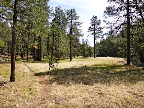
Despite the Mogollon Rim’s escarpment facing south, it actually drains north, towards East Clear Creek and Chevelon Creek. As I’ve been gradually working my way through the Mogollon Rim’s named tributary canyons, I hike north, down canyon, then take a ridge top forest road south back to the trailhead. (The ridges between each canyon are riddled with forest roads.) That way the physical bushwhacking part of my day isn’t multiplied by elevation gain. But Fred Haught Canyon looked like it might be clearer than Crackerbox Canyon, so I flipped my routine.
Fred Haught Trail #141 starts at the rear of the General Springs Cabin, which is the start of the Cabin Loop. Depending on how you hike it, the Cabin Loop is 25-31 miles with five historical Forest Service cabins: General Springs Cabin, Fred Haught Cabin, Pinchot Cabin, Aspen Spring Cabin and Dane Spring Cabin.
The furthest I’ve hiked in a day, at least as a civilian, was 18 miles doing an Aravaipa Canyon thru-hike. (I did some 20 mile ruck marches in the Army, and the furthest I’ve walked in a day is 30 miles while hitchhiking across Utah. 😅)
I hiked a shorter option, about a third of that distance: Fred Haught Trail #141 3.3 miles down General Springs Canyon to Fred Haught Spring at the base of Turkey Pen Ridge, bushwhack 3.2 miles up Fred Haught Canyon to FR 95, then follow FR 95 and Rim Rd. / FR 300 2.5 miles back to General Springs Cabin. I expected accumulated elevation gain (AEG) to be about 750 ft.
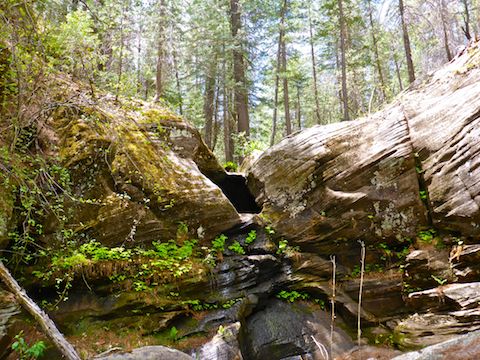
For the first three miles, Fred Haught Trail #141 is co-located with Arizona Trail passage #28. After signing in at a the trail register, it mostly follows the shelves at either side of the creek. (Other than crossing a small spur a half mile down General Springs Canyon.) The creek was spotted with small pools, but had minimal flow. For some reason, there is a metal tube fence around the creek for a few hundred yards north of General Springs Cabin.
Throughout the loop, all creek crossings can easily be done dry.
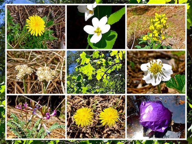
There were not a lot of flowers, but enough to keep me regularly getting down in the dirt for decent #flowerporn closeups. Almost all the flowers I saw were in General Springs Canyon, not Fred Haught Canyon. I spotted maybe a dozen species, but 95% of the blooms were dandelions. Some people may think of dandelions as “weeds”, but I think they are pretty. 🙂
On my way north, I heard a helicopter. It was probably dipping at Blue Ridge Reservoir to fight the still smoldering 16,000 acre Tinder Fire.
At Fred Haught Spring, the Cabin Loop continues north. I turned south towards Fred Haught Cabin.
Just as I entered the wash, I spotted a couple of backpacks nestled under the shelf, out of sight of the trail. I figured it was for the folks I saw sign in the trail register the day before me, and a minute later I saw them emerge from the woods with their two dogs. (One friendly, the other a bit wary.) We chatted for a minute, them mentioning Fred Haught Canyon gets pretty congested above his cabin. I replied that I like beating brush. (A bit of a stretch, but that is what I was there for. 😉)
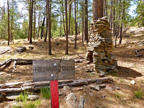
Though a trail sign said Fred Haught Cabin was 0.5 miles, it is more like a ⅓ of a mile. All that’s left is the cabin’s fireplace. As far as the cabin’s remains, this hike is kid-friendly.
As I headed south up Fred Haught Canyon, it definitely tightened up, but never to the extant of East Miller Canyon. There were more pools, but still nothing one could wade in. Most obstacles were easily avoided. The only slight delay was caused by a 15 ft. pour. Younger, more agile, hikers could scramble up it’s slippery face, but it took me a few minutes to figure a safer old guy way around it. 👴🏻
There are several small side canyons on this hike. You will want to load the attached route in your GPS before you start.
I took two short breaks in Fred Haught Canyon, munching gorp and my usual salt & vinegar ships. The difference in air pressure from Phoenix had the unopened chip bag near to bursting. Both breaks, I sat up against a pine tree, and watched the tree tops rustle in the breeze. I could have spent hours sitting there, but my wife was expecting me back at General Springs Cabin.
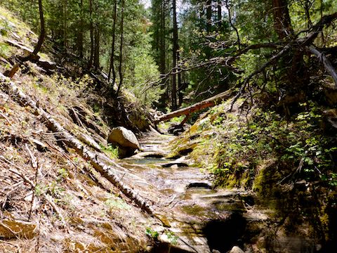
Forest Road 397 and 397A parallel Fred Haught Canyon for most of its length. If you need to bail, the road is only about a hundred yards to the East. Both connect to FR 95.
At the head of Fred Haught Canyon, I started waking south on FR 95. After three quarters of a mile, I wandered off on what I thought might be a short cut. It wasn’t really worth it. I’d stay on FR 95, then Rim Rd., if I were you.
When I got to the Mogollon Rim, the wind was howling. I guessed at least 60 mph, and I was not wrong. (I checked the weather after I got home and winds all across northern Arizona were over 50 mph.) The canyon really focused and accelerated the wind as it blew up slope from Washington Park. It was so windy, I couldn’t hold my camera steady and was nearly blown off my feet. No lie.
Lots of shade on this hike, and I still somehow managed to get sunburned. 🙄
Back at General Springs, my crappy Garmin 62S claimed I had 1900 AEG; it turned out to less than 900. I kissed my wife, rehydrated, and then we headed back to AZ-87. Since it was mid-afternoon, we decided to stop at the first restaurant we saw in Strawberry. It turned out to be “Bandits”, a year old western-themed joint. The burgers were good and the coleslaw excellent. 👍👍
Directions: From Phoenix, head north on AZ-87, the Beeline Highway, through Payson, Pine and Strawberry. (Alternately, take I-17 north, then AZ-260 east.) 2.6 miles north of AZ-260, turn right onto Rim Rd. / FR 300. Rim Rd. is dirt and, at its western end, twisty and very bumpy. I would not do it in a car. In 12 miles, at the Battle of Big Dry Wash monument, turn left onto FR 705. A ¼ mile downhill, park at General Springs Cabin.
GPS File: General_Springs_Haught_Canyon_Loop
Distance: 9.55 mi.
AEG: 836 ft.
Time: 3h 56m
Hiking Video
Hiking General Springs Canyon & Fred Haught Canyon from Preston McMurry on Vimeo.
The temperature was great. while i was waiting I could hear a lot of noise in the pine trees from the wind blowing so hard. It was still a wonderful location to rest.
Glad to see you left your mark (in the woods, that is).
😆