

Though earlier in the week Phoenix finally hit 100° for the first time this year, the high temp was supposed to drop right back down, plummeting to the low 80s for a full week after that. At the same time, Arizona’s higher elevations were getting socked with late season snow. (Arizona Snowbowl, with 346″ of snow fall for the season, was still open this weekend!) ⛷
Given the pleasant reprieve, I decided to hike somewhere in the lower elevations, closer to my home in Sunnyslope, in central Phoenix.
The hike I decided on was a loop in the central Superstition Mountains: From Woodbury Trailhead, to Woodbury Well, then down Fraser Canyon via Coffee Flat Trail #108 to Dripping Spring. I would return via Randolph Canyon, first on Red Tank Trail #107, then on use trails to JF Trail #106, which I would take back to Woodbury Well, then Woodbury Trailhead.
Woodbury Trailhead is accessed via FR 172 (see driving Directions, below). The furthest I had ever been up rocky, bumpy, FR 172 was a climb up Roblas Butte back in 2016.
Roblas Butte is only three miles from FR 357 — appropriately numbered for all the impromptu gun ranges along it — while Woodbury Trailhead is another eight, more rugged, miles. I drive a stock 2013 Acura RDX AWD, with only 7.5″ of clearance. Granted, that is more than the 4.5″ common in cars, but it is also less than you find in vehicles designed for serious off-roading, like a Jeep or Toyota FJ Cruiser, or even a Ford F-150. 💪
So, I took my time driving up FR 172, enjoying the views, and taking care in what to me were trickier sections. The last thing I wanted was a flat, or to puncture the oil pan, as FR 172 has no cell reception at all. It took me 1h 15m. I started hiking at 8:30 a.m.
The Fraser Canyon-Randolph Canyon Loop starts off with a short, slippery, 100 ft. climb up an old jeep trail that doubles as JF Trail #106. As the trail descends towards Woodbury Well, La Barge Mountain appears 2.5 miles to the northwest.
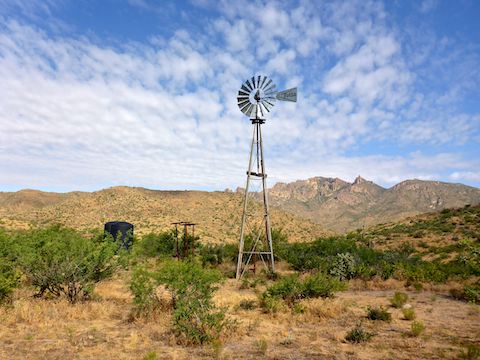
The turn off for Coffee Flat Trail #108, down Fraser Canyon, is just before Woodbury Well, and is marked by a cairn. But first I explored the well. 🚰
Woodbury Well has a windmill, but it no longer operates the pump, which is now solar-powered. At the base of the windmill was an elevated rubber pipe end, which was giving a steady flow of clear water. Two adjacent large plastic tanks sound like they were both full. (I knocked.) A spring box was dry, but a cattle tank was close to full. There were a number of well-licked salt blocks laying about.
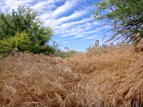
After checking out Woodbury Well, I headed down Coffee Flat Trail #108, which is single track. Though there was some foxtail, the trail was obvious, and well-marked by many cairns.
Coffee Flat Trail #108 drops 300 ft. in a ⅓ of a mile, before assuming a gentle, and consistent slope of -200 ft. per mile for the next three miles to Dripping Spring. 1.5 miles into the hike, is colocated for several hundred yards with FR 172B, the JF Ranch access road.
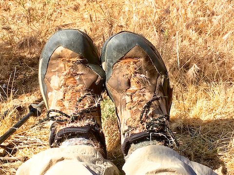
At JF Ranch, Coffee Flat Trail #108 skirts the corral, passing through dense foxtail. So dense, the trail virtually disappears. (I could only discern the trail’s location by looking at the direction the foxtail was bent.) If you have never encountered foxtail, trust me, you don’t want to: It is worse than cholla cactus, working its way into all the seams and holes in your socks and shoes, and stabbing you like a thousand irritating needles. 😩
West of JF Ranch, Coffee Flat Trail #108 criss-crosses Fraser Canyon multiple times. I stayed on trail, despite the foxtail, to lay down an accurate track (see below). If the foxtail are bad — as they tend to be in wet years like 2019 — you’d be better off walking the canyon bottom.
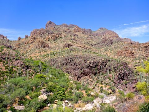
Fraser Canyon gets pretty tight for the next two miles, past Whetrock Canyon and Musk Hog Canyon, to Dripping Spring. There’s a decent amount of shade, and lots saguaro on the canyon slopes. Near Whetstone Spring, I found an mine adit that went in less than 50 ft.
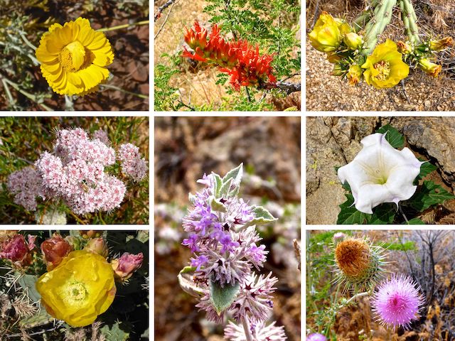
Top Row: Desert Marigold, Ocotillo, Cholla.
Middle Row: Flat Top Buckwheat, Desert Lavender, Sacred Datura 🧘🏻♂️.
Bottom Row: Prickly Pear Cactus, New Mexico Thistle.
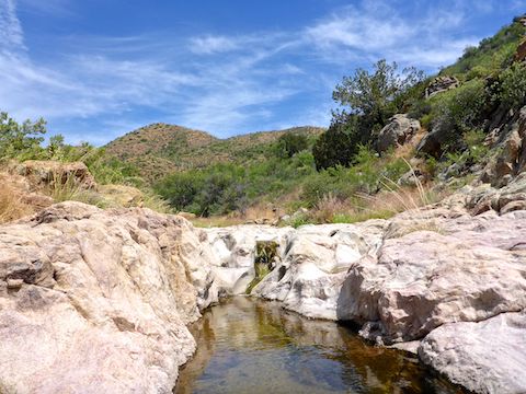
Coffee Flat Trail #108 intersects Red Tanks Trail #107 just before Dripping Spring, which is located at the junction of Faser Canyon and Randolph Canyon.
Dripping Spring had some great shade, and decent sitting rocks. The spring itself is really a seep, leaking out of the canyon walls amongst damp grasses, mosses and leaves. Look for the plants stained purple: That’s Dripping Spring.
I took a break at Dripping Spring, contemplating my foxtail riddled shoes & socks. I decided it would take too long to de-foxtail them, and that the existing infestation might somewhat innoculate me against further foxtails I might accumulate in Randolph Canyon. 🤔
After my break, I started up Red Tanks Trail #107, which passed by some pools and pretty purple boulders & slick rock. Along the way, I encountered a gila monster — the first one I’ve seen in the wild since I hiked from the Bronco Trailhead to Cave Creek in 2016.
After a ½ mile, Red Tanks Trail #107 heads north while Randolph Canyon continues northeast. I thought at first I might have found a use trail, but it quickly disappeared. I really did not want to fight catclaw for four miles, so I stuck to the rocky canyon bottom. That got old quick.
Though Randolph Canyon only climbs 500 ft. in the 3.5 miles to JF Trail #106, it felt like I was climbing stairs the whole way. My leg muscles got so tired, I briefly considered turning back, and even had non-sensical thoughts like “drop pack” and “cross country would be easier”. Both would have been bad news. I had to gut it out.
A few minutes before I reached Randolph Spring, I came within 5 ft. of a western diamondback sunning itself on a pink boulder. Naturally, I jumped back, but he never did rattle me, or even coil. 😅
There were trickles and pools all along Randolph Canyon, both below & above the check dam at Randolph Spring, which marks the halfway point between Red Tanks Trail #107 and JF Trail #106. In many cases the flow was audible. Sometimes the water had algae, other times it was clear.
Despite mostly staying in the rocky bottom of Randolph Canyon, I still accumulated scads more foxtail, as I occasionally had to work my way around an obstacle, trying to keep my stabby feet dry. (I eventually gave up staying dry.)
Two and a ½ miles up Randolph Canyon, I was dead tired. Naturally, that is when I encountered a 2-3 ft. high fence, across the wash. I’ve seen read that there is a gate in the brush on the side of the wash. Not knowing it at the time, I wondered how I could lift my weary legs over the fence, as there was no room to low crawl it. Even if there was, I did not have the energy to get back to my feet. After contemplating my options for a few minutes, I settled for stepping on the fence, depressing it enough that I was (barely) able to lift my other leg over it.
Finally, at the 8.9 mile mark, after 3.5 tough miles in Randolph Canyon, I came to JF Trail #106. Though there is a cairn, the trail is faint. If you miss it, and really enjoy rock hopping, JF Trail #106 crosses Randolph Canyon a second time, in another half mile. I opted to climb the 150 ft. out of the canyon, stopping several times along the way for 10 seconds here and 15 seconds there. I was spent. 🚑
I soon passed by Woodbury Well, closing the Fraser Canyon-Randolph Canyon loop. About halfway between the well and the trailhead, I got rattled by a second western diamondback*, on the left side of the jeep trail. Surprised, I did the hokey pokey back step. After gathering my senses, I walked around him.
I returned to the Woodbury Trailhead at 4:10 p.m., after nearly eight hours of hiking. (I might have taken even more time, if I was not concerned about getting back to pavement before dark.) Cold beer never tasted so good!
Directions: From Phoenix, head east on US-60 until it turns from freeway into two lane divided highway. Two miles east of the AZ-79 interchange, turn left (north) onto paved Queen Valley Rd. In 2.8 miles, split right onto the good dirt surface of FR 357 / Hewitt Canyon Rd. In 3.2 miles, turn left, crossing Queen Creek, onto FR 172, which is rocky & bumpy and crosses many further washes. Cars have made it the whole 9.6 miles to Waterbury Trailhead, but I would not try it. I recommend an SUV or better. (Especially as you are out of cell range the whole way.)
GPS File: Fraser_Randolph_Loop
Distance: 11.45 mi.
AEG: 1,265 ft.
Time: 6h 07m
Driving FR 172 to Woodbury Trailhead
Woodbury Well
Hiking Video
Hiking Fraser Canyon & Randolph Canyon, Superstition Mountains from Preston McMurry on Vimeo.