

My wife Bernie and I were in Las Vegas to celebrate the 50th Anniversary of the Lisbon Lions winning the European Cup in 1967 at a convention hosted by the North American Federation of Celtic Supporters clubs at the Westgate Resort & Casino. (The guy who owns Westgate is the same befuddled octogenerian featured with his trophy wife in the “Queen of Versailles” documentary.)
After getting steaming at a sesh — Scottish slang for a drinking bout — on Wednesday, I woke up with barely a hangover on Thursday morning. It was a wise decision to drink the flavored water found in Bud Light cans, rather than Stella or some double IPA.
Bernie & I had some sort of special room package that allowed us access to a “concierge lounge” where there was a full buffet, I guess all day. So, I stocked up on alcohol absorbing foodstuffs such as bacon, biscuits & gravy, bacon, pastry, and more bacon. Plus a couple of cups of orange juice, for the vitamin C. And bacon.
Since they are reconstructing the mess that is the downtown I-15, I-515, US-95 interchange and approaches, we headed west on Sahara, then north on Decatur Blvd. before picking up the 95. Once we cleared NV-215, the traffic lessened. There were no obvious asshole drivers, as we headed the opposite direction of rush hour. I almost missed the NV-157 turn, as I was expecting a freeway exit to the right, rather than a normal highway left turn. Bernie spotted the only roadside memorial we saw on NV-157.
About 10 miles up NV-157, my low fuel light pinged on. Fuuuck. As there was a convention event at 2:00 p.m. — unfortunately rescheduled from 4:00 p.m. 🙄 — I did not want to waste time doubling back to search for a gas station. (There was nothing at the US-95 / NV-157 intersection.) I figured there had to be fuel at Mount Charleston, even if it was only a single pump of 83 octane selling for $5/gallon. I intended to hike to the top of Cathedral Rock and Little Falls from near the Mount Charleston Lodge, so we pressed on.
We arrived at the lodge with my Acura RDX’s onboard computer estimating I had 18 miles of fuel remaining. I asked a waitress where there was a gas station. She said there wasn’t one. Oh, great.
I went to my backup plan, which was to hike Fletcher Canyon, three miles back.
We started back down the hill, stopping along the way at the Fire Department, figuring I might be able to buy a couple gallons. No one was around.
After we arrived at Fletcher Canyon, my wife and I discussed what to do. Eventually, I hit on the idea of calling AAA, of which we are both members. Get this: AAA won’t help you if you are so low on fuel you won’t make it to the nearest gas station. AAA wants you to actually run out first. 😡
The second time I called AAA, I lied.
Since my wife has bad feet, she usually waits for me at the trailhead or, if we are near civilization, goes shopping while I hike. So, she waited for AAA to arrive while I headed out. If not for her, I wouldn’t have been able to do this hike. 😍
The pit toilet at Lake Mead Recreation Area, just west of Hoover Dam is our regular last pee break on the way into Las Vegas. Normally, it’s not bad. Two days earlier, I could smell it from 60 ft. away. Inside my car. 😳
It was the worst smelling toilet I have ever encountered. Not even the PakBat toilets in Bosnia smelled that bad! We won’t be stopping there again. Thankfully, the Fletcher Canyon trailhead pit toilet was no issue, and I was able to walk past it without fainting.
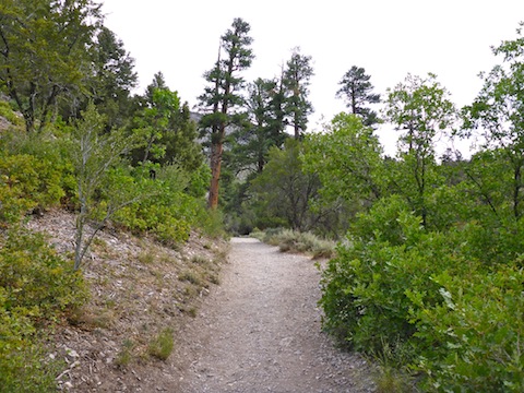
Fletcher Canyon Trail begins just across the road, on the north side of NV-157. It is wide & smooth, with gravel varying from marble to golf ball size, but mostly flat rocks, rather than rounded, so ankle spraining is not an issue. No need to stop moving to enjoy the beautiful scenery and towering canyon walls.
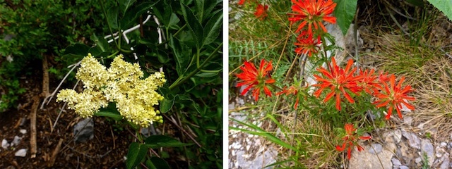
Despite being in a forest, the vegetation is rather open. As in most pine woods, there are few grab & stabs. There also were not many flowers: I spotted maybe a half dozen species, and then only a few instances of each. I found penstemon, paintbrush, Crimson Columbine, Western Blue Elder, Nuttall’s Linanthus and what was possibly a non-fruiting Virginia Strawberry (though, apparently, those are rare in Nevada).
Fletcher Canyon Trail crosses the wash a half dozen times between NV-157 and Fletcher Spring, after which the trail mostly disappears and you hike straight up the canyon bottom. I saw no standing, let alone running, water below Fletcher Spring. All the wash crossings were dry.
There were several sections of disconnected metal spring pipe along Fletcher Canyon Trail, all marked with graffiti.
I spent some time searching the Fletcher Spring area, but never found the source. I did, however, find a small cave covered with “modern petroglyphs”. 🙄
On my way up canyon, I passed a group of talkative young adults (with selfie stick), and saw two pairs of hikers already heading back. I saw a plastic-topped coffee cup laying on the ground, which I picked up. It seeped coffee on my hand. One of those couples dropped it.
Thank you for your contributions to nature’s beauty. 🚯
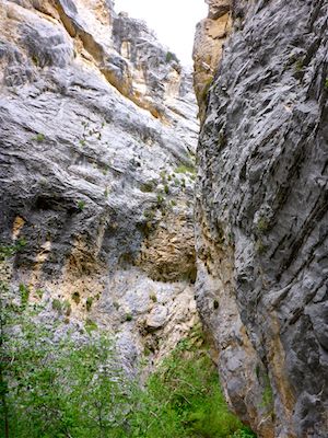
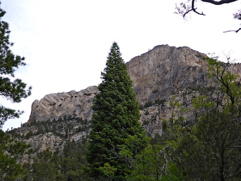
The canyon walls don’t gain altitude as rapidly as the canyon floor, so as you head up canyon, the canyon becomes shallower. Above Fletcher Spring, it also gets much tighter, slotting to a point where your spread arms can touch both sides. The walls remain sheer the whole way.
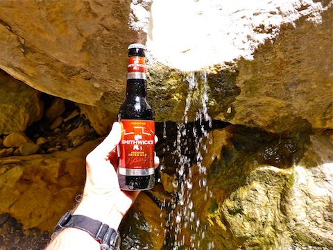
I finally found water about 500 yards above Fletcher Spring. On the topo, there is an unnamed spring symbol. Pouring over a small boulder, the flow was light but quite audible. The water soaked into the sand at the bottom of the spill.
As I settled in to take more pictures, the talkative young adults caught up to me. I said, “Hey, I don’t mind you talking, but if you could give me 30 seconds of quiet to film the ‘falls’, I would appreciate it.” They agreed … and were quiet for maybe 10 seconds. 🙄
Rather than cause a scene, I sat back against the canyon wall to relax, while they explored — and talked, and talked, and talked some more — above the spill. After about 30 minutes they finally started back down canyon and, as a gesture of goodwill, I took a group photo of them. 🙂
It is possible to continue hiking up Fletcher Canyon: It’s about another 1300 AEG in a little over a mile. So, quite steep, but doable. North Loop Trail #146 is at the top of Fletcher Canyon, and can be used to access Cockscomb Ridge, Fletcher Peak, or even Mount Charleston itself. A one way shuttle hike to the Mahogany Grove picnic area, or Hilltop campground, would be about 7.5 mi. and 3200 AEG.
I made quick time back to the trailhead on Kyle Canyon Rd., passing probably another dozen people, and a dog, heading up canyon. Thankfully, my vehicle had been refueled in the interim — my wife said he was a very nice guy — so we were able to hasten back down to Las Vegas, stopping only for fuel at a ghetto station on Sahara, in time for the 2:00 p.m. showing of “Anyone But Celtic”.
Directions: Head north on US-95. Four miles north of NV-215, just after US-95 changes from freeway to divided highway, stay left. At the first intersection, turn left onto Kyle Canyon Rd. (NV-157). The road climbs steadily from 2800 ft. to 6900 ft. In 18 miles, just a mile past the resort, turn left into the Fletcher Canyon trailhead. The village of Mount Charleston is another three miles, but there is no gas station. The nearest gas stations to Mount Charleston are, 2.5 miles south of NV-157, a Mobil on Farm Rd. and, 3.5 miles north of NV-157, a Chevron on the Paiute Reservation. If you drive a gas guzzler, and are low on fuel, don’t expect to make 21 miles (each way) to Mount Charleston on fumes.
GPS File: Fletcher_Canyon
Distance: 3.80 mi.
AEG: 970 ft.
Time: 2h 00m
Hiking Video
Hiking Fletcher Canyon, Nevada from Preston McMurry on Vimeo.