
 and Eagle Eye Peak (right). The arch on Eagle Eye Peak is enormous.")
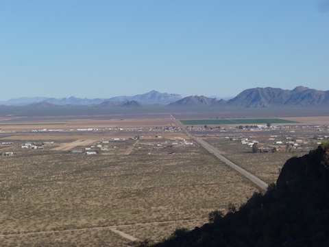
I like maps. Always have. I can remember being maybe six years old looking at my dad’s camping topos, pretending I was moving troops. My favorite book was the West Point Atlas of Military History, which had those old-style slashes-for-hillsides topo maps for every battle in every war the US had been in from the French & Indian War through Korea. So, a few weeks ago, when I was looking at doing something near Alamo Lake, in satellite view, I noticed that there were these black splotches randomly around the western desert. Looked like lava cones, they were so dark compared to the surrounding terrain. I zoomed in on topo view for a splotch south of Aguila, and saw that there were two arches within a half mile of each other. At least according to the map, and as anybody who has been outdoors should know, maps lie. Happily, this time, they did not.
I planned out a route — because planning is what I do, like most people breath — but as any soldier knows, no plan survives contact with the enemy. So, at least as far as hiking goes, my plans are more guidelines to things I want to see, or routes that look like they might be good.
I don’t visit many cemetery’s, but it turned out there was some interesting graves, a few of which I straightened out as flags were drooping, or flowers had tipped over.
Pam and I then set out for Eagle Eye Mountain. She was a great pathfinder, finding routes up that I would have foregone for searching for an alternate, both on Eagle Eye Peak, and the mini-arch hill. As it was, for both, we took a different route down than up, giving future explorers two alternate approaches to each.
A couple of times we heard relatively sharp booms, which sounded like a large bore rifle, but then rather than hear a crack or zip nearby, we instead heard a boom overhead, going away, in a specific direction. Did not see any military jets, so not sonic booms. Also not explosive, as the sound was directional, rather than general. (Did hear some very deep, barely audible, rumblings that were probably explosive.) Saw 9mm luger, 9mm parabellum, .30-06, .30 (!?), .40 S&W, .22, 7.62×39, and some other shells I don’t remember. Also found an unfired copper-jacketed, boat-tailed, rifle bullet — just the bullet, no casing — a little larger than a .22. Pretty certain it was not .223 / 5.56, as I’ve seen those lots of times in the Army. Maybe a .270? Beware there is a shooting gallery / junkyard west of Eagle Eye Mountain, though Pam and I did not go there.
Final mention of things military, we saw a couple old radial-engine planes apparently doing touch & gos at the Aguila air strip. Looked like WWII trainers, or possibly a dive/torpedo bomber. Unfortunately, they did not give us a personal flyby. (Turns out they were T-6 Texans, in a RAF paint scheme.)
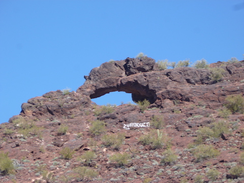
There’s actually quite a bit of graffiti throughout the area, not just under Eagle Eye Peak arch. Hiking it in the day required enough concentration; I’m not sure how drunks at night survived it. The rocks are mostly volcanic, though there was some that appeared to be some sort of sandstone. (Sorry, not a geologist.) Gloves definitely recommended.
The mini-arch south of Eagle Eye Mountain is “mini” only in that is smaller than the one on Eagle Eye Peak. The “mini” is actually large enough, and with a flat floor, that camping in it would be really neat, especially with stars and no light pollution.
It was fun exploring a place that was not one of the usual suspects, in a region which — at least in terms of HAZ hike descriptions (there were only three) — has been little served.
Final stop of the day was El Ranchero, for a Mexican dunch / linner, that all three of us loved. (El Ranchero is just west of the underpass on U.S. 60 in Wickenburg.)
GPS File: Eagle_Eye_Mountain
Distance: 3.40 mi.
AEG: 1,125 ft.
Time: 2h 01m