

As I discovered last year, the Black Canyon Trail (BCT) is a sorely underrated area for bagging #flowerporn. So, I put it on my list a spring hike in 2017.
I thought about doing two segments: Crown King Rd. to the ranching / mining hamlet of Bumble Bee, then Bumble Bee to Government Spring. The distance, about 11 miles, would not have been a problem, and neither would the elevation gain, maybe 1000 ft. But I would have needed my wife to drop me off at one end, then pick me up at the other, and thought with a heavily-travelled, twisty, dirt road, that might be an issue.
So, I decided to do one segment, Crown King Rd. to Bumble Bee. But five miles would have been nowhere near enough distance, so I did a map recon to see what else I could do that would make it worth fighting I-17 traffic to get to. Then I noticed an unnamed spur of Black Mesa, just south of Sunset Point, that had an outcropping of white rock, what looked on satellite view like a rain apron, and a benchmark named “Bum”. Okay, not much, but it gave me reason to explore, and I could turn it into a loop.
![This game tank was constructed by the "Sunset Point Groupe" [sic] of Arizona Game & Fish.](http://prestonm.com/wp-content/uploads/2017/03/P1180999.jpg)
The hike, and the BCT itself, starts by heading south, back down the road, across the bridge, for a quarter mile to a rough jeep trail on the east side of the road. It is marked by a BCT trail sign on a fiberglass post. In 200 yds. the trail splits; go right. Pass through an open gate, after which the jeep trail follows a fence on your left. At a mile, there is a saddle with an informal firing range. (A quite common feature of the Black Canyon Trail.) Thankfully, the range is back-stopped and pointed away from the BCT.
The range is at the intersection of the BCT and another jeep trail. If you are simply doing the BCT segment out & back, head straight across the jeep trail to where the BCT turns into single track. (This is the direction from which I later returned.) Instead, I made a left to continue on the jeep trail, then a quick right when the jeep trail split again.
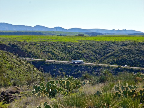
The jeep trail continues past the gas pipeline clearing & signs to the outcropping of white rocks, known as Hill 3185, at 2.0 miles. Bumble Bee, such as it is, is laid out before you, while the I-17 rest stop at Sunset Point is clearly visible. The white rocks looked like an area that might have crystals, but I did not spot any. It’s still a bit up to the top of Bum Mesa, but all your climbing for the day is done.
A quarter mile past the white rocks, on the east side of the trail is the game tank. It was not a rain apron — which gathers water over a large area, funneling it into spring boxes — but rather a couple of large corrugated metal sheets, flat to the ground. I started to look under the sheet metal, but then thought better of it, as that would be a prime rattlesnake nesting site. Somehow, it must gather or retain water, as it feeds to cement box at the far end, which was full of decent tank water. (Potable if filtered.) The game tank was constructed by the “Sunset Point Groupe” [sic] of Arizona Game & Fish.
There were flowers here & there along the jeep trail, mostly Wiry Lotus and Blue Dicks.
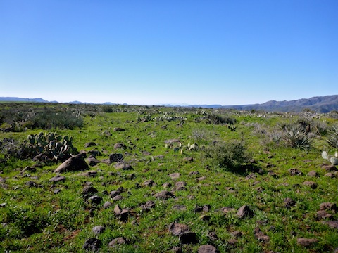
At 2.5 mi., where the jeep trail reaches Bum Mesa’s high point of 3298 ft., overlooking I-17’s descent towards Arrastre Creek, turn south, heading cross country towards the Bum Benchmark. Bum Mesa is dotted with volcanic bombs, prickly pear and some kind of plant that looks like agave, but isn’t nearly as stabby. It’s smooth travelling. When I was there, it was covered in grass so green it reminded me of Ireland. The same for the rest of Black Mesa, as well as the ranch below Sunset Point. I’ve never seen the desert so lush.
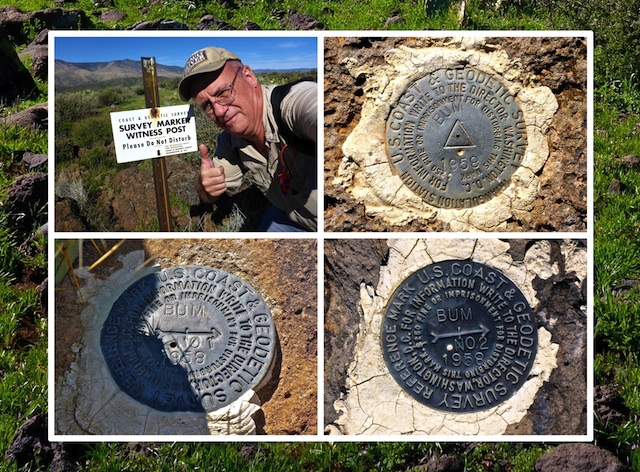
I found Bum Benchmark easy enough, as the disk was marked by a white sign. After taking a selfie for twitter, I started wandering off, only to walk over a second metal disk. It was unexpected. Now, I am no benchmark expert, but I knew the presence of an additional disk in close proximity meant there was likely at least one, possibly two, more nearby disks. I did find a third disk, but not a fourth. The proper term for the benchmark is a “triangulation station”, while the other two disks are “reference marks”. The arrow on a reference mark points at its associated trianguation station.
There are several spurs off the south side of Bum Mesa. I headed towards the one immediately south of Bum Benchmark and started down. I soon disabused myself of that notion, as it was slipperier than I was comfortable with. I side sloped west to the next spur which, though steep, was much easier to negotiate.
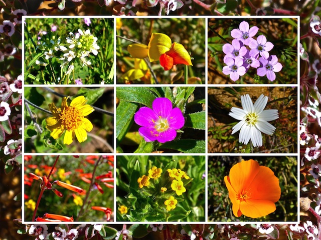
It may have been location, or time of day (nearly 11:00 a.m.), or both, but the side of Bum Mesa was covered with flowers: Chuparosa, lupine, fairy duster, and more. Some of the flowers were only 1-2 mm. This is what I came for! I photographed 15 different flower species. With such frequent photo stops, it took me the better part of an hour to reach the Black Canyon Trail at the foot of Bum Mesa.
There is no shade at all on the jeep trail up Bum Mesa, nor on the mesa itself, and only very minimal shade on the BCT. It was getting toasty, so I took a break in the only decent shade I found, wolfing down a QT sub sandwich and a Cerveza Modelo Especial.
Where the jeep trail was often rocky, the Black Canyon Trail is smooth as glass, and almost level, following the 2750 ft. contour line for two miles back to the firing range, before dropping a few hundred feet back to the Bumble Bee trailhead. If you do the whole BCT #8 segment from Crown King Rd. to Bumble Bee, 4.5 miles will net you less than 300 AEG. (Doing the segment southbound is still less than 500 AEG.) What little AEG there is from numerous small wash crossings. Even Phoenix canal walkers should have no trouble hiking this Black Canyon Trail segment.
Back at the Bumble Bee trailhead, I downed my usual frosty cold V-8. That may sound gross for an after hike refreshment, but the potassium, and especially the sodium, replace lost minerals and, more importantly, help prevent cramps. Besides, I actually like the taste. My wife, who again patiently waited for me, describe Crown King Rd. as a highway. Indeed, my car was covered with dust. On the way back to I-17 we passed a green Discount Cab. I never expected to see a taxi in the middle of nowhere! 😂
I had planned to stop at Rock Springs Cafe for some delicious pie, but we were in that awkward window midway between lunch & dinner and so skipped it. I got more plans for the Black Canyon Trail, so next time.
On the way back into Phoenix, the I-17 media through Anthem was absolutely choked with Mexican Gold Poppy, lupine & globemallow! 😳
Directions: From I-17 at the Loop 101 in Phoenix, head north on I-17 for 33 miles to Crown King Rd., Exit 248. Pass under both segments of I-17, taking care not to get back on I-17 southbound or, worse, against the flow of southbound traffic. (Easy to do if you are not paying attention.) The road is very twisty. In a mile, on the left, will be the Crown King Rd. trailhead. The road soon turns to dirt. Two miles from I-17, merge north on Crown King Rd. Five miles from I-17, you will cross a narrow bridge over Bumble Bee Creek. Park in the best spot you find after crossing the bridge.
GPS File: BCT_8_Bum_Mesa_Lasso
Distance: 8.32 mi.
AEG: 1,078 ft.
Time: 3h 37m
Black Canyon Trail Video
Black Canyon Trail: Crown King Rd. to Bumble Bee from Preston McMurry on Vimeo.