

Every Easter, my wife & I visit our younger son, and his family, in Hagerstown, MD. The highlight is watching our grandaughter’s Easter egg hunt. Each trip follows the same pattern: Fly into Baltimore on Thursday, fight rush hour traffic west on I-70 to Washington County, check in at the SpringHill Suites at the Valley Mall, dinner at Olive Garden. Friday, since normal — i.e., not retired — folk have to work, I hike. Saturday is buying Easter provisions and visiting. Sunday is egg hunting, eating and more visiting. Somewhere in there, we always fit in a trip to Waffle House. (Like I told someone on twitter the other day, when I die, bury me in biscuits & gravy. ![]() ) Not much different than anyone else’s holiday, other than maybe the hiking.
) Not much different than anyone else’s holiday, other than maybe the hiking.
I make it a point to hike wherever I travel: Belgium, the Netherlands, Scotland, Wisconsin, Pennsylvania … even Houston! ![]()
As Hagerstown is less than 30 minutes from the Appalachian Trail, that has been my Easter hike of choice since 2012. (Other than 2015, when I instead hiked the Antietam National Battlefield at nearby Sharpsburg.) I’m not sure how thru-hikers divvy up the sections, but I’ve parceled Maryland’s 40-something miles into five sections: Harpers Ferry to Crampton’s Gap (2016), Crampton’s Gap to Turner’s Gap (2013), Turner’s Gap to I-70 (2012), I-70 to Wolfsville Rd. (2014) and Wolfsville Rd. to Pen Mar, PA (next year?). Each segment is short enough that I can hike it in a half day, leaving time to visit family. Each section also begins and ends on a road, so my very supportive wife can drop me off at one end, and pick me up at the other end. (And get in some antiquing while she’s at it. ![]() )
)
Given the title of this hike, I don’t always hike the segment south-to-north, like most thru-hikers do. I hike them in whatever direction my mood moves me. Today, I wanted to tourist in Harpers Ferry, so I hiked south.
The Weather Channel claimed it was 62° (!) in Hagerstown, so figure 59° on South Mountain, or about twice as warm as the 30° I normally experience on my Easter hike. I don’t know if it was quite that warm, but it was definitely an improvement. Despite the temps, I still carried only a liter of water with me. No hiking poles, pack or gear. (It would be a pain hauling all that stuff across the country.) Just a camera and a crappy Garmin 62S.
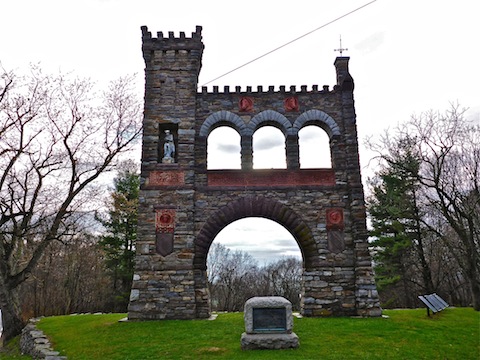
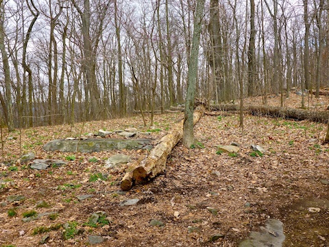
I started at the Townsend Monument, dedicated to war correspondents who perished in the line of duty. The most recent additions were in 2003. I briefly checked out the remains of Townsend’s mausoleum, passed some A.T. maintenance folks, then headed off through the near leafless woods. As elsewhere in Maryland — other than an extremely rocky 1.5 mile section north of Black Rock Gap — the trail was smooth as could be. Unlike Arizona, I did not need to worry so much about footing, and could look around while I walked.
One mile is not much different than any other mile along the Maryland portion of the A.T.: It’s less about the trail, than it is about the interesting things you find along the way. ![]()
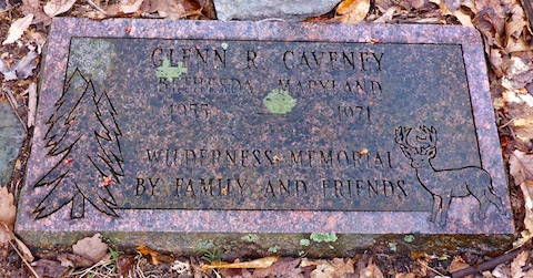
The first highlight, 1.5 miles south of Crampton’s Gap, was a memorial stone, a few yards east of the trail, laid flat in the ground. As photographing memorials & cemeteries is a hobby of mine, I stopped to check it out. It read “Glenn R. Caveney, Bethesda, Maryland, 1955-1971, Wilderness Memorial by Family and Friends”.
I heard the loudest woodpecker ever. It didn’t sound very tap-tap-tappy; more like CLOCK-CLOCK-CLOCK, as if someone was slapping 2x4s together.
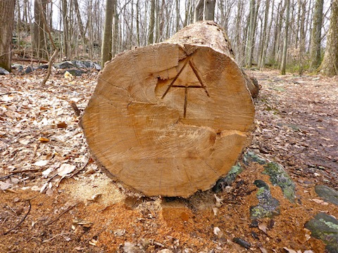
The larger cross trail deadfall has been cut out, so hikers can save themselves 18″ of elevation gain climbing over the logs. ![]() One dead tree had the A.T. symbol carved in its end. I counted the rings: It was close to a hundred years old. Shame.
One dead tree had the A.T. symbol carved in its end. I counted the rings: It was close to a hundred years old. Shame. ![]()
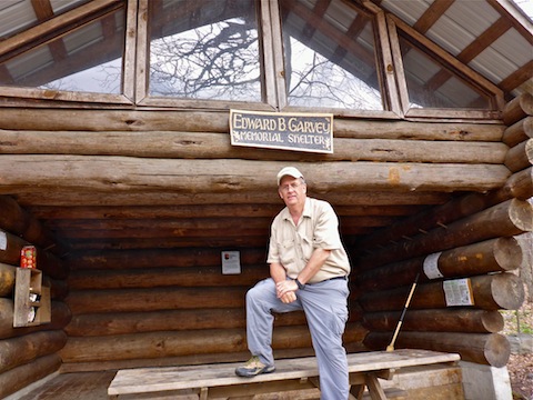
Three miles into my hike, I came upon the Edward B. Garvey Memorial Shelter. Both Ed and Glenn were A.T. maintenance volunteers. (Ed for many more years than the unfortunate Glenn.) The shelter is pure luxury: two stories, the upper enclosed with glass / plexiglass, the lower open. There is a fire pit with nice benches, a bear box and two — count ’em, two! — pit toilets: One open to enjoy nature / disburse fumes, the other a more traditional outhouse. As it is too early in the season for most thru-hikers, no one was home. But while I was checking it, two other day hikers entered the camp. By pure coincidence, one of them was on site when Jason Parish was killed by the falling tree last March.
I passed another A.T. maintenance crew south of the Garvey Shelter. The crew leader said they were working their way north to meet the other crew in the middle. Three miles is a lot of work in one day! ![]()
The two hikers had clued me into Weverton Cliffs, so a few miles later I diverted a couple yards off the main trail to check them out. There had been some breeze here and there, but it was blowing much harder through the mountain gap, at the bottom of which was the Potomac River. No way George Washington threw a cherry across that thing! While traffic noise from Maryland Highway 67 had been audible on the way south, the noise from U.S. Highway 340, along the Potomac was loud enough even 500 ft. up that I could hear truck tires brrrping over bridge seams. Still, great view, with Harpers Ferry visible in the distance, at the base of Blue Ridge.

I took the official switchbacks down, but other than LNT preserving the natural terrain, there’s no reason not to go straight over the side of the cliffs. Steep, yes, but not sheer. When I got to the trailhead at the 67 & 340 intersection, I discovered there was no toilet. And I had to go. Oops. Should have gone back up the hill. Instead I had to hold it for another 90 minutes.
I crossed under 340, passed over the railroad tracks — there is no tunnel or bridge, and the tracks are very active, so watch out! — then followed the C&O Canal Towpath west. The Potomac’s rapids were loud, and the canal had a lot of algae. And turtles. Lots and lots of turtles. ![]()

The two old bridges across the Shenandoah River from Virginia to Harpers Ferry are now nothing but pylons, but there are three bridges over the Potomac: The first is U.S. 340, so don’t get your hopes up that your hike is over. You still have a mile to go. ![]() The second two, side-by-side, are the “new” railroad bridge, and the “old” railroad bridge. The pedestrian bridge, which is quite popular with families and tourists, is attached to the old railroad bridge.
The second two, side-by-side, are the “new” railroad bridge, and the “old” railroad bridge. The pedestrian bridge, which is quite popular with families and tourists, is attached to the old railroad bridge.
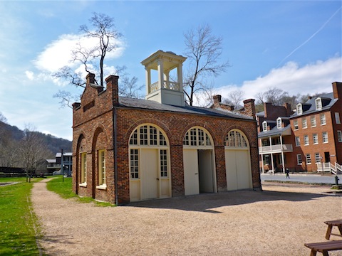
The old firehouse, aka “John Brown’s Fort” is at the southern end of the bridge, in downtown Harpers Ferry. The original location, where what were essentially the first shots of the Civil War were fired, is just across the street, slightly up hill, and is marked by a small spire.
I started late, and had taken longer than I planned, so my touristing was limited to adding two t-shirts to my collection of ~140, then some food & beer along the small strip opposite the still active train station.
One more Maryland Appalachian Trail segment to go!
GPS File: AT_Crampton_to_Harpers_Ferry
Distance: 11.30 mi.
AEG: 997 ft.
Time: 2h 50m
Hike Video
Appalachian Trail: Crampton Gap to Harpers Ferry from Preston McMurry on Vimeo.