

Last week, exploring Bullard Mine, was an ‘away’ hike. This week was supposed to be another ‘locals hike’. My plan was to hike a loop from Spur Cross Trailhead, just north of the city of Cave Creek, on Cottonwood Trail #247 to Cottonwood Spring, then back on Trail #247A. It didn’t quite work out that way.
I left home a bit later than normal, so I headed north, rather than south to the 7th St. QT where I normally pick up my pre-hike food. I got Mickey D’s at the Valero on Thunderbird instead. Rather than eat while I drove, I figured I’d eat at the trailhead, and catch up on Twitter while the sun rose. But the trailhead, despite being only four miles north of the city of Cave Creek, had only one bar Verizon reception. Nothing would load. That sucked. 🚫🗼
The $3 entrance fee envelope station used to be unattended, but now there is a volunteer-staffed booth. I would have paid anyway, as that is a ‘tax’ that goes to something useful.
I stopped to use the massive handicap-accessible portapotty just past the booth. Both portapotty doors were red, indicating occupation, so I waited. And waited. And waited some more. Someone die in there? Finally, I knocked. No answer. I opened the door. No one in the portapotty. Some wit had slid the lock just far enough shut to indicate occupation but not actually lock it. I’m sure the park ranger standing nearby was wondering what kind of wierdo I was.
The last time I hiked Cottonwood Trail #247 to Cottonwood Spring, it turned into a bit of a death march, as it was late May, so already basically summer. I started thinking wierd thoughts like “Drop your pack” and “Cut across country”. Neither of which would be wise choices when one is bordering on heat exhaustion. Thankfully, I still had the presence of mind to stay on trail, despite the grind.
This time around, it was 43℉, and breezy, so I wore my hoodie.
The hike to Cottonwood Spring starts north on FR 48. In 1.2 miles, you cross most likely dry Cave Creek for the first time. There used to be an ironic board across Cave Creek. Just the other side of Cave Creek’s raging waters, you leave the Spur Cross Conservation Area, entering the Tonto National Forest.
FR 48 soon disappears to become single track trail. The hike crosses to the east side of Cave Creek, then back to the west side at the corral which marks the junction of Limestone Trail #252. At 2.2 miles the hike crosses Cave Creek for the fourth & final time, to the east bank. Even two miles north, Cave Creek is still usually bone dry.
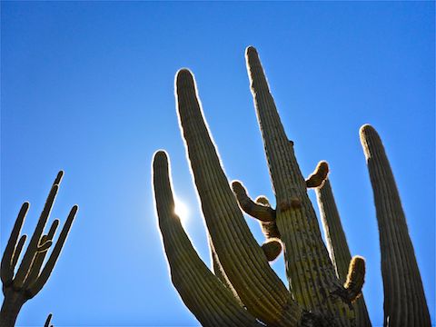
I saw two deer near the FR 48 corral, three javelina above Cottonwood Spring, and zero snakes — which is a rarity as the Spur Cross area is riddled with rattlers. 🐍
After the final Cave Creek crossing, Cave Creek Trail #4 splits left, heading north to Seven Springs, while Cottonwood Trail #247 begins, heading east to Cottonwood Spring and, eventually, Bronco Trailhead.
Cottonwood Trail #247 immediately begins climbing, about 800 ft. overall in 2.8 miles, but about 1100 AEG, because rarely in Arizona is an up straight up, without a few downs here & there. It feels steeper than it is.
There’s been a fair amount of recent trail maintenance on Cottonwood Trail #247: Grass trimmed, palo verde cut back, tread scrapped, diversions around eroded sections, and even several switchbacked reroutes (one a quarter mile of new trail).
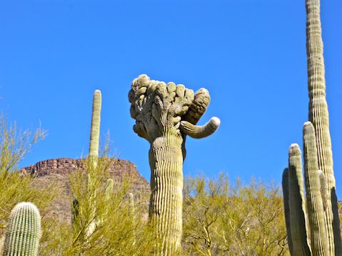
I’ve spotted at least four crested saguaro in the Spur Cross area, including two today. The first crested saguaro I saw today was 4.7 miles into the hike, crossing a wash. I’ve been by that spot twice and never noticed it before. (The price I pay for keeping my eyes down, looking for snakes.)
The high point, in more ways than one, of the Cottonwood Springs Loop is less than a quarter mile from the crested saguaro: A counterweighted, self-closing, gate. I love that thing. I played with it for a few minutes.
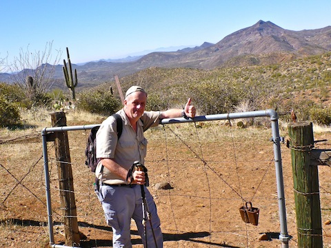
Skull Mesa Trail #248 intersects the Cottonwood Trail #247 at the counterweighted gate. It is 1.1 miles and 1100 AEG to the summit. (Not counting any exploration of the 5.5 miles circumference top of Skull Mesa.)
From the counterweighted gate, Cottonwood Trail #247 descends 250 ft. in a half mile to Cottonwood Spring. Just above the spring, there is a fence and old wood gate. Nothing remains but the decaying posts. As I approached the gate, I rousted the javelina I mentioned earlier.
Cottonwood Spring had puddles, and maybe a slight trickle. It was as shady as ever, and the hanging coffee can was still there. That thing might predate Arizona’s statehood. 😁
I was going to take a break in the Cottonwood Spring oasis, but forgot because I was so into shooting my hiking video (see below).
After relaxing at Cottonwood Spring, my recommendation is that you head back the way you came.
Trail #247A — it has no name — splits off at the hanging coffee can. The access is not obvious, so I built the world’s worst cairn.
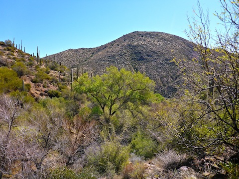
Trail #247A climbs 250 ft. in a third of a mile. It is rocky, and overgrown with brush. It’s obvious no maintenance has been done on it in years. I don’t recall #247A being that way in 2012. Once the climb is done, Trail #247A clears, and begins descending towards the house at Little Wonder Spring.
I didn’t quite get there. A mile southwest of Cottonwood Spring, Trail #247A dead ends at the Tonto National Forest boundary, which is signed private property and “Horse & Hiking Trail North of Fence Line”. The arrow points up in the air, but I wasn’t easily fooled: I was on the north side of the fence.
I searched in vain for where Trail #247A might continue like it did six years ago. I couldn’t find it, and not feeling like heading 6.5 miles back the way I came, I began bushwhacking along the fence line, heading down into washes, then up over ridges.
Just over the first ridge, I found a shady tree, so sat down for some a snack of gorp & G2. As I got up from my break, I discovered the second crested saguaro of the day. 🤗
Properly refreshed, I continued to bushwhack, getting cut up by catclaw in the process. After a mile of bushwhacking, I connected back up with what I believed to be Trail #247A. Subsequent sat view analysis shows the trail I got on heads northeast, to connect with Cottonwood Trail #247 near Rock Tank Spring, not east towards Trail #247A at the “do not enter” signs. Yeah, me neither.
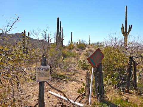
Back on trail, I boogied back towards the Spur Cross trailhead. Near some benches, the trail crossed out of the Tonto National Forest. I saw a sign, facing south. When I looked back, the sign was some sort of government “do not enter” sign. Okay … Maybe put some signs up elsewhere so one does not cross into the endangered blue snail darter habitat, or whatever it was, in the first place?
Directions: From Loop 101 / Pima Freeway, head north on Cave Creek Rd. for 12.2 miles. Just as the road curves east into ‘downtown’ Cave Creek, turn left onto Spur Cross Rd. Take the next right, then a quick left. The trailhead is four miles ahead. The final mile is semi-paved but car drivable. There is no fee to park, but there is a $3 envelope fee to hike / bike / horse ride into the conservation area.
GPS File: Cottonwood_Spring_Loop
Distance: 10.33 mi.
AEG: 1,835 ft.
Time: 4h 29m
Hiking Video
Hiking Cottonwood Spring Loop, Spur Cross from Preston McMurry on Vimeo.