

I started hiking at 0750. It was sunny, 34 degrees, no breeze (praise jeebus). I was hoping to get started by 0730, but I sat in car for 20 minutes drinking coffee and waiting for sun to start warming the air a bit. (It was still a bit dusky in the canyon, and the creek crossing was very icy.) Despite a definite clockwise tendency, I did this counterclockwise, and am glad I did, as it gave me a chance to enjoy the best part of the trail while I was fresh, rather than later when I could have used an airlift. Cave Creek Trail #4 goes south paralleling the creek bed for 1.0 km, where it crosses a spur road, then turns west past Cartwright Ranch, continuing to follow the creek. This is probably not a good time of year to hike in the creek, as there was ice in many parts. Continue 2.0 km west to the first creek crossing, at the slatted sluice thingy. (For want of a more technical term.) This whole segment reminded me a lot of Wisconsin in the late fall, after the trees have lost their leaves. It might not be everybody’s cup of tea, but I thought it was beautiful. Actually, the whole 6 km to the Skunk Creek Trail #246 turn off was my favorite so far in the Phoenix area.
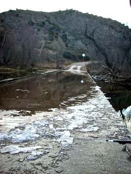
After the first creek crossing, you will continue on a grassy bluff, well off the creek, for 1.5 km to the second creek crossing. Lots of animal tracks in this segment of the trail. Far side of second crossing is marked by a cairn, of which there are many along the whole 17.3 km loop. The segment to the third crossing, skirting the southern edge of Cramm Mountain is a bit narrower and rockier, but even more scenic as the creek narrows and boulders up. Even with more concentrated water flow, there was still ice shelves on the edge of the creek. Just before the third crossing is a rock that someone carved “AB, April 7(?), 1917”. Stupid camera somehow lost that photo, plus six others. Definitely getting a new point-and-shoot soon. Anyway, it is possible to stay dry on all three crossings, with a bit of back- or pumpkin, but the third would be the most difficult to stay dry, and may require a bit of bushwhacking afterwards to get back on trail.
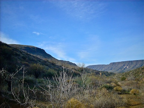
After the third crossing, it is just a few hundred meters to the Skunk Trail #246 turn off. That is where the joy ends, and the pain begins. The first 1.5 km of switchbacks is a serious grind. After the switchbacks, still climbing, the trail gets extremely narrow, four inches in places, rocky, and very close to a steep bluff. Be very careful with your footing. I recommend doing the trail counterclockwise for that reason, as I find it easier to maintain my balance going up, rather than down. Great views west to New River Mesa on the far side of Cave Creek. Just be careful turning around for pictures.
As you approach Skunk Tank, the footing gets much less iffy. The tank itself just seemed to be a bunch of reeds. If there was water, it was very low. Turn left through the gate, and begin another 1.5 km climb to the Quien Sabe Trail #250 junction. Although there are some very small climbs, from Trail #250 the trail is generally downhill. Also, by that point, with 6 km remaining, I was totally gassed. It took a lot of mental toughness for me to continue. (Perhaps mental toughness is another way of saying “not much choice”?) Saw the only other hikers, two gals going clockwise, just after crossing Quien Sabe Creek at 13.2 km total distance. We stopped for a brief chat — “what’s ahead?” — then continued.
Just after you spot Cartwright Ranch, the trail crosses a wash. Be careful not to go off trail down the wash, as it will take you west. A couple hundred meters after that, you will cross Cottonwood Trail #247, and a couple hundred meters after that, a fence, and then re-introduce yourself to Cave Creek. I was too tired to search for a good crossing, so rolled up my pants and hey-diddle-diddled right up the middle. By that point I was so tired, that I did not bother to climb the few meters up the trail, but instead took the spur road back to FR 24 and the trailhead.
Distance: 10.74 mi.
AEG: 2,347 ft.
Time: 4h 00m